Haruka Yoshimura, Ph.D.
 |
Fig.
1 Recreational
Shellfish Harvesting during Spring Low Tide (Tokyo:
35°41′ N, 139°47′ E) from the series Cultures and Customs of Edo throughout Four Seasons,
Tchikanobu Yosyu (揚州周延, 1838–1912), originally published 1890 (Image courtesy of the National Diet Library, Japan).
Historically, Japan developed unique mitigation measures
to protect
coastal areas from risk of coastal hazards such as tropical cyclone (typhoon) and tsunami integrated with marine resources management.
Along the coastal landscapes elaborately shaped by humans, marine resources
were abundant and varied, which in turn provided venues for numerous pleasurable
activities for people. This multi-colored print in the Meiji era (1868–1912)
depicts people enjoying shellfish harvesting nearby the central part of the
city of Edo, sea-breeze blowing softly onto a young mother and two boys with
a basket full of clams (蛤,
Orient clam, Meretrix lusoria, the most valued clam among variety of
calms). As depicted in the middle distance, expensive large fishes such as red seabream (tai, 鯛, Pagrus major, up to 1 m/3.3 ft) and flounder (hirame, 鮃, Paralichthys olivaceus, up to 85 cm/3 ft), which highly
praised for Japanese cuisine sashimi (sliced fresh fish served raw with
garnished herbs) and/or Edo-style sushi (sliced raw/cooked fish/shellfish
on an oval-shaped ball of vinegared rice), were able to be caught by hands. While
specifically designed for Edo, the comprehensive approach of ‘landscape architecture
between the sea water and the sea-strands’ is appliable to many coastal cities
around the world as mitigation measures suitable for the era in the face of
climate change. |
Edo (lit., bay-entrance or estuary), the former
name of the Japanese capital Tokyo (35°41′N, 139°45′E; Fig. 6-A), lies
on the shores of Edo (Tokyo) Bay. In 1590, Ieyasu Tokugawa
(徳川家康1542–1616) settled in Edo and
established his Shogunate (military governing dynasty) in 1603. Edo
began to increase in extent and population, and had estimated population of
over 1,000,000 as early as the middle of the eighteenth century, making it the largest metropolis in the worlds (Sansom 1963;
Uspensky 2003).
Edo depended upon resources such as grain (rice,
barley, and so on), building materials and other material goods from distant
parts of Japan (Sansom 1963). On the other hand, fisheries resources were
abundant and varied, and were adapted to almost all the requirements of the people
so it should not be necessary to depend on any other parts of Japan for the
supplies. Edo had a strong cultural relationship with the natural environment
of coastal zones. The ties with the coastal sea were felt even nearby the central
part of the city. Recreation of edible shellfish gathering at spring low-tide (Fig.
1) represents essence of the effective policy and management strategies.
Although humans depend upon marine ecosystems for diverse resources and
services, productivity and functions of the ecosystems are deteriorating (Worm
et al. 2006; Halpern et al. 2008; Diaz and Rosenberg 2008). Consequently, global
fisheries landings have been declining since the late 1980s (Pauly et al. 2003; Pauly and Zeller 2016). Seafood supply
to meeting the protein requirements of human populations is important for human
health (Golden et al. 2016), food security (Garsia and Rosenberg 2010), and for
social resilience (Adger et al. 2005; Goes et al. 2020). In Edo, the food
security supported by fisheries productivity was reflected in the policy of
land governance. Japanese land governance in coastal
zones was unique.
Hiroshige Utagawa (歌川広重1797–1858) illustrated
many coastal landscapes in urban and peri-urban areas of Edo, showcasing
landscapes of diverse site-specific design
strategies by unique engineering techniques to protect coastal areas from risk of
coastal hazards, to control erosion, and to maintain productive fisheries. Notably,
Japanese coastal protections were designed to preserve/restore submerged vegetation
and beaches which occur in front of the structures and adjoining unprotected beaches.
Owing to his samurai background, Hiroshige had knowledge of the
conceptual framework for design and land-use planning in Eastern philosophy. Hiroshige
depicts the integrated coastal management strategies
of the megacity in the context of a great conurbation.
Cities are supported by appropriate ecosystem services in urban areas and
from around the world (Folke et al. 1997; Kaye et al. 2006; Grimm et al. 2008).
However, capacity of the planet to sustain cities with ecological services is
increasingly eroded (Hooke et al. 2012). Therefore, there is pressing need to
take into account appropriate ecosystem services in urban governance to sustain
cities (Seitzinger et al. 2012).
Management of coastal ecosystems is connected with important policy
issues: coastal hazard mitigation, management of fisheries resources for food
security, erosion control, natural sinks on land and
the ocean removing atmospheric CO2
via photosynthesis (Canadell et al. 2007), and CO2 sequestration in a
vast area of ocean (known as ‘blue carbon’). A strategic approach for restoration
of resilience of coastal ecosystems should be reflected
in policy decisions.
1.2
Increasing risks of coastal hazards in population in coastal area
Rapid
population growth and urban land expansion in coastal area
Historically, populations have preferred live in estuarine and coasts. Although low-elevation coastal zones below 10 m
(33 ft) elevation covers only 2% of the world’s land area (McGranahan et al. 2007),
an estimated population between 750 million and nearly 1.1 billion lives in
these zones in 2015 (MacManus et al. 2021). The global population reached 8.0
billion in 2022 (UN 2023). The population growth in the low-elevation coastal
zone is assumed to continue to increase (Neumann et al. 2015).
The low-elevation coastal areas are among the most rapidly urbanizing
around the world. About 34% of the area of urban land use, impervious surfaces
and the built environment, occupies within 10 m of low elevation coastal zones.
Urban land expansion rates in the coastal zone were significantly higher than
in the non-coastal hinterland from 1970 to 2000 (Seto et al. 2011). The coastal
urbanization can be expected to continue into the future or to even increase (MacManus
et al. 2021).
Increasing
risks of coastal hazards in population in low-elevation
coastal zone
Coastal
populations in coastal lowlands of less than 10 m elevation are especially
vulnerable to risks of sea-level rise resulting from climate change (Nicholls
and Cazenave 2010), storm-surge flooding by stronger tropical storms (Emanuel
2005; Rahmstorf 2017; Garner et al. 2017), and tsunamis (Kron 2013; Esteban et al.
2013; Maramai et al. 2014).
Currently, ecosystem structure and function in estuarine and coastal seas have been lost as a result of human activity (Lotze et al. 2006). Coastal habitats provide buffers in protecting coastlines (Shepard et al. 2011; Narayan et al. 2016), and comprise the basis for fishery productivity (e.g., Chesney et al. 2000). Therefore, the degradation of coastal wetlands, salt marshes and mangroves, can result in an increased vulnerability of populated coastal zones and depleted fishery resources.
2.
Need for land governance in land-sea interface
2.1 Unforeseen negative impacts of hard engineering coastal defense
system: Negative impacts on climate; Accelerated erosion; Loss
of nursery and foraging grounds
2.1.1
Negative impacts of hard coastal structures on
climate
To
date, risk management policy on coastal protection has relied heavily on hard measures
such as seawalls and bulkheads (Airoldi and Beck 2007;
Rosenzweig et al. 2011; Suppasri et al. 2016). In Europe alone, 22,000 km2
of the coastline are artificially covered with concrete or asphalt, and artificial
surfaces increased by almost 1,900 km2 between 1990 and 2000 alone (Airoldi
and Beck 2007). Gittman et al. (2015) estimated that 22,842 km of continental
US shoreline – approximately 14% of
the total US coastline – has been hardened and armored.
Photosynthesis
in coastal zone influences global climate, via natural sinks on land and the ocean removing atmospheric CO2 through photosynthesis (Canadell et al. 2007), via
CO2 sequestration in
the deep sea (phytoplankton: Field et al. 1998, Falkowski et al. 1998; coastal vegetation:
Duarte et al. 2005, Duarte 2017),
and via solar radiation valance. The
hard engineering coastal defense systems destroy the most productive estuarine
and coastal ecosystems, which in turn leads to unforeseen negative impacts on global
climate: weakening CO2 sequestration capability; rising sea surface
temperatures and increase in evaporation from oceans. Declining marine
photosynthesis (coastal vegetation and phytoplankton) weakens the capacity of natural
sinks removing atmospheric CO2
and CO2 sequestration in the deep sea, which sequentially accelerates
global warming. Decline of marine photosynthesis results in decrease of absorbed
solar radiation energy by photosynthetic plant pigments. The fraction that
previously absorbed for photosynthesis is absorbed by sea water, which in turn
increases in sea surface temperatures. Evaporation from the oceans can increase,
as the fraction of solar radiation energy that was previously absorbed by
photosynthetic pigments is allocated to latent heat flux (solar radiation
energy used to evaporate water from the ocean surface). Intensified supply of moisture
source of precipitation by the warmer wetter marine air leads to changes in
precipitation pattern, and increase the frequency and severity of tropical
cyclones (http://harukanoor4.blogspot.com/2022/).
2.1.2 Accelerated coastal erosion
Sandy
beaches, which occupy more than third of global coastline, are already eroding.
Furthermore, sandy shorelines worldwide are under threat of erosion due to the
rising sea levels and more intense storms by climate change (Vousdoukas et al.
2020).
The
hard engineering coastal defense structures such as seawalls, which grow rapidly
in the second half of the twentieth century, accelerate erosion, causing beach
loss. The reflected wave energy by the seawall leads to scour at the base of
seawalls, accelerating beach loss in front of them. And eventually, larger and
stronger seawalls are needed over time (e.g., Loucks et al. 2005). Furthermore,
hardening shoreline promotes erosion an adjacent beach. Increasing development
and seawall construction result in expanding erosion and beach loss due to flanking:
erosion triggered and accelerated by nearby hardening
shoreline (Summers et al. 2018).
Recent
studies using satellite images to track the shoreline change reveal that coastal
shorelines worldwide are rapidly eroding (Luijendijk et al. 2018; Mentaschi et al. 2018). The ongoing coastal erosion degrades
coastal resilience and increases vulnerability against coastal hazard caused by
sea level rise and increased extreme weather expected with climate change.
The
natural coastal replenishment dynamics have already altered, because sediment
supply to coastal regions decreased, due to installation of dams (e.g., Mentaschi et al. 2018). Therefore,
design for shoreline stabilization and implementation of effective adaptive measures
are required more than ever before.
2.1.2
Failure to protect coastal communities
Failure of hard measures on the 2011 Tohoku tsunami
Although coastal protection has relied heavily on hard engineering measures
in risk management policy, it is
becoming increasingly clear that hard structures can fail.
‘Tsunami,’
most commonly generated by earthquakes in marine and coastal regions, is a Japanese word, represented by two characters tsu
(津, meaning ‘harbour’) and nami (波, meaning ‘wave’). Major tsunamis, produced by large and shallow focus
earthquakes associated with the movement of oceanic and continental tectonic
plates, frequently occur in the Pacific, where oceanic plates slide under the
continental plates (Bernard et al. 2006).
On 11
March 2011, a 9.0 magnitude earthquake occurred 130 km (81 miles) off Japan’s Pacific
coast. This earthquake (epicenter: 38°06.2′ N, 142°51.6′
E; depth: 24 km/ 15 miles) triggered a massive tsunami, causing extensive
damage mostly along 600 km (373 miles) of the Sanriku Coast, killed 15,883 people, with an additional 2,656 missing (Mori
et al. 2011; Tsuji et al. 2014).
While there is no other nation that engineering
measures such as concrete seawalls and flood dykes have been developed to
protect populated coastal areas from tsunami, the coastal hard countermeasures
were significantly damaged by the tsunami.
At Taro
in Miyako city (39°44′ N, 141°59′ E), the huge wave poured over the
seawalls (with a height of 10 m/33 ft and a total length of over 2.4 km/1.5
miles), consequently swept away almost all houses and fishing facilities (Tsuji
et al. 2014). The tsunami waves, topped around 20 m/66 ft, battered other
coastal sites. The tsunami waves penetrated inland and traveled up rivers,
overflowing river banks. In the 2011 Tohoku tsunami,
the maximum run-up height was 39.7 m (130 ft) at Miyako (Mori et al.
2011).
Tsunami
wave amplifies in funnel-shaped bays such as submergent coastline: drowned river valleys or rias (Mori
et al. 2011; Suppasri et al. 2013), and drowned glaciated valleys or fjords (Maramai
et al. 2014). The height of inundation and run-up at the mouth of a bay increases
much higher inside the bay, as the wave reflections and refractions within the
bay. Due to the local geography of submergent coastline of rias, the Sanriku
Coast has a long history of devastating tsunamis with the amplified waves. As a
countermeasure, large-scale tsunami breakwaters were constructed at the entrance
of the bay notably in Kamaishi and Ofunato. In Kamaishi (39°16′ N, 141°53′ E), the
world largest concrete caisson seawall erected to protect harbor in the entrance
of the Kamaishi bay at a depth of 63 m/207 ft, a length of 2 km/1.24
miles and a cost of JPY 120 billion ($1.5 billion), in addition, populated coastal
areas were completely surrounded by concrete tsunami walls up to 6.1 m/3.3 ft. Although
the concrete caisson seawall helped to reduce the impact of the tsunami and to
delay the arrival time, both of the engineering structures, the caisson seawall
at bay entrance and concrete tsunami walls, were collapsed by the waves and
they did not prevent major destruction and loss of life (Suppasri et al. 2013).
2.1.4 Ecosystem-based coastal protection
Coastal
vegetation has provided coastal protection from waves and storm surges, for
millennia. Salt marches reduce the height and velocity of incoming waves by buffering
of vegetation structures and stabilizing sediment, rising the marsh land height
(Morgen et al. 2009; Barbier et al. 2011). In addition, marshes are effective
in wave dissipation of storm surge and remain resilient even at extreme events
(Möller et al. 2014).
Similarly,
seagrass meadows stabilize sediment by the roots and rhizomes, preventing
erosion, which in turn provide shoreline protection (Duarte 2002). Kelp forests
reduce the longshore current and wave energy, promoting sedimentation. Notably,
ecosystem-based coastal protection has the benefit that coastal plant habitats
can adapt to changes in climate, and self-repair after major storm events (Morris
et al. 2020).
Therefore,
coastal defense using natural or restored vegetated coastal habitat systems
plays a critical role in reducing the vulnerability of coastal communities that
faced with a changing climate (Temmerman et al. 2013; Spalding et al. 2014).
2.2 Loss of nursery and foraging grounds leads to decline of global fisheries
1.2.1
The nursery role of underwater seagrass
meadows.
Most
marine species of commercial value require more than a single habitat to live
and spawn. The fish species of major industrial offshore fisheries, such as Alaska
(walleye) pollock (介宗鱈, Theragra chalcogramma, the most landed
species on the planet), Atlantic cod (Gadus morhua), Pacific cod (真鱈, Gadus macrocephalus), Atlantic herring (Clupea harengus),
and Pacific herring (nishin, 鰊, Clupea
pallasii), spend their adult life shoaling in deep offshore waters where they
live, feed, and spawn. However, juveniles require seagrass meadows as nursery grounds where young growth stages can take
advantage of the protection and abundant food. Although
the important link between seagrass meadows and offshore fisheries may not
always been appreciated, loss of seagrass meadows (nursery and foraging
grounds) leads
to decline of productivity of global fisheries (Unsworth et al. 2018).
1.2.2
The nursery role of salt marshes.
The coastal vegetation provides essential nurseries for commercially important fish/shellfish species: salt marshes,
mangrove forests (Moyle and Cech 2004), and kelp forests (Dayton 1985). Intertidal
salt marshes in temperate and high-latitudes serve as nurseries for commercially important fisheries species, such as
shrimp, oysters, clams, and fishes (Boesch and Turner 1984;
Moyle and Cech 2004; MacKenzie and Dionne 2008). In spite that several kinds of shrimp live
and spawn as adults offshore, they require salt marshes during critical life history
stages as nursery grounds. Salt marsh ecosystems provide refuge habitat that is
mostly inaccessible to large fishes by their complex and tightly packed plant
structure, along with abundant food. Shrimp is important in the diet of almost all
commercially important fish species of coastal fisheries at one history or another.
Salt marshes associated fisheries productivity arises directly the provision of
nursery and forage grounds for various fish and invertebrates. Thus, salt marsh
ecosystems enhance quantity and quality of fisheries resources (Boesch and Turner
1984; Barbier et al. 2011).
Salt marshes play a significant role in supporting fisheries
productivity. However, the connection between salt marshes and offshore fisheries
have not been fully appreciated as a result of perceived spatial disconnect
(most fishing activity take place offshore) (Odum 1971). Loss of salt marshes (nursery
and foraging grounds) leads to decline of productivity of local and global fisheries.
2.2.3 The nursery role of kelp forests.
Nursery role of kelp forests
Kelp forests serve to maintain fisheries as nursery and foraging
grounds (Moyle and Cech 2004). Shaffer et al. (2020)
provide intriguing insights into nurseries of kelp forests, which are densely
inhabited by juvenile salmonoids and forage fishes, in a case in the northeast
Pacific nearshore. Due to the structural complexity, the kelp forests
provide refuge from predators. Global fisheries production is maintained by marine
food webs—the flow of energy from phytoplankton (primary
producers) through intermediate consumers to predators. In the kelp forests, phytoplankton
are consumed by zooplankton (small crustaceans such as copepods and decapods). (Decapods are an order
of crustaceans, including many commercially important fishery species, such as crabs,
lobsters, shrimp, and prawns.) Sequentially, these smaller zooplankton are
consumed by forage fishes: small, schooling, filter-feeding fish such as Pacific herring (Clupea pallasii), surf smelt (Hypomesus
pretiosus), and Pacific sand lance (Ammodytes hexapterus). The forage
fishes are then consumed by commercially important
salmonoids, including Chinook salmon (Oncorhynchus
tshawytscha), coho salmon (O. kisutch), steelhead trout (O. mykiss),
and cutthroat trout (O. clarkia). Furthermore, kelp zones are important
for Pacific herring, as extensively used for spawning (Shaffer et al. 2020).
Loss of kelp forests leads to decline of herring
and salmonoids
Kelp forests are typically found in temperate waters between 6 and 30
m (17 and 98 ft) (Moyle and Cech 2004). Kelp forests dominate along
approximately one-quarter of the world’s coastlines (Filbee-Dexter and Wernberg
2018), because brown algae have evolved to extend their distribution deeper
seawaters than seagrasses.
Kelp forests are declining across the globe (Lotze et al. 2006; Krumhansl
et al. 2016; Filbee-Dexter and Wernberg 2018; Coleman et al. 2022). Because of the important
link between nursery habitat and fisheries productivity (Unsworth et al. 2018),
loss of kelp forests (nursery and foraging grounds) leads to decline of productivity
of herring, salmonoids, and valuable commercial crustaceans.
Herrings distribute throughout the northern coastal marine areas of
the Atlantic and Pacific oceans and parts of the Arctic Ocean. In the 20th century
many herring stocks around the world have collapsed (Hay et al. 2001). High abundance
of forage fishes such as Atlantic herring (Clupea harengus) and Pacific
herring (鰊, Clupea
pallasii) plays a vital role in global fisheries production and global food
security (Smith et al. 2011). Therefore, the population collapse of herring (Clupea
spp.) is a challenge to sustainable fisheries management (Trochta et al. 2020).
Since the 1850s, the Pacific salmon, including Chinook salmon (Oncorhynchus
tshawytscha), coho salmon (O. kisutch), steelhead trout (O.
mykiss), and cutthroat trout (O. clarkia), have been declining, while
many stocks have been completely extirpated (Nehlsen et al. 1991). Pacific salmon
have a broad range throughout north portions of the Pacific Ocean and have a
complex life history: most forms are anadromous with a juvenile phase in fresh
water, followed by a long migration to the ocean for feeding/growth, and generally
return to their natal streams for spawning.
In the temperate and subarctic regions of North Atlantic Ocean, the
abundance of adult Atlantic salmon (Salmo salar)
returns among many wild and hatchery stocks has declined since 1985. Despite of
the implementation of recovery program such as closure of commercial fisheries,
restriction/prohibition of angling, and removal of dams, the collapse of some
stocks has occurred (Dadswell et al.
2022).
Loss of kelp forests may lead to decline of commercially
important crustaceans such as lobster, red king crab, and snow crab
Shaffer et al. (2020) indicate abundant decapods (an order of
crustaceans, including lobsters and crabs) in the kelp forests in a case in the
northeast Pacific nearshore, which suggests that many valuable commercial
crustaceans such as crabs and lobsters use kelp forests as a nursery and feeding
grounds. Despite of the increasing economic importance of crustaceans to humans
(Susanto 2021), commercially important crustaceans are declining in the seas
around the world.
Norway’s coastal lobster fishery has a long history. Export of live
lobster to central Europe started around 1650. The official landing of 1.3
million (515 tons) of the European lobster (Homarus gammarus) in 1928 is
declined to 41 tons in 2019 (Kleiven et al. 2022).
In Kamchatka in far eastern Russia, large-scale fisheries of the red king crab (タラバガニ, Paralithodes
camtschaticus, a highly valued delicacy on the international market), started
in 1925, and by 1927 annual landings were as high as 30 million crabs. Despite repeated
fishery closures, the abundance of P. camtschaticus
decreased. Landings of the reopened fisheries in 2013 was 6,785 tons, which
was less than one tenth of the landing in 1927. Red king crabs were historically
fished in spring in coastal waters at the approximate depth of 10–30 m (33–98 ft) where red king crabs gather for mating (Dvoretsky and Dvoretsky 2018). Which suggests that red king crabs use kelp forests for spawning, as kelp forests
are typically formed in the depth of coastal waters. During summer and autumn,
fishing follows red king crab migration to depths greater than 35 m (115 ft) and
then down to 100 m (328 ft) (Dvoretsky and Dvoretsky 2018).
The commercial fishery of red king crabs (P.
camtschaticus) in Peter the Great Bay, Sea of Japan, commenced in 1874,
was contributed to industry of canned king crabs with the high export value. Associated
with improved fishing methods, landing of P. camtschaticus increased
and reached to 11,500 tons in 1943. However, these overfishing led to depletion
of red king crab abundance. Despite repetitive fishery closure, the commercial
stock of this region was only 830 tons in 2000 (Dvoretsky
and Dvoretsky 2018).
The second largest population of red king crab resides in the Bristol
Bay, Alaska, in the southeastern Bering Sea. During 1959 to 1979, trawling and
tangle-net fishing were prohibited in a 67,000 km2 area of Bristol Bay (shaped a broad and unbroken
coastal zone) known as the Pot Sanctuary, which was
once a successful reproductive strategy for red king crab, the most valuable
single-species fishery in Alaska. In 1980, bottom trawling was begun within the
Pot Sanctuary. Landing of male red king crab in 1980 recorded 59,000 tons, but
by 1983 the catch had dropped to zero (Dew and McConnaughey 2005).
Socio-economic resilience of the Northwest Atlantic coastal zones of Newfoundland
and Labrador, Canada, depends upon fisheries resources. The early 1990s’ fishery
closures of Atlantic cod (Gadus morhua) and other important fish stocks
such as American plaice (Hippoglossoides platessoides) increased in importance
of fishery of snow crab (ズワイガニ, Chionoecetes
opilio). The snow crab resource is in decline, after peaks in the late
1990s and between 2008 and 2010. Landings
have been maintained at 50,000–60,000
tons since 1999. In spite of world’s largest snow crab fishery since the mid-1990s,
recruitment prospects are diminishing: reduced abundance of all sizes; a marked
decrease in the abundance of mature females (Mullowney et al. 2014).
Fisheries productivity is supported by nursery grounds: salt marshes, seagrass meadows, and kelp forests. To restore productive fisheries productivity, there is an urgent need to preserve/restore salt marshes, seagrass meadows, and kelp forests as nursery grounds. Acknowledged that fisheries productivity plays a vital role in food security, a strategic approach for restoration of large-scale coastal ecosystems should be reflected in the policy decisions.
3. Unique approaches to coastal hazard mitigation in Eastern philosophy
3.1 Effectiveness of
natural landforms (geographical features) on tsunami mitigation
Since the Indian Ocean tsunami in 2004 and Hurricanes Katrina and Rita
in 2005, the need for an integrated approach to resilience of coastal ecosystems
that support local societies and economies, and coastal hazard mitigation has
been recognized (e.g., Adger et al. 2005). There is mounting evidence that
natural landform provides buffering from tsunamis. In the
Indian Ocean
tsunami on 26 December 2004
generated by an earthquake of magnitude 9.0 off the west coast of northern
Sumatra (Indonesia), villages situated behind the elevated places with steep
topography and/or dunes were protected against the huge tsunami waves in India
(Kathiresan and Rajendran 2005; Chadha et al. 2005) and Sri Lanka (Liu et al. 2005). In
Chile, dune provided buffering from tsunami waves in
the Chile tsunami on February 27 2010 generated by a large earthquake of M 8.8
(Esteban et al. 2013). Presence of coastal vegetation has been recognized as effective
in reducing the deaths and damages caused by the 2004 Indian Ocean tsunami in India
(Danielsen et al. 2005; Chadha et al. 2005), in Sri Lanka and Thailand (Tanaka
et al. 2007) and in Indonesia (Laso Bayas et al. 2011). The natural coastal elevated
landforms (topography) along with presence of vegetation such as dense mangrove
forests increase tsunami mitigation effectiveness, in the 2004 Indian Ocean tsunami
in India (Kathiresan and Rajendran 2005).
3.1.2 Legend in tsunami
mitigation in Japan
3.1.2.1 Ancient legends
of tsunami mitigation in Japan.
As the Japanese archipelago is prone to tropical
cyclone and tsunami, once Japanese architects were aware that local
geographical features such as island, coastal hill and/or
cape contribute to coastal protection by reducing
wave energy.
The scientific definition of a tsunami is a series of sea waves generated
by earthquake, landslide or other disturbance under the ocean. However, a Japanese
word ‘tsunami’ included exceptional storm surge (an episodic increase in sea
level driven by shoreward wind-driven water circulation and low atmospheric pressure)
caused by tropical cyclones (typhoon) until around the Meiji era (1868–1912). Numerous local chronicles indicate that coastal
topography such as island, coastal hill and/or cape together with vegetation
cover provides natural barrier against coastal hazard such as tsunami and storm
surge.
3.1.2.2 Tsunami
mitigation Hachiman.
A legend of tsunami mitigation during the Kamakura period (1185–1333)
influenced urban design of Edo. In Edo, Japanese architects
evolved diverse tsunami mitigation structures. The Kamakura Shogunate was
established in 1185 by Yoritomo Minamoto (源頼朝) in Kamakura (鎌倉: 35° 19′ N, 139° 33′
E; Fig. 6-C). Based on the Japanese traditional land
planning, the government built numerous Shrines/Temples
to maintain appropriate ecosystem areas of strategic importance integrated with
military strategic points. As Hachiman (八幡, the Japanese Shinto god of war, originally an agricultural deity
in local area in Kyusyu) became the guardian of the Minamoto
clan, huge number
of Hachiman Shrines/Temples were constructed.
In 1311, devastating tsunami (probably a storm surge at local scale) hit
in Yokohama, near the entrance of Edo (Tokyo) Bay. The tsunami
destroyed a village, but the neighboring village was less impacted, safe and
sound. Tomioka Hachiman (富岡八幡: 35°22′ N, 139°38′ E; Fig. 6-D) on coastal mountains (around 40 m/131
ft) covered with dense forests acted as a buffer and protected the village behind
it. For which, people adored it, called as Namiyoke Hachiman
(波除八幡, tsunami mitigation Hachiman). It was particularly popular among merchants associated with shipping
and fishermen seeking to give sail without trouble.
3.1.2.3
Ancient legend: Effectiveness of multiple-buffering in tsunami mitigation
Tsunami mitigation legend of Matsushima
Although the origin of the legend is unknown, the tsunami mitigation of
Matsushima (松島, 38°38′ N, 141°07′ E) in effectiveness of multiple-buffering was recognized among the ancient
Japanese architects and decision makers in ancient times. Hence, decisions were
made to provide adequate tsunami mitigation effectiveness, by adopting the multiple-buffering
in coastal design and land-use planning.
In Fig. 2, Hiroshige depicts a bird’s-eye perspective of the Matsushima
Bay from Tomi-yama (116.8 m/383.2 ft asl), a coastal mountain, viewing dotted
200 islands, seen in the far background Miyato-jima
Island and Shichigahama Peninsula lying at the bay entrance. This
print is depicted natural structure of multiple-buffering ranged 6.7 km (4.2 miles)
long from the bay entrance to inside coast, which provided effective buffering against
the destructive tsunami waves.
Effectiveness of the multiple-buffering in the 2011 Tohoku tsunami
Matsushima, famed for its beautiful scenery, is close to
the epicenter of the earthquake that generated the 2011
Tohoku tsunami. In the Matsushima Bay, protruding Shichigahama Peninsula and Miyato-jima Island lying
in the mouth of the bay provide a sheltered harbor. The semicircular-shaped
bay, 1.7 km (1miles) wide at the entrance, is dotted by over 200 small islands
covered by trees of Japanese black pine (Pinus thunbergii).
On 11 March 2011, the tsunami destroyed nearby
coastal communities. For instance, Minami-Sanriku (a town near the bay
entrance, 38°41′ N, 141°28′ E), where tsunami inundation height measured around
15 m (50 ft), was destroyed and about 1000 people died or missing in this town
of 17,700. The tsunami waves hit the island lying in the mouth of the bay, inundation
height ranged 8 and 9 m (26 and 30 ft), caused considerable casualties. Whereas,
inside lowlands of the Matsushima Bay suffered relatively
little damage. The tsunami inundation height around 3 m/1 ft and there were
2 losses of lives. In some sites, the elevation of watermarks on buildings indicated
much lower inundation heights of 1.2 m (3.9 ft) or 0.5 m (1.6 ft) (Hasegawa et al. 2011).
Huge tsunami waves at the mouth of the bay had reduced to around 3 m (9.8 ft) or less by the time they reached the inside town, as Shichigahama Peninsula and Miyato-jima Island lying at the bay entrance behaved as a large-scale tsunami breakwater caisson, and dotted islands acted as a buffer.
Fig.
2 View
of Matsushima with a Distant Prospect from Tomi-yama Mountain (Matsushima, Miyagi prefecture:
38°38′ N, 141°07′ E) from the series Pictures of Legendary
Landscapes in the Sixty Provinces, Hiroshige, originally published 1856–1858
(Image courtesy of the Waseda University Library, the ukiyo-e.org https://johnresig.com/projects/ukiyoe/ by Resig J). Hiroshige depicts a bird’s-eye
perspective of the dotted some 200 islands in the Matsushima Bay from a coastal
mountain (116.8 m/383.2 ft asl), seen in the far
background Miyato-jima Island and Shichigahama Peninsula lying at
the bay entrance. The Tohoku tsunami on 11 March 2011 destroyed nearby
towns, but damage of inside lowlands of the Matsushima Bay was relatively
minor. Because the island and peninsula lying at the bay entrance behaved as a large-scale tsunami breakwater
caisson, and dotted some 200 islands acted as a buffer. This Hiroshige’s
print represents how vegetated multiple-buffering structure
should be shaped to
provide adequate tsunami mitigation effectiveness. |
3.2.1
Placement of multiple-buffering to protect low-lying
coastal areas and to stabilize beaches
To sustain the megacity of Edo that rapidly increased in extent
and population, the coastal zones of Edo Bay had been dramatically transformed
by humans. The coastal architecture to protect low-lying coastal areas was unique
in translating learning-based knowledge into effective policy and management
strategies. Ancient Japanese architects and decision-makers developed site-specific
civil engineering design in coastal protection: construction of multiple-buffering
structure and strategic placement of coastal ecosystems which provide nursery
and foraging grounds for fisheries productivity.
In traditional Eastern philosophy, management of fisheries resources was
considered as a core issue of governance for food security. Therefore, the primary
functions of the sea dyke system were to protect low
lying coastal areas from inundation by the sea and also to enhance resilience
of coastal ecosystems as the nursery and foraging grounds for fisheries
productivity. Japanese dyke system was intended to shape complex
habitats: coastal forests, salt marshes, underwater seagrass meadows, and
deep-water kelp forests.
For instance, an ancient marsh reclamation work at the ancient sea shore of Edo Bay (Fig. 3; Fig. 6-E) represents the Japanese multiple-buffering coastal protection structure.
Fig. 3-1 Azuma-no Mori Shrine and the Entwined Camphor (Tokyo: 35°42′
N, 139°49′ E; Fig. 6-E) from
the series One Hundred Views of Edo, Hiroshige, originally published 1856–59
(Image courtesy of the ukiyo-e.org https://johnresig.com/projects/ukiyoe/
by Resig J, the Artelino). According legend, during his campaign against
the tribes in eastern Japan, Prince Yamato-takeru was caught by a storm
in boats in Edo Bay. He survived through the self-sacrifice of his wife Princess
Ototachibana. When he reached a small islet among marshes, he built an
earthen mound and buried her robe that was deposited on shore by the waves. This
legendary coastal area had been reclaimed in ancient times, until around the Kamakura
period (1185–1333). Hiroshige depicts the ancient sea
dyke system in the foreground, and the Azuma-no Mori Shrine at the upper
left of the picture.
Fig. 3-2 Schematic
structure of coastal multiple-buffering system in a case of the Azuma-no
Mori Shrine. In reclamation work of Eastern philosophy, earthen dykes,
elevated mounds/mountains and artificial islands combined with intertidal
wetlands were placed to protect low-lying coastal areas. The earthen dykes were
intended to stabilize beaches. To close biogeochemical cycles in land-sea connectivity, continuous (non-fragmented) vegetation, deep sacred
forests, trees planted on the dykes, and salt marshes, was elaborately shaped. Marine
photosynthesis requires huge amounts of essential nutrients such as Fe and Si
compounds in the forms of humus, leaf litter and detritus. The shaped continuous
vegetation works as a pathway of essential nutrient from land to sea. Thereby, submerged
aquatic vegetation, underwater seagrass meadows and deep-water kelp forests, flourishes.
The flourishing underwater vegetation, in turn, contributes to stabilize beaches. Multiple-buffering system, which consists
of diverse habitats, supports land-sea linkage in biogeochemical cycle as basis
of fishery productivity. 
The history of reclamation in Japan dates back to the Nara
period (A.D.710–794), around 1,300 years ago. Hiroshige depicts a well-preserved
landscape of the ancient march reclamation work at the ancient sea shore of Edo
Bay in Fig. 3-1.
Azuma-no Mori Shrine was devoted to the worship of the deity
of Princess Ototachibana. This shrine is surrounded by myth and legend. During
the campaign against the tribes in eastern Japan, the legendary Prince Yamato-takeru,
his wife and entourages, were caught by a great storm in boats crossing in Edo
Bay. In order to appease the anger of Ryujinn (龍神, the Japanese mythological god of the sea, typically portrayed as dragon),
his wife, Princess Ototachibana leapt into the seething waves. Prince Yamato-takeru survived through the
self-sacrifice of his wife and reached a small islet shore among marshes safely.
A few days after the Princess’s death, the waves deposited her robe on shore. Prince
Yamato-takeru built an earthen mound and buried it beneath the mound.
This legendary coastal zone had been reclaimed in ancient times. In 1199,
Yasutoki Hojo (北条泰時, 1124–1242), the head of the Kamakura
shogunate, ordered construction of the shrine building (Fig. 6, E).
Ieyasu settled in Edo Castle (Fig. 6-A) in 1590 and began to organize the new
capital. The tidal marshes in the eastern part of the Sumida-gawa River
(Fig. 6-B) had been reclaimed for urban development from around 1596 (Endoh 2004).
Kita-jyukken-gawa River, seen in foreground in Fig. 3-1, was a
canal, dug out in 1663 to link Sumida-gawa River (which was separated
from the Tone-gawa River to reduce flood risks in city of Edo in
1629) and Naka-gawa River (Fig. 6-F, an arm of the Tone-gawa
River that flowed into Edo Bay), probably along ancient earthen sea dyke.
Hiroshige depicts the ancient reclaimed marsh land with
the Azuma-no Mori Shrine in the center of the picture, viewing from the
direction of the Edo period’s reclaimed land. In Fig. 3-1, the ancient
reclaimed marsh land is protected by irregularly bending earthen
sea dyke on which pines and cherry trees are grown. The entrance approach
to the shrine is marked by a torii gate. Along the gateway, on one side there
are rice paddies. On the other side of the gateway, an extensive area of salt marsh pool (in ancient time) is connecting irregular-shaped
moat system enclosed the precinct of the shrine.
The multiple-buffering coastal protection system
consists of earthen sea dyke, salt marsh pool, elevated
mound covered with a sacred forest like an old-growth forest consists of diverse
native tree species, saltwater-filled moat, and dyke of moat (Fig. 3-2). Ancient
Japanese architects innovated diverse design of multiple-buffering coastal structure
appropriate for local
and regional geography, and social requirement.
1.2 Strategic placement of continuous (non-fragmented) vegetation over
land and sea to close biogeochemical cycles
3.3.1 Architecture of pathway
to close biogeochemical cycles
Pathway of essential nutrients supply from
land to sea
In Eastern philosophy, one of the important concepts in land-use
planning/management was to close biogeochemical cycles,
known as rinne 輪廻: ‘cycle of life.’ For architecture of underwater seagrasses meadows and deep-water kelp
forests, ancient Japanese civil engineers had taken a unique approach to close
biogeochemical cycles. In the reclaimed marshlands, earthen
sea dyke was constructed to create calm shallow sea waters for rapid restoration
of submerged aquatic vegetation. Strategic placement of continuous
(non-fragmented) vegetation over land and intertidal zone (for instance, in Fig.
3-2, a series of sacred forest and salt marsh) was intended to restore submerged
aquatic vegetation over coastal sea. Continuous (non-fragmented) vegetation over
land and intertidal zone facilitates flow of essential nutrients from land toward
coastal seas. The dynamic flow of essential nutrients in land-sea connectivity,
in turn, leads to resilience of underwater vegetation as nursery grounds—basis
of fisheries productivity.
Note that supply of essential
nutrients for marine photosynthesis (blooms of diatoms-dominated phytoplankton
and marine vegetation) is not equivalent to nutrient loading, because nutrient
loading (nutrient pollution) from synthetic
fertilizers in agriculture and from treated/untreated sewage effluent induced
by rapid urbanization causes harmful algal blooms, which are increasing
frequency and intensity on a global scale (e.g., Parsons and Dortch 2002; Anderson
et al. 2008; Heisler et al. 2008; Paerl and Huisman 2008). Terrestrial and
marine ecosystems shape consolidated closing biogeochemical cycle, constituting a complex and dynamic system. Marine
photosynthesis requires huge amounts of essential nutrients such as Fe
and Si compounds in the form of humus, leaf litter and detritus from terrestrial
vegetation. Decay of the blooms of diatoms-dominated phytoplankton and coastal vegetation
release nutrients. The released nutrients in turn enrich nearby coastal seas.
Submerged aquatic vegetation requires supply of essential
nutrients from land
Submerged aquatic vegetation, seagrass meadows
and kelp forests, requires supply of essential nutrients from land.
Primary production of marine
phytoplankton (single-celled algae with invisible size) is enormous. Marine phytoplankton produce nearly half of
global net production each year (Field et al. 1998). Diatoms (single-celled
algae armored with silica cell walls) dominated phytoplankton blooms play a
dominant role in shaping our productive fisheries (Armbrust 2009; Goes et al. 2020).
The diatoms-dominated marine phytoplankton,
the basis of abundant fisheries resources, require supply
of essential nutrients from terrestrial vegetation, such as iron ‘Fe’ (Martin and Fitzwater 1988; Kuma and
Matsunaga 1995) and silica ‘Si’ compounds (in light of ‘evolution of modern eukaryotic
phytoplankton’: Falkowski et al. 2004). Therefore, large quantities of essential
nutrients equivalent to approximately half of global net primary production must
be supplied from terrestrial vegetation.
Likewise, supply of essential nutrients from
terrestrial vegetation plays a significant role to sustain the nursery and foraging
grounds. The availability of soluble Fe, which derives from organic compounds
via the leaf litter decomposition of forests, is required for growth of kelp
forests (Matsunaga et al. 1999)
All living things
are made of one or more cells, and all the cells are mostly composed the same
substances that carry out similar biological functions. When the living cells complete
their life cycle, all the essential nutrients of cells tend to circulate in the
biosphere, known as biogeochemical cycle. Cytochromes,
for instance, a group of hemoprotein cell components with a central Fe atom at its
core, serve a vital function in both photosynthesis and cellular respiration.
As cytochromes are found all animals and plants, and many microorganisms, humus
and organic compounds from terrestrial vegetation (e.g., leaf litter, wood, and
other plant parts) that exported to seas/oceans are source of Fe compounds.
Hence, soluble Fe compounds and/or cytochromes derived
from an enormous amount of organic matter from terrestrial primary productivity
may contribute marine primary production such as phytoplankton and macroalgae that form underwater kelp forests.
Architecture of biogeochemical pathway in land-sea
connectivity
Resilience of seagrass meadows, the important nursery
and foraging grounds, requires habitat connectivity. Seagrass meadows are connected
adjacent salt marshes, oyster reefs, and sandy shores in temperate regions; and
the seagrass meadows are associated with mangroves and coral reefs in the tropics
(Unsworth et al. 2015). Furthermore, a considerable portion of net production
of seagrasses exports to adjust ecosystems both to the land and seaward (Duarte
2002), suggesting interdependent trophic links between terrestrial and submerged
aquatic vegetation. The linkages between intertidal wetland vegetation and seagrass
ecosystems facilitate transfer of large amounts of essential nutrients associated
with leaf litter and detritus in sustaining productivity of the nursery grounds.
In Eastern philosophy, the basic concept underlying
the design of multiple-buffering was to close biogeochemical cycles. Placement of
contiguous ecosystems: deep sacred forest, salt marsh pool, and earthen sea
dyke, was designed to serve a pathway of biogeochemical cycles. Ecological connectivity between land and sea plays a significant
role, as abundant essential nutrients produced by terrestrial vegetation transport
to underwater seagrass meadows and deep-water kelp forests.
Unique design of coastal engineering to shape calm
shallow seawater
Aware that submerged aquatic vegetation plays an essential role in fishery
productivity, unique design of coastal engineering had been developed in
Eastern philosophy.
Seagrasses grow in soft mud/sand in calm shallow seawater. The irregularly
bending earthen sea dykes were intended to stabilize beaches in front of the
structure and to restore intertidal vegetation such as common reed (Phragmites
australis) and submerged aquatic vegetation over coastal sea (Fig. 3-1, 3-2). Numerous irregular-shaped earthen
groynes (groins), man-made sandbars that extended into sea from earthen sea dyke,
were constructed. These man-made sandbars were shaped by closely spaced wooden piles
driven into the seabed. In addition, ‘loosely spaced wooden piles’ driven into
the seabed served as a sort of breakwater, preventing the dyke being washed
away. These coastal dyke engineering structures create a condition of calm
shallow seawater, facilitating resilience of underwater
meadows of seagrasses. The resilience of seagrass meadows in front of the dyke
structure in turn shapes a variety of habitats: sallow slow-moving seawater and
still deep seawater wetlands, making nursery habitats where young growth stages
of fish and crustaceans can take advantage of feeding and protection from
predation (Fig. 3-1, Fig. 7-1, 7-2, Fig. 8-1, 8-6, Fig. 9-3, Fig. 10-1, 10-2,
10-3, Fig. 12-1, Fig. 13-2).
The roots and rhizomes of seagrasses stabilize the seabed, preventing
erosion, which in turn contributes to reduction of sedimentation type pollution
keeping clear waters (Duarte 2002). Underwater meadows of seagrasses perform a
function as pathway of essential nutrients supply from land to the deep-water
kelp forests. Human-created conditions: soil stabilization, wave attenuation, and
adequate supply of essential nutrients, facilitate colonization of the deep-water
kelp forests.
Ecological function: Pores of earthen sea dyke
Salt marshes maintain fisheries by serving nurseries for many fishes
and crustaceans (Boesch and Turner 1984). Accordingly, loss of coastal wetlands leads to depleted and collapsed
fishery stocks, in a case of US (Chesney et al. 2000).
Abundant fisheries resources are maintained trophic transfer in marine
food webs. In particular, shrimp is important in the excellent diet of almost
all commercially important species of coastal fisheries at one life history or
another.
Several kinds of shrimp live and spawn as adults offshore, and the
eggs and planktonic forms of young larva move shoreward into intertidal salt
marshes and associated networks of tidal creeks, embayment, and salt marsh pools.
The small eggs and planktonic forms of young larval stages
pass through barrier such as natural shaped earthen embankment, and take
advantage of refuge from predators and abundant food for rapid growth. The maturing
shrimp then move back to ocean for spawn (e.g., Odum 1971).
Shrimp productivity depends on area of vegetated
wetlands. In a case of in the northern Gulf of Mexico, the mean annual
yield of shrimp caught inshore is highly correlated with the area of vegetated
wetlands (Boesch
and Turner 1984). Due to the important link between nursery grounds
and fisheries productivity (Unsworth et al. 2018), loss of salt marshes leads to
decline of fisheries.
Placement of vegetated wetlands in Edo
Ancient Japanese architects were aware of a significant role of shrimp
in marine food webs in fisheries resource management. Therefore, vegetated wetlands
were strategically placed.
In Edo,
fairly small shrimp, shiba-ebi (芝海老, Metapenaeus joyneri, 10-15 cm/4-6 inches) serve to maintain
fisheries by enhancing quantity and quality of commercially important fisheries
species.
In light of nurseries of shrimp, ancient Japanese architects were
aware of ecological function of earthen dykes’ pores
that shrimp eggs and planktonic forms young larval stages pass through. Invisible
phytoplankton and zooplankton (small crustaceans such
as copepods and krill; larva of fish, squid, lobsters and crabs) also pass
through the pores of the dykes. Thereby, the invisible phytoplankton and zooplankton
via pores of dykes were constantly supplied as food for shrimp growth. Although
these earthen sea dykes were often retained by dry-stone wall, the pores of the
dykes do not undermine the ecological function due to spaces between the rocks
(Fig. 4). The earthen sea dykes were equipped with water gates, by which mature
shrimps move back sea. Abundant released shrimps via the water gates from
man-made ‘vegetated coastal wetlands’ boosted quality/quantity of fisheries
resources.
Owing to the land-sea interactions, coastal wetlands and the sea are
highly productive ecosystems maintaining commercially important fisheries
species. Earthen sea dykes’ pores play a
significant role in linkage between coastal wetlands and the sea, which is critical
for habitats of shrimp that enhance quality/quantity of fisheries resources.
3.3.3 Coastal architecture
for self-sustainability
In Eastern philosophy, land-use planning/management associated with high
primary productivity of vegetation such as forests over the whole country was
regarded as first principle in the critical infrastructure for food-security
via abundant fisheries resources management. Furthermore, unique design of river engineering in preserving natural
corridors of land-sea linkage was developed: Floods were allowed in desolate
areas to decrease peak discharge, volume, frequency of floods in inhabited
areas. Extensive flood-water retarding zones that served as a sort of ‘dam’
were strategically allocated over large geographic areas. Discontinuous levees
that directed waterflow were constructed, for guiding flood-waters into the flood-water
retarding zones. Besides, in estuarine and coastal zones, coastal protection
integrated with a variety of habitats for resilient fisheries was designed to close
the biogeochemical cycle between land and sea (http://harukanoor4.blogspot.com/2022/).
Strategy of coastal hazard mitigation in Eastern philosophy was unique
in taking into account maintaining the dynamic equilibrium
in land-sea connectivity. Unique design of coastal engineering was invented
to prevent erosion and accelerate soil sedimentation.
Whereas, coastal engineering structures were intended to preserve and
to restore submerged aquatic vegetation that serves
as important nursery grounds for fisheries. Management of high primary productivity
of vegetation such as forests over the whole country is an underlying requirement,
as the resilience of submerged aquatic vegetation, underwater meadows of
seagrasses and deep-water kelp forests, necessitates abundant supply of essential
nutrients from land via the pathways of biogeochemical cycles.
The coastal architecture that takes into account of a naturally dynamic
coastal system is a constructive method, because the landscapes constructed by the coastal engineering intended to preserve beaches
integrated with strategic placement of ecosystems, once established, becomes
more and more effective each year as it grows as a measure of coast-line stabilization
and for prolific marine ecosystems.
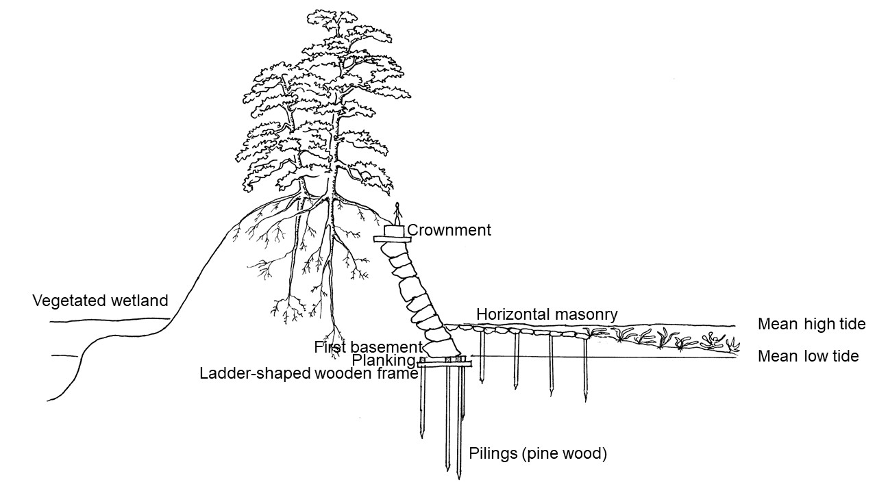 |
Fig. 4 Durable
coastal structure of dry-stone wall, preserving land-sea connectivity. Wooden pile
foundation after Ohno (1992). Shrimp play a significant role in marine food
webs, and shrimp productivity depends on area of vegetated wetlands (Boesch and Turner 1984). To enhance quality/quantity
of coastal fisheries, vegetated wetlands (nurseries of shrimp) with site-specific
design were strategically placed: seawater filled canal (Fig. 8-1, 8-2, 8-5; Fig.
9-1), and seawater filled ponds in lavished gardens (Fig.
8-3, 8-4; Fig. 9-2). Adult shrimp spawn offshore and young larval stages pass
through barrier such as earthen dyke via pores to use the nursery grounds of vegetated
wetlands. Japanese traditional dry-stone walls preserve the ecological function
of earthen dyke’s pores that pass through invisible phytoplankton and
zooplankton through the spaces between the rocks. In addition, Japanese traditional dry-stone walls are effective as
measures of erosion mitigation, as the spaces between
the rocks act to dissipate wave energy and minimize reflective waves. Traditionally,
seawalls were constructed using dry-stone walls in sites, where durability and
dignity were important (e.g., Fig. 7-1, 9-1). Owing
to the excellence in erosion mitigation, prolific fishery grounds are shaped in
front of the structure (Fig. 7-1). |
3.4 Unique civil engineering
technology in coastal hard structure: Magnificent durable coastal structure of dry-stone wall
3.4.1 durable coastal structure of dry-stone wall
Japan had unique civil engineering techniques in construction of man-made
island and/or sand bar.
A few years before Hiroshige created his series of “One Hundred Views of Edo,” Japan’s 250-year-old of
self-imposed isolationist foreign policy was on the transformative change.
On 8 July 1853, Commodore of the United States
Navy Matthew C. Perry entered Uraga harbor at the entrance to Edo
Bay with his squadron of four steam frigates. He brought a message from President
of the United States Millard Fillmore demanding to open Japanese ports to
American trade. After several days stay in Japan, Perry departed for Hong Kong,
promising to return the following year for the Japanese reply.
The arrival of the squadron forced the Japanese
government to think of coastal defenses. A series of
eleven island-forts (daiba, 台場: Fig. 5; Fig. 6-G) equipped
artillery between Shinagawa (品川, Fig. 6-H) and Fukagawa Susaki (深川洲崎, Fig. 6-I, the eastern estuary of Sumida-gawa River) in Edo
Bay was planned. Construction work began immediately after Perry’s departure and
six forts were complete within nine to ten months, another two half-finished. Japan
had construction logistics to carry out the intensive construction work of the
island-forts: square and/or pentagon-shaped island-forts influenced by Western citadel
architecture, with the sides 122 to 177 m (367 to 581 ft)
long, covered an area of around 33,000 m2 (about 8 acres)
respectively, all sides of the shoreline retained with dry-stone walls of around
7.76 m/25.5 ft height (Ohno 1992). The earth for the
forts (over 480,000 m3) was taken from the coastal hills of Shinagawa
(Goten-yama Hill, Fig. 5; Fig. 6-J) and Takanawa.
Perry returned on 13 February 1854 after only half a year. Offshore of Shibaura (芝浦, Fig. 6-K) a deep and wide channel provided only one route from the entrance of Edo Bay to the ports of Edo Castle for large freighters and fishing vessels. Due to the emergence of the man-made six island-forts, Perry and his squadron relinquished their plan of entering deep inside of Edo Bay. They landed Yokohama (横浜, Fig. 6-L) and Japan was forced to open up to Western trade. Eventually, the island-forts project was suspended.
 |
Fig. 5 Shinagawa: View of the station from Goten-yama Hill (Tokyo: 35°37′ N, 139°44′ E; Fig. 6-J) from the series Fifty-three stations of the Tokaido Highway, Hiroshige, originally published 1855. In 1853 the arrival of US Commodore Perry and his squadron of four steam frigates prompted the Japanese government to take emergency measures on coastal defenses. Due to strategic importance of offshore of Shibaura: only one route to the ports of Edo Castle for large vessels, construction of eleven island-forts (daiba, 台場) was planned. Within nine to ten months six forts were complete. The earth for the forts was excavated from Goten-yama Hill. Accordingly, the appearance of Goten-yama Hill changed radically, despite once one of the most popular places to admire the cherry blossom. Hiroshige depicts the traces of the earth excavated work of Goten-yama Hill in the foreground, and four recently constructed man-made island-forts, all sides of the shoreline retained with dry-stone walls, in the near distance.
3.4.2 Effectiveness of
dry-stone walls in erosion control
The dry-stone walls submerged by seawater were constructed upon wooden
pilings made of pine trees not to sink into the soft ground (Fig. 4). Conceptual
basis of this method is similar to the technology in Venice in Italy.
Venice, formed on a lagoon, was built on wooden piles (diameter: varying
from 10 cm/3.94 inches to 25 cm/ 9.84 inches; length: a maximum of 350 cm/137.8
inches to less than 100 cm/39.4 inches) made of variable
tree trunks, alder (Alnus spp.), larch (Larix
decidua), oak (Quercus spp.), and Scots pine (Pinus sylvestris),
to provide foundations for buildings on the soft ground. Above the pile head,
planking (two or more layers of timber) positioned horizontally. For planking, woods
made of variable tree species, larch (Larix decidua), oak (Quercus
spp.), and Norway spruce (Picea abies), were used (Macchioni et al. 2016).
These woods do not rot in wet and oxygen-poor conditions
and become as hard as stone when left in immersed in water.
In Edo, the dry-stone walls submerged by water were constructed
on wooden pile foundations made of pine trunks driven deep into the ground. Pine
round wood logs submerged in water do not decay in wet and oxygen-poor conditions.
To ensure the long-term stability, piling foundations were elaborately designed
(as for specific details, see Fig. 4).
Japanese traditional dry-stone walls are effective as measures of erosion
mitigation, eventually resulting in a stable coastline. The structure of the walls
is designed as a basis for self-organized ecosystems.
Steep slope stabilization of dry-stone wall achieved by root systems
of trees and vegetation binding stones together (Yano et al. 1983). For the stabilization
of banks, a perennial grass (Imperata cylindrica),
effective in erosion control of exposed soil owing to the quick growth, and
Japanese black pine (Pinus thunbergii, up to
over 40 m) were planted. The perennial grass (Imperata cylindrica)
spreads rapidly and binds stones together by the tough rhizome network. The Japanese
black pine (Pinus thunbergii), tolerant to salt spray, has ability to
endure unfavorable site conditions that other tree species do not thrive.
At the base and in front of the vertical masonry, rocks and wood piles
accumulate oysters that grow together, forming rock-like reefs. Which in turn
reduced wave energy preventing erosion. In Japanese traditional dry-stone
walls, the spaces between the rocks play important role in erosion mitigation.
When waves hit stone walls, the spaces between the rocks act to dissipate wave
energy and minimize reflective waves. The oyster reefs at the base and in front
of the vertical structure of masonry prevent erosion and provide productive coastal
habitats. The use of self-organizing ecosystems for the erosion control is a
constructive method, because the ecosystems, once established, becomes more and
more effective each year as it grows as a means of controlling erosion.
3.4.3 Wooden pile foundation
design of Japanese traditional dry-stone wall structure
An example of Japanese
traditional dry-stone wall structure along with wooden pile foundation
Ohno (1992) deals with wood foundations of Japanese traditional dry-stone
wall structure in a case of the Shinagawa-daiba (Fig. 4).
To ensure long term stability, piling foundations were elaborately designed.
Prior pilings, the soils underneath the masonry were consolidated. Crushed stones
were thrown in the ground to place the masonry with width 550 cm (18 ft) long
and depth 121 cm (4 ft) from the level of low tide. Piles (diameter: around 15 cm/6
inches), made of roundwood of pine (Pinus densiflora; Pinus thunbergii), were driven into the ground around
91 cm (36 inches) of pitch to form a long row along the masonry surface. Pile
length ranged from 637 cm (21 ft) in the outside row, 550 cm (18 ft) second row,
and to 455 cm (15 ft) in the inside row. Above the pile heads, wooden ladder-shaped frames were placed, as horizontal elements
to spread the vertical forces. The ladder-shaped frames mainly made of pine
round woods (diameter: around 21 and 24 cm/8.3 and 9.5 inches; length: 303 cm/99
ft) were set along the surface of masonry laying perpendicular to the driven piles,
and large iron stables were driven into both the
piles and wood frames to hold them together. On the ladder-shaped frames, pine timber
planking (thickness: 21cm/8.3 inches; width: 36 cm/12.5 inches; length: around 424
cm /14 ft) were positioned and stabilized using large iron
stables.
At the base of the vertical structure of walls, closely spaced pine wood
piles, diameter: around 12 and 15 cm (4.8 and 5.9 inches); length: 455 cm/15 ft,
were driven deep into the ground to reduce scoring of wave reflection (Ohno 1992).
In front of the vertical walls where prone to erosion by reflective
wave energy actions, horizontal masonries (width: 546 cm/18 ft or 728 cm/24 ft)
were constructed on wooden pile foundations. Pine round wood piles were driven into
ground as closely together forming 3 or 4 rows along the coast at intervals of
around 182 cm/6 ft. To make the wooden foundation rigid, horizontal elements of
pine wood were placed and stabilized using large iron stables.


 |
Fig. 6 Locations that Hiroshige depicts: (a) location of Edo and the peri urban areas; (b) Japanese map of Edo in 1849 (Image courtesy of the Geographicus Rare Antique Maps via Wikimedia commons); (c) Coastal area of Tokyo in 1959 (the Geographical Survey Institute, Japan). A: Edo Castle (Imperial Palace); B: Sumida-gawa River 隅田川; C: Kamakura (鎌倉, center of the Kamakura Shogunate, 1185–1333): D: Tomioka Hachiman (富岡八幡, legend of tsunami mitigation by a forested coastal hill); E: Azuma-no Mori Shrine (吾嬬の森, remnants of the multi-buffering coastal protection by ancient marsh reclamation); F: Naka-gawa River (中川, an arm of the Tone-gawa River); G: constructed island-forts (daiba, 台場, six island-forts were complete within nine months in 1854); H: Shinagawa (品川, a man-made long sandbar extruded out into the sea at the river mouth to protect the amusement quarters); I: Fukagawa Susaki (深川洲崎, sea dyke: a long earthen sandbar ran far out into the sea to protect the low-lying gavage filled-up land); J: Gotenn-yama Hill (御殿山, for the island-forts construction, the earth was excavated); K: Shibaura (芝浦, elaborately shaped coastal defense integrated with fisheries resources management in front of Edo Castle); L: Yokohama (横浜, a fishing village protected by two characteristic man-made island at entrance of embayment); M: Tsukuda-jima Island (佃島, artificial island at the mouth of Sumida-gawa River, serving as a sort of caisson breakwater); N: Fukagawa Hachiman (深川八幡, exquisite garden as part of multi-buffering coastal protection deserve to the Eastern Capital on the low-lying gavage filled-up land); O: Kiba (木場, lumber-yard, part of the multi-buffering coastal protection: seawater-filled ponds that the logs were stored and gardens of wealthy merchants); P: Fukagawa Susaki Jumantsubo (深川洲崎十万坪, vacant open space as a flood mitigation measure); Q: Hama-goten (浜御殿, sea shore palace, villa of the shogun family, a sort of outpost at the sea opening of the moat system of Edo Castle); R: Zojo-ji monastery (増上寺, The influential Buddhist center occupied an enormous area of 833,250 m2/206 acres covered with deep sacred forests, effective in urban summer cooling strategies); S: Suitengu shrine in Akabane (an example of protected urban forests: main residence of the Arima family from the north of Kyushu island); T: Furu-kawa River at Hiroo (広尾, placement of tall dense man-made forests surrounding farmhouses; small river engineering for prolific inland fisheries); U: Fudo temple in Meguro (目黒不動, man-made sacred forests to stabilize the fragile bluff of Musashino plateau and to enhance quantity/quality of groundwater); V: Haneda Benzaiten (man-made island covered with deep sacred forests at the estuarine of Tama-gawa River; currently occupied by the Haneda Airport/Tokyo International Airport); W: Futoko-tamagawa (二子玉川, popular place for anglers to enjoy ayu fishing along with the beautiful scenery of riffle-pool sequence river engineering); X: sea off the Miura Peninsula (placement of rocky reefs and man-made islands as consolidated structure of cliff erosion mitigation and productive coastal habitats); Y: coast of Tenjin-yama (placement of rocky reefs as consolidated structure of cliff /sandy coast erosion mitigation and productive coastal habitats)
4. Examples of site-specific design in the metropolis
4.1 An artificial island
at river mouth, served as a sort of caisson breakwater
At his age 39 during the ‘Warring States period’ (a period of
near-constant civil war and social turmoil), Ieyasu was at the verge of
the abyss. Mitsuhide Akechi (1528 ?–1582), an officer under the powerful
warlord Nobunaga Oda (1534–1582), raised rebellion
against his lord in 1582. Akechi’s forces surrounded Nobunaga,
who was resting in a temple in Kyoto. The temple was set on fire, and Nobunaga
perished inside.
When Ieyasu was learned about Nobunaga’s death, he was in
Sakai (Osaka Prefecture) where was Akechi’s
territory far from Ieyasu’s home Okazaki (Aichi prefecture),
with his several entourages without armament. As main highways and sea routes were seized
and taken control, Ieyasu decided to make across mountainous area of Iga
by foot over 100 km (62 miles), in spite of high risks of raids by armed
civilians. However, the retreat was obstructed by a huge flow of an arm of Yodo-gawa
River from the start.
At the difficult time of Ieyasu, fishermen in a Village Tsukuda
(佃) in Settsu (in Osaka Prefecture) provided a fisher boat
and navigated to a safer place. For which, Ieyasu issued a special decree
granting the privilege of shirauo (シラウオ, Salangichthys
microdon) fishing in Edo area for the fishermen. In addition, Ieyasu allowed to reclaim a marsh land at the mouth
of Sumida-gawa River.
Ancient Japanese architects and
decision-makers were aware that placement of man-made island at the river mouth
and/or entrance of bay dissipates wave energy, serving as a sort of caisson
breakwater (http://harukanoor4.blogspot.com/2022/). Furthermore, the mouth of Sumida-gawa River was an important
military strategic point. It took 15 years to complete the construction of the artificial
island in 1644 by the villagers, a rectangle with sides around 180 m (591 ft). They
named it Tsukuda-jima (佃島, Fig. 6-M) and brought
the Japanese Shinto deity of Sumiyoshi (住吉), the protector of seafarers, from their homeland to the newly constructed the shrine building in 1646.
In Hiroshige’s time, Tsukuda-jima, having a fine view out to sea, was a place for the inhabitants of Edo to enjoy a day trip via a cross-channel ferry. In Fig. 7-1, Hiroshige depicts the artificial island (佃島) in the background of the left of the picture. The shoreline is retained with dry-stone walls. Notably, dry-stone wall stabilizes the shoreline, forming prolific fishery grounds of calm shallow sea waters in front of the structure. The coastal water is too shallow for large vessels to get closer to shore. Vessels drop anchor a short distance away and use small boats to shuttle passengers. The visiting anglers amuse themselves. The fishermen at work, a fisherman casting net and another fisherman drawing fishing net, implying abundance of fisheries resources.
A stone torii gate marks the entrance to an extensive sacred grove
of Sumiyoshi. One side of the artificial island is fringed with irregular-shaped man-made sandbanks created by wooden
piles driven into seabed, forming tidal marshes (Fig. 7-1, 7-2). Non-fragmented
vegetation, dense sacred forest and lush tidal marshes, facilitates habitat
connectivity between land and sea, leading to the resilience of seagrass
meadows and kelp forests. The contiguous vegetation in land-sea connectivity,
in turn, enhances estuarine and coastal fisheries productivity.
 |
Fig. 7-1 Tsukuda-jima
Island Viewing Sumiyoshi Shrine (Tokyo: 35°40′ N, 139°47′ E; Fig. 6-M) from the series Famous
Places in the Eastern Capital, Hiroshige, originally published Mid-1840’s
(Image courtesy of the British Museum: https://www.hiroshige.org.uk/ by Chiappa JN). Ancient Japanese architects and
decision-makers were aware that placement of man-made island at the river mouth
and/or entrance of bay dissipates wave energy, serving as a sort of caisson
breakwater (http://harukanoor4.blogspot.com/2022/).
The mouth of Sumida-gawa River was an important military
strategic point. For the indebted Tsukuda (佃) villagers, Ieyasu gave permission to reclaim a marsh land at
the mouth of Sumida-gawa River. It took 15 years to complete the construction
of the artificial island in 1644 by the villagers, a
rectangle with sides around 180 m (591 ft). A shrine building was newly built
and the villagers brought the Japanese Shinto deity of Sumiyoshi
(住吉), the protector of seafarers, from their homeland (in Osaka Prefecture)
in 1646. Hiroshige depicts the artificial island
(佃島) in the background of
the left of this print. The shoreline is retained with dry-stone walls.
Notably, dry-stone wall stabilizes the shoreline, forming prolific fishery
grounds. Placement of non-fragmented vegetation, the sacred forest marked by a stone
torii gate and tidal marshes on irregular-shaped man-made sandbanks, serves
a pathway of biogeochemical cycles for resilience of underwater seagrass
meadows and deep-water kelp forests. The vegetation connectivity between land
and sea in turn enhances quality/quantity of coastal fisheries. |
 |
Fig. 7-2 The
Sumiyoshi Shrine Festival from the series One Hundred Views of Edo,
Hiroshige, originally published 1856–59 (Image courtesy of the Library
of Congress via Wikipedia). The shrine’s fame is a festival that is held once
every three years. Several sacred palanquins are solemnly paraded and dipped in
the sea, symbolizing union with the protector of sea and people who harvest from
sea and sail sea. Hiroshige depicts a sacred palanquin is being carried
in procession to sea behind the festive banner. The magnificent palanquin with
golden phoenix on the roof is water-proofing by lacquer (produced from sap
tapped from the trunk of vanish tree, Toxicodendron vernicifluum) and
gold. This print implies prolific coastal marine ecosystems underpin resilience
of coastal communities. |
4.2
Unique multi-buffering coastal protection in the land beneath the sea
The governance of land-use in the hazard-prone
areas
In Edo, large tracts of salt marshes
and mud flats that spread in the eastern parts of Sumida-gawa River were
reclaimed from around 1596. Reclamation works gradually outspread the area lay
beneath the sea. From around 1655, urban waste was used to fill up the area lay
beneath the sea. The district, reclaimed estuary of Sumida-gawa River, was
called Fukagawa (深川, Fig. 6-I, N, O, P) (Endoh 2004). The Fukagawa
district was protected by unique shape of earthen sea
dyke called Susaki (深川洲崎, Fig. 6-I; Fig. 8-1, 8-2; Fig. 8-7-I).
The reclaimed lands of Fukagawa were assigned to mainly feudal lords, 大名 daimyo—‘the governors of provinces,’ for residential areas. All
the mansions of feudal lords had gardens.
The gavage filled-up lands were intended
to protect the important political/commercial center of Edo and low-lying
areas from coastal hazards, and to boost quality/quantity of fisheries
resources. Land-use planning and management in Fukagawa were unique,
adopting the multi-buffering in coastal hazard mitigation. To mitigate wave energy,
the gardens had artificial islands/mountains
covered with trees/forests.
The vegetated artificial islands/mountains in gardens are intended to absorb
wave energy and reduce wave reflection like the dotted islands in the legendary
Matsushima Bay. To store floodwaters, saltwater filled ponds were
constructed. These seawater-filled ponds, in turn, served as nurseries for many
species of fishes and crustaceans, including shrimp shiba-ebi (芝海老, Metapenaeus joyneri), the excellent diet of commercially important
species of fisheries. Hiroshige depicts the typical landscaping garden of
the gavage filled-up lands in Fig. 8-3 and 8-4 (Fig. 6-N, Fig. 8-7-N).
In Hiroshige’s time, lumber yards lay in Fukagawa (Fukagawa
Kiba, 木場, Fig. 8-5, Fig. 6-O, Fig. 8-7-O). The timber was necessary to build and
rebuild after the constant fires and upheaval as the result of repeated earthquakes.
The logs were mainly stored in saltwater-filled man-made ponds. Kiba was
a popular place for wealthy merchants to build villas with lavished gardens
similar to the feudal lords’ gardens. In Kiba, the forests/trees in gardens
and man-made ponds connected by canals shaped attractive landscapes (Fig. 8-5).
In Fig. 8-6 (Fig. 6-P, Fig. 8-7-P, Fukagawa Susaki Jumantsubo深川洲崎十万坪), the vacant open space appeared late in the
eighteenth century, following the storm surge caused by a typhoon that seriously
affected the Fukagawa district in 1791. Following the catastrophic storm damage, the Tokugawa
shogunate government bought out the waterfront area of Fukagawa, previously
occupied villas of feudal lords and built-up areas. As a coastal hazard mitigation
strategy, construction of any buildings was prohibited, leaving wilderness (Tokyo
City government 1915).
Hiroshige depicts landscapes of the gavage filled-up lands that land-use planning connected to some of important policy issues:
disaster mitigation, management of prolific fisheries resources, and opportunities
of recreation for people.
Reclamation works integrated with waste
assimilation
Ieyasu ordered reclamation work to meet rapidly
increased needs for residential areas immediately after he settled in Edo in 1590. Large tracts
of salt marshes and mud flats that spread in the eastern parts of Sumida-gawa
River were reclaimed from around 1596 and a considerable area of the low-lying
reclaimed land was assigned to feudal lords, 大名 daimyo, as residential areas.
The reclamation works gradually outspread the
area lay beneath the sea. In 1624, a Shingon monk, Chosei
(長盛) founded Eitai-ji Temple on the artificial island called Eitai-jima
Island, reclaimed shoal at the estuary of Sumida-gawa River. As the area
lay beneath the sea, the reclamation work was difficult and tough. Strong waves
so many times breached the sea dykes. Hence, he brought and placed the Tomioka
Hachiman (Namiyoke Hachiman, tsunami mitigation Hachiman)
from Tomioka (in Yokohama, Fig. 6-D) within
the precinct.
Meanwhile, disposal of any kind of waste to urban areas and to water bodies
(rivers/streams and seas) was strictly prohibited in 1655. Urban waste in Edo
was mostly organic matter such as food scraps, paper, and wood; not included
synthetic organic polymers—or plastics, which cannot be easily removed (Worm et
al. 2017). Household waste was collected and shipped
to the artificial island, Eitai-jima Island, and used to fill up the area lay beneath the sea. Twenty-six years
later, other areas lay beneath the sea were assigned as garbage fill-up place in
1681 (Endoh 2004). From around 1655, reclamation works of Edo Bay lay
beneath the sea were integrated with urban waste management.
Waste assimilation is one of important ecosystem services (e.g., Cosanza et al. 1997). Through the learning-based approach, ancient
Japanese architects and decision-makers were aware that vegetation of high
primary productivity such as tall dense forests and salt marshes efficiently assimilates
organic matter—the sugars, amino acids and other biological molecules. In
Fig. 8, Hiroshige depicts landscape architecture of the garbage filled-up
land, showing strategic placement of coastal forests and vegetated wetlands for
efficient waste assimilation. Landscape architecture of the waste filled-up
land was unique in an integrated approach combined coastal hazard protection and
marine resources management.
Sea dykes as part of the multi-buffering coastal
protection to shape diverse productive habitats
Sea dykes along with intertidal wetlands were one of effective
multi-buffering to mitigate coastal hazards. Man-made sandbar was called susaki
(洲崎). Ancient Japanese architects were aware the connectivity of seas and intertidal
wetlands plays an essential role in shrimp productivity, which contributes to enhance quality/quantity of coastal fisheries resources
via trophic transfer in marine food webs. Therefore, sea dyke was often
designed in such a way as to create a long earthen sandbar that protrudes into
sea, like a spit/promontory (Fig. 8-1, 8-2; 10-1). These sea dykes, also called susaki, were
coupled with productive intertidal wetlands in their structure.
Hiroshige depicts the earthen dyke, ‘susaki,’ constructed
in the garbage filled-up land at the estuary of Sumida-gawa River from
the direction of Edo Bay in winter (Fig. 8-1), and from a bridge over a
tidal channel in spring (Fig. 8-2) (Fig. 6-I, 8-7-I). On the headland covered
with a dense sacred forest, a shrine dedicated to Benzaiten
(弁才天, 弁財天) stands behind a torii gate. Such shrines
dedicated to Benzaiten or Benten (Japanese goddess of everything
that flows: water, time, words, and music; derived from the Hindu goddess Saraswati)
were often placed these man-made spits/promontories, which ran far out into the
sea or estuary.
Any fishing and shellfish gathering were forbidden
in a broad and unbroken coastal sea along the precinct of the Benzaiten shrine,
creating a sanctuary of nursery/feeding habitats for prolific fisheries resources
including commercially important shellfish such as Manila clam (asari, 浅蜊, Lajonkairia lajonkairii) and Asian
hard clam (hamaguri, 蛤, Meretrix lusoria).
Sea dykes intended to stabilize beaches and to
protect low-lying areas from coastal hazards
The irregularly bending earthen sea dykes were intended to stabilize
beaches in front of the structure and to restore intertidal vegetation such as
common reed (Phragmites australis) and submerged aquatic vegetation over
coastal sea, as well as protection of low-lying coastal areas. Numerous irregular-shaped
earthen groynes (groins)—man-made
sandbars—that extended into sea from the earthen sea dyke were constructed. These
man-made sandbars were constructed by closely spaced wooden piles driven into the
seabed. In addition, ‘loosely spaced wooden piles’ are driven into the seabed served
as a sort of breakwater, preventing the dyke being washed away (Fig.
8-1, 8-2). These coastal dyke engineering structures created calm shallow sea
waters, making favorable condition for growth of underwater seagrass meadows.
Seagrasses attenuate waves, which in turn accelerates sedimentation, contributing
shoreline protection.
Venues for numerous pleasurable activities for
people
In landscape architecture, design of places of relaxation for the
population was considered as one of the duties that the ruling class was obliged.
Therefore, the landscapes were designed to serve the population as venues for numerous pleasurable activities.
The extensive tidal flats in front of the sea
dyke formed a prolific marine ecosystem. During the spring low tide, the intertidal
zone was open to the public for recreational shellfish harvesting (Fig.1, Fig. 8-2). People also enjoy to
catch by hands the valuable large fishes such as red
seabream (tai, 鯛, Pagrus major) and flounder (Hirame,
鮃, Paralichthys olivaceus) that are trapped in tidal pools (Fig.1). The event was a truly popular.
The occasion was attended by enormous numbers of people. The function of coastal
nursery/feeding habitats for prolific marine resources was maintained as forbidden seawaters. Even in the popular event, people
did not enter the broad and unbroken sacred coastal zone in front of the Benzaiten
shrine (Fig. 8-2), being respectful for the forbidden seawaters.
In Fig. 8-2, Hiroshige depicts that the place is popular for
the inhabitants of Edo to stroll and to picnic. The gate of the Benten
Shrine was surrounded by shops and restaurants. Behind the umbrella-wearing
women in the foreground, an elaborately shaped landscape is spreading: the Benten
Shrine at the headland of susaki embankment, exposed mudflats in front
of the dyke at the spring low tide, and vegetated wetland behind of the dyke. In
light of the susaki embankment, Hiroshige’s notations are
completely precise records of the structure: The channel keeps adequate water depth
for the vessels at extreme low tide; The meadow of the floodplain of the
channel is designed a considerable area for picnic and/or outdoor feast.
Gardens as part of the multi-buffering coastal protection structure
The gardens in low-lying areas were part of sophisticated multi-buffering
in coastal hazard mitigation. The temple/shrine complex, Eitai-ji/Hachiman
in Fukagawa was built on the artificial island, Eitai-jima, in
the gavage filled-up land. Estuary of Sumida-gawa River was a pivotal
strategic point from attacks by sea, and coastal hazard protection of a vast
area of low-lying reclaimed land. This temple/shrine complex, occupied an enormous
area of 200,026 m2 (50 acres), received
cordial protection by the Tokugawa shogunate. It was called Fukagawa
Hachiman, which was famed for its beautiful garden. Each year in early summer,
the garden was open to the public (Fig. 8-3, 8-4).
In the eastern parts of Sumida-gawa River, a considerable area
of the low-lying reclaimed marsh lands from around 1596 was assigned to feudal lords
as residential areas. The governors of provinces numbered some 300, had several
mansions in Edo: main office and residence of lord’s family near Edo
Castle; residence of lord’s entourages; and villa equipped with warehouse. The
gardens of the feudal lords’ mansions numbered some 1,000.
Extensive area of the gavage filled-up land in the area lay beneath
the sea from around 1655 was also assigned to feudal lords for residential areas
(Endho 2004). Aware of coastal hazard vulnerability of the reclaimed land
beneath the sea, the suburban residences in the low-lying areas were used as villa.
Hiroshige depicts a typical garden in the gavage filled-up
land in Fig. 8-3 and 8-4 (Fig. 6-N, 8-7-N). To attenuate waves and mitigate storm
damages, elevated mounds and trees/forests are elaborately placed. The artificial
mountain in Fukagawa Hachiman is highly raised, constructed with a
zigzag path leading to the summit, where is provided a pleasant place to spend
time admiring views out to sea (Fig. 8-3, 8-4).
Ponds were dug to fill with saltwater even at spring low tide, and the
excavated soil was used to construct artificial islands/mountains. Irregular-shaped
ponds were connected to sea via canals (Fig. 8-7-N).
Timber yards in Kiba designed as part
of the multi-buffering coastal protection
The supply of timber necessary to build and rebuild after the constant
fires and upheaval as the result of repeated earthquakes depended upon sources
in distant parts of Japan. In early Edo period the timber yards were
constructed in the very center of the city. The yards were moved several times,
before it settled in 1701 in the gavage filled-up land of
Fukagawa, called Kiba (木場, Fig. 6-O, 8-7-O). The logs were mainly stored in saltwater
filled man-made ponds (Fig. 8-5). In Kiba, numerous
wealthy merchants constructed villas with lavished gardens with artificial islands/mountains
covered with trees/forests and saltwater filled ponds, similar to the feudal lords’
gardens. These man-made seawater-filled ponds were
connected to sea through the seawater-filled canals (Fig. 8-7-O). The timber
yard, occupied an enormous area of 297,000 m2 (74 acres), served as nurseries supporting
prolific coastal fisheries. Urban planning of Edo was unique in establishing
coastal protected areas.
Vacant open space as a flood mitigation
strategy
The proactive acquisition of vacant open spaces
in flood-prone areas is expected to play an increasing role as a flood
mitigation strategy (e.g., Atoba et al. 2021). Edo had an innovative
approach in purchasing damaged properties and restoring them to open spaces
integrated with fisheries resources management.
In 1791, a devastating storm surge caused by a typhoon hit Edo.
The worst affected area was the waterfront district of the low-lying gavage filled-up land of Fukagawa, known as Jumantsubo (十万坪)—‘One hundred thousand tsubo’ (a tsubo
was 3.33 m2 or roughly four square yards). The gavage filled-up land
early in the eighteenth century occupied feudal lords’
mansions and built-up areas. Following the storm surge damage that over
three hundred buildings were destroyed and dozens of people were killed, the Tokugawa shogunate government bought out the waterfront
area of Jumantsubo of 333,333 m2 (82 acres) and prohibited to
construct any buildings, leaving the vast emptiness as wilderness (Tokyo City
government 1915). In Fig. 8-6, the gigantic eagle hovering in the winter skies above the vacant
open space gazes a coffin floating water, implying the catastrophic storm casualties
(Fig. 6-P, 8-7-P).
When the flood-prone area remained vacant, elaborately shaped artificial islands/mountains covered with trees/forests in
gardens increased effectiveness of multi-buffering hazard mitigation, and man-made
ponds connected with canals successfully stored floodwaters and enhanced
nursery function of many species of fishes and crustaceans (Fig. 8-7-P). This
shoreline was fame for a fine view out to sea and Mount Tsukuba on the
horizon (Fig. 8-6). The attractive landscape of the vacant open space was a favorite
spot for boat-trips. Pleasure-boats were available for hire, on which geishas
played musical instruments and sang, offering the quests food and drink.
‘The tragedy of the commons’ in coastal fisheries: land governance for
marine wildlife sanctuaries in Edo
The ‘tragedy of the commons’ in fisheries. In
relation to fisheries, the ‘tragedy of the commons’
has long been recognized (e.g., McWhinnie 2009). When individual pursuit of
personal gain is allowed, the problems of overuse and consequent degradation can
occur easily in natural resources that are in public ownership or to which everyone
has access (Hardin 1968). Marine resources are basically common resources that
access is open, overfishing and the consequent collapse of fisheries easily occur
around the world (e.g., Jackson et al. 2001).
Natural aquaculture and nursery role in the elaborately shaped artificial wetlands. Placement of marine wildlife sanctuaries in Edo was unique. In Fukagwa,
elaborately shaped artificial wetlands—a large number of gardens, timber yards, and
vacant open space of Jumantsubo—were dotted with seawater-filled ponds
(Fig. 8-7). These man-made
ponds connected by sea via canals were designed to boost quality/quantity
of fisheries resources by trophic transfer in marine food
webs. In these man-made ponds, phytoplankton
are consumed by marine zooplankton (small crustaceans such as copepods and
krill; larva of fish, squid, lobsters and crabs). These smaller herbivorous
zooplankton are eaten by larger zooplankters and forage fish (small, schooling,
filter-feeding fish such as sardines, anchovies, and herrings). In Edo, vinegared
fillets of fish species such as konoshiro (鰶, Konosirus
punctatus) and sappa (鯯, Sardinella
zunasi) in the family
herrings were popular as topping of Edo-style sushi. The forage fish
are then consumed by larger predators such as red
seabream (鯛, Pagrus major) and flounder (鮃, Paralichthys olivaceus). Notably, high productivity of shrimp of
the artificial wetlands plays a pivotal role in enhancing quantity/quality
of coastal fisheries resources. The large areas of man-made vegetated wetlands
shape natural aquaculture of shrimp, which is important
in the diet of almost all species of coastal fisheries at one history or
another.
The predator fish of
‘red seabream (鯛)’ was a decorative element in saltwater-filled
ponds of gardens in the low-lying gavage-filled up land. Property rights
of the artificial vegetated wetlands such as gardens of feudal lords were complete
and access to the created aquaculture system was limited as ‘forbidden lands.’
In Eastern philosophy, contribution to politics
for people was considered one of the important duties that the ruling class and wealthy people were obliged. The ruling
class and wealthy people were acknowledged that the function of natural
aquaculture in the artificial wetlands plays the underlying role in governance
of food security for people via boosting quantity/quality of coastal fisheries
resources. Therefore, abundant shrimp and fish were
released to sea via water gate equipped in gardens, not to be enclosed.
Aware of the importance of coastal wetland
in fisheries (Borsch and Turner 1984; Chesney et al. 2000) via learning-based
approach, placement of artificial wetlands as marine wildlife sanctuaries was ubiquitous in the Edo
period over the whole country of Japan. Although much altered, remnant of seawater-filled
moat system still exists today, where the predator fish
of ‘red
seabream (鯛)’ with vivid red color are swimming, in Takamatu (高松) city (in Kagawa prefecture).
 |
Fig.
8-1 New
Year Sun-rise with Snow at Susaki (Tokyo: 35°40′ N,
139°48′ E; Fig. 6-I, 8-7-I) from the series Famous
Places in the Eastern Capital, Hiroshige, originally published 1831. Reclamation works
in Edo gradually outspread the area lay beneath the sea from around 1655.
Urban wastes (mostly organic substances such as food scraps) were used to fill
up the area lay beneath the sea.
Fukagawa (深川) is the gavage filled land in the estuary of Sumida-gawa River.
Man-made
sandbar was called susaki (洲崎). To shape ecological connectivity between
sea and intertidal wetland, man-made sandbars that stick out into the sea were
often constructed as sea dykes. In the headland, the shrine dedicated to Benzaiten
stands behind a torii gate in the thick dense sacred forests along with
elaborately placed tidal ponds. Any fishing and shellfish gathering were forbidden
in a broad and unbroken coastal sea along the precinct of the Benzaiten shrine,
shaping a sanctuary of nursery/feeding habitats for prolific fisheries resources
including clams. Sea dykes were intended to stabilize beaches in front of the
structure. Numerous irregular-shaped groynes (groins)—man-made
sandbars—that extended into sea from earthen sea dyke create calm shallow
seawaters, making favorable condition for growth of underwater seagrass meadows.
Irregular-shaped tidal flats are formed in the beach, as the engineering structure
of wooden piles accelerates sedimentation, contributing shoreline protection. |
 |
Fig.
8-2 Gathering shellfish in the sea at the Benten
Shrine in Susaki (Fig. 6-I) from the series Famous Places in Edo,
Hiroshige, originally published 1854. The
extensive tidal flats in front of the sea dyke form a prolific marine
ecosystem. During the spring low tide, the intertidal zone was open to the
public for recreational shellfish harvesting. Even in the popular event, people
were respectful for the coastal sea sanctuaries of the Benten Shrine. Hiroshige
depicts that sea dyke systems are designed to serve the population as the
places of numerous pleasurable activities. |
 |
Fig. 8-3 Open Garden at Fukagawa Hachiman (Fig. 6-N, 8-7-N) from the series One Hundred Views of Edo, Hiroshige, originally
published 1856–59 (Image courtesy of the ukiyo-e.org https://johnresig.com/projects/ukiyoe/ by Resig J, the Museum of Fine Arts). In
the low-lying gavage filled land of Fukagawa,
numerous gardens of temples/shrines, feudal lords, and wealthy merchants were
placed, intended to provide the multi-buffering in coastal hazard mitigation similar
to the legendary Matsushima Bay. The temple/shrine complex, Fukagawa
Hachiman, was famed for its beautiful garden, which was open to the public in
early summer. The artificial islands/mountains covered
with trees/forests in the gardens were designed to provide buffering form
tsunami and/or storm surge like the dotted islands in the legendary Matsushima
Bay. A decorative element in seawater-filled pond was swimming predator fish of ‘red seabream (鯛)’ with vivid red
color. Seawater-filled ponds connected by sea via canals
served as protected habitats supporting shrimp productivity. These artificial wetlands served as nursery grounds for prolific
fisheries resources via tropic transfer in marine food webs. Abundant shrimp
and fish were released to sea via the water gates equipped in gardens. The
abundant released shrimp and fish in turn boosts quantity/quality of coastal
fisheries resources. Edo had unique form in establishing coastal protected
areas. |
 |
| Fig. 8-4 Open Garden at Fukagawa Haciman (Fig. 6-N, 8-7-N) from the series Famous Places in Edo, Hiroshige, originally published Early-mid-1840’s (Image courtesy of the British Museum: https://www.hiroshige.org.uk/ by Chiappa JN). Via learning-based approach, ancient Japanese architects were aware that highly elevated landforms such as mountains/islands covered with forests/trees effectively attenuate wave energy and reduce wave reflection. Hiroshige depicts vegetated artificial high mountain in a typical garden in the low-lying gavage filled land of Fukagawa, as part of coastal multi-buffering. Japanese engineers pursued aesthetic works of effectiveness in coastal hazard mitigation. |
 |
Fig. 8-5 Fukagawa
Kiba (木場, lumber-yard,
Fig. 6-O, 8-7-O) from the series One Hundred Views of Edo,
Hiroshige, originally published 1856–59 (Image courtesy of the Adachi Institute of Woodcut Prints https://www.adachi-hanga.com/ ). The timber
was necessary to build and rebuild after the constant fires and disruption as a
result of repeated earthquakes. Lumber-yard was moved several times form the
very center of the city, before it settled in 1701 in Fukagawa. The logs
were mainly stored in seawater-filled man-made ponds. In Kiba, numerous wealthy merchants constructed
villas with lavished gardens of artificial vegetated islands/mountains and seawater-filled
ponds. The timber-yard, occupied an enormous area of 297,000 m2 (74 acres),
provided nursery grounds for prolific fisheries
resources. Urban planning of Edo was unique in establishing coastal
wildlife sanctuaries. |
 |
| Fig. 8-6 Fukagawa Susaki Jumantsubo (Fig. 6-P, 8-7-P) from the series One Hundred Views of Edo, Hiroshige, originally published 1856–59 (Image courtesy of the Adachi Institute of Woodcut Prints https://www.adachi-hanga.com/ ). The Tokugawa shogunate government bought out the waterfront district of Jumantsubo of 333,333 m2 (82 acres) and prohibited to construct any buildings, following the catastrophic storm damage in 1791. The gigantic eagle hovering in the winter skies above the vacant open space gazes a coffin floating seawater, implying the catastrophic storm surge casualties. The district previously occupied feudal lords’ mansions and built-up areas turned to a vacant open space of wilderness. Owing to the wilderness policy, artificial islands/mountains covered with trees/forests in gardens enhanced effectiveness of multi-buffering coastal hazard mitigation, and man-made seawater-filled ponds increased efficiency of nurseries to boost prolific fisheries resources. The proactive acquisition of vacant open spaces in flood-prone areas in Edo was unique. The attractive landscape of the vacant open space was a popular spot for boat-trips. Pleasure-boats were available for hire, on which geishas provided the entertainment, offering the quests food and drink. |
 |
Fig.
8-7 The
multi-buffering system of coastal hazard mitigation
in Fukagawa, data from the Reproduced 1856 Edo Map Verified by Actual
Measurement in the Encyclopedia of EDO-MEIJI-TOKYO, edited
by Keiji Nakagawa, APP Co., Ltd, 2004, processed by Dr. Sotaro Tanaka.
Reclamation works in Edo gradually outspread the area lay beneath the
sea from around 1655. Urban wastes were used to fill up the area lay beneath
the sea. To protect the low-lying areas from coastal hazards
and to enhance quality/quantity of coastal fisheries resources, the multi-buffering
coastal protection system was designed: I: unique shape of earthen sea dyke called
Susaki along with saltwater-filled canal connected
to sea; N: a typical garden as part of the multi-buffering, with constructed
artificial islands/mountains to absorb wave energy and reduce wave reflection, and
saltwater-filled ponds to store floodwaters; O: lamber-yard, numerous seawater-filled ponds to store logs along with
saltwater-filled canal connected to sea; P: Fukagawa Susaki Jumantsubo,
a large expanse of the vacant open space of wilderness, placed following the
storm surge devastation caused by a typhoon in 1791. Property rights of these
man-made seawater-filled ponds connected to sea were complete, shaping sanctuaries
of nursery/feeding habitats for prolific fisheries resources. Abundant shrimp and fish were released to the
sea via water gate from the man-made vegetated coastal wetlands as
the obligation of ruling class and wealthy people, which in turn underpinned the
prolific coastal fisheries. Strategical placement of coastal wetlands
contributed the governance for food security, due to the importance of vegetated coastal wetlands in fisheries
productivity (Boesch and Turner 1984; Chesney
et al. 2000), |
4.3 Imposing multi-buffering
coastal protection in front of Edo Castle
Hama-goten: a sort of outpost
Shiba-ura Embayment (芝浦, Fig.
6-K) is a coastal district along the stretch of shore from the sea opening of moat
system of Edo Castle as far as the mouth of Furu-kawa River (Fig. 9-3). Offshore of Shiba-ura, only one
route to the ports of Edo Castle for large vessels, had an important
attribute in defensive and military strategies.
When Ieyasu settled in Edo in 1590, he immediately started
to produce the moat system that ran in a loop gradually approaching the castle and to extend residential areas for feudal lords by the reclamation of the coastal marsh. The
soil dug from the moat construction was used to fill up an inlet near the castle. In the coastal fringe of the moat system, a series of man-made islands and/or sandbars was created, and all the sides of shoreline
were reinforced with dry stone walls. These fortified
islands and/or sandbars, rectangle or rhombus shaped, were allocated to mansions
for governors of provinces.
The sea entrance approach of moat system to Edo
Castle was of military strategic importance (Fig. 9-6-Z). Therefore, a falconry
field of the shogun family was placed in the salt marsh of this zone. In 1654, a lesser branch of the Tokugawa family reclaimed the salt
marsh and constructed Japanese traditional wooden palace in the artificial island,
along with landscaping garden of artificial islands/mountains and seawater-filled
ponds (Fig. 9-1, 9-2).
In 1704, the palace was passed to ruling line of the shogun family, called
Hama-goten (浜御殿, seashore palace, Fig. 6-P, 9-6-P). The seashore palace, with the sides around 500
m (0.31 miles) long covered with an area of 250,216 m2 (62 acres), served
as a villa for the shogun family and used for the
reception of noble guests from abroad. Due to the military strategic importance,
it served as a sort of outpost defending the approaches to the shogun’s castle.
Naval base was situated here in Hiroshige’s time. In 1853, five artilleries
were equipped in the ground as a measure of coastal defense caused by Perry’s arrival
with the steam frigates.
The estates of feudal lords and the grounds of
Hama-goten were surrounded by seawater-filled moats (Fig. 9-1, 9-6). The moat system was intended to defend the approaches
to the shogun’s castle. The moat structure was complicated: while some
moats were wide in width, others were narrow, with some parts went sudden
trapped. These complications made it hard to access Edo Castle, called ‘sea-moat labyrinth.’
Japan transited from shogunate (military governing dynasty) to an imperial-led
government by the Meiji revolution of 1868. In 1869, western-style palace
was built as a guesthouse for the reception of noble foreigners. In 1879, former
U.S. president and Civil War general Ulysses S Grant met the Emperor Meiji
(26 years old at that time) at Hama-rikyu (浜離宮, seashore villa palace) and provided advice/guidance for the future
of Japan. Although much altered, this site still exists today, open to the public
as Hama-rikyu gardens.
Integrative approach to management of
fisheries resources and Edo Castle’s defending strategy: Placement of extensive unbroken coastal forests
The inshore area of Edo Castle’s moat system was strategically
defended. Hiroshige depicts a view of Shiba-ura
Embayment from offshore (Fig. 9-3, Fig. 6-K). A large
cargo vessel is riding at anchor just offshore. The coastal water was too
shallow for large vessels to get closer to shore, vessels dropped anchor just
off shore, and small boasts were used to shuttle passengers and/or freight.
At the upper left of the print, between the forests that form two dark masses, a small river—Furu-kawa
River, served as a sort of outer moat, enters Edo Bay. A deep forest on elevated
river terrace that forms a dark mass at the upper left of the print occupied mansions
of feudal lords and high-ranking samurais. Behind the forest, Zojo-ji monastery (Fig. 6-R) lies covered with deep
sacred forests. Behind the Zojo-ji monastery’s forests, another extensive
coastal forest is depicted far in the distance, which belongs to a series of man-made islands and/or sandbars for residential area
of feudal lords including the Hama-goten. The
shogun’s castle exists behind the coastal forests of Hama-goten.
In management of fisheries resources, ancient Japanese architects and
decision-makers were acknowledged that coastal forests play an important role as
critical juncture in biogeochemical connectivity between land and sea (http://harukanoor4.blogspot.com/2022/).
Extensive unbroken coastal forests were placed in the inshore
district in front of Edo Castle integrated with defending strategy
of the shogun’s castle.
The coastal forests supply leaf-litter of slow-decomposition and humus—essential nutrients for marine productivity, besides reduce urban runoff and harmful nutrient loadings (http://harukanoor4.blogspot.com/2022/). Furthermore, seawater-filled moats (Fig. 9-1)
and ponds in gardens (Fig. 9-2) served as protected
nurseries for many species of fishes and crustaceans. The man-made vegetated
wetlands, in turn, enhanced inshore and coastal
fisheries productivity. Notably, fairly small shrimp, shiba-ebi (芝海老, Metapenaeus joyneri) were abundant, spawning prolifically,
accordingly named after the inshore district of Shiba (芝).
The elaborately shaped landscapes of Shiba-ura
formed a complex and prolific marine ecosystem. This complex ecosystem
supported abundant and diverse fisheries resources. Therefore, the Shiba-ura Embayment was admired as Osaiura
(御菜浦, His excellency’s fishing grounds) and freshly caught fish/shellfish were delivered to the nearby
shogun’s court. Edo-style sushi , also known as Edo-mae sushi (江戸前寿司), originates value-added use of freshly caught
fish/shellfish in the embayment in front of (mae, 前) Edo (江戸) Castle—inshore sea area of the largest metropolis in the
world.
Unique reclamation work for coastal fishery
communities in creation of diverse and productive habitats
In the outskirts of Edo Castle, a small river—Furu-kawa River
flowed. In 1675, natural course of the down-stream Furu-kawa
River was deepened and widened for canalization, eventually this canal
became an element of importance in Edo’s waterborne transport system. Besides,
Furu-kawa River served as a sort of outer moat
of the shogun’s castle (Fig. 9-5).
In Fig. 9-3, between the forests that form two dark masses at the
upper left of the print, the Furu-kawa River enters Edo Bay. The estuarine
area of the Shiba district was reclaimed from marsh lands. Due to defensive
and military strategic importance, the Zojo-ji monastery,
and mansions of feudal lords and high-ranking samurais were placed. The coastal water was too shallow for large vessels to get
closer to shore, vessels dropped anchor just off shore and use small boasts to shuttle
passengers and/or freight.
In Fig. 9-3, along the shoreline of the
reclaimed marshland, a series of man-made sandbars, which stick out into the
bay as parallel each other with a slanted angle, was constructed. These sandbars
are fringed with a wide expanse of sandflats and mudflats. The sandbars of elevated topography are tightly
packed with houses. Although seashores are prone to storm damage,
people associated with fisheries prefer to live in the locations owing to easy
access to harvest marine resources along with water amenity and open views.
To prevent erosion and accelerate
deposition of sediments, a number of pine wooden piles are driven into the
shallow bottom. A large quantity of wood piles accumulates oysters to grow together
forming rock-like oyster reefs that contribute mitigation of erosion. The coastal
forests are seen behind the coastal communities and the headlands.
Multi-layered elevated topography of sandbars, placement of dense
coastal forests, a wide expanse of fringed sandflats/mudflats, and wood piles
formed rock-like oyster reefs provide buffering from wave energy and reducing
vulnerabilities of coastal communities. For coastal fishery
communities, income sources are derived from coastal ecosystems rich
biodiversity and ecological functions (Adger et al. 2005). These buffering
structures, in turn, contributed in enhancing capacity of coastal ecosystems
rich in biodiversity. The coastal design in Fig. 9-3 shows that decisions are made
to reduce vulnerability of coastal hazards and to enhance resilience of
ecosystems for fisheries, acknowledged that coastal ecosystems support local
societies and economics.
Strategic placement of urban forests: elaborately
designed inaccessibility to avoid the ‘tragedy of the commons’
In Fig. 9-3, beyond the large cargo vessel
riding at anchor, on the elevated river terrace in the east side of Furu-kawa
River (the second dark mass of forests from the left of this print), the Zojo-ji monastery (増上寺, Fig. 9-4; Fig. 6-R)—the most important and influential Buddhist center on the Eastern Capital—lies. It occupied an enormous
area of 833,250
m2 (206 acres).
As shown in Fig. 9-3 from offshore and Fig.
9-4 viewing sea from a building within the precinct, the monastery was
covered with deep sacred forests. To protect from the ‘tragedy of the commons,’
inaccessibility to the forests near the city center
was elaborately designed using canals, ponds, and
defensive structures of temple buildings.
In urban design of ancient capital Heian-kyo (平安京, today’s Kyoto, 794–1868), mystic defense
from evil spirits was carefully considered based on the ancient Chinese beliefs such as Feng sui (Chinese: 風水). According to the Chinese beliefs, such sprits were located to the
northern-east (鬼門, evils’ gate) and
roamed another passage-way of the southern-west (裏鬼門, evils’ back gate). To confine such sprits, Enryaku-ji monastery (延暦寺) to the northern-east, and Iwashimizu Hachiman shrine (石清水八幡宮) to the southern-west of the emperor’s palace were placed. These monastery
and shrine, both exist today, occupy enormous areas covered with dense sacred
forests.
Urban design of Edo was followed the precedent. As a mystic
defense, Kanyei-ji monastery in Ueno to the north-east and Zojo-ji
monastery in Shiba to southern-west of Edo Castle were constructed.
Owing to close ties with the ruling dynasty, six mausoleums of Tokugawa
shoguns were at Zojo-ji temple, another six
in the cemetery at Kanyei-ji temple in Ueno.
Kanyei-ji temple also occupied an enormous area of 1,016,565 m2
(around 251 acres), covered with deep sacred forests. These monasteries were obliged
to maintain the deep forests with meticulous stewardship.
Cities are supported by appropriate ecosystem
areas (Folke et al. 1997; Kaye et al. 2006; Grimm et al. 2008). Essentially, Eastern Philosophy such as Feng sui was flexible
formula to harmonize all elements of Nature: 2006; wind (風), water (水), solar radiation, and so on to build environment.
For instance, the placement of enormous areas of deep forests was a carefully
considered one in terms of urban summer cooling strategies. The northern-east
forests shield and absorb intense solar radiation in morning and release cool moisture via transpiration, cooling
for the whole city. In afternoon, the southern-west forests shield and absorb
intense solar radiation and release cool moisture via transpiration, abating the
rising afternoon temperatures in the city.
Tenkai Nankobo (南光坊天海,
1536–1643, a stateman, theologian, and architect), one of the closest advisors
of Ieyasu and his two immediate successors, made the schematic plan of Edo.
He was referred to as ‘a minister in priestly vestments.’
In Fig. 9-3, Hiroshige depicts that placement of large coastal forested areas close to city center was
intended to generate diverse ecosystem services: protecting low-lying coastal
areas from coastal hazards, and providing essential nutrients for marine
productivity.
Urban forest in estate of feudal lord
In Fig. 9-3, beyond the large cargo vessel
riding at anchor, dense forests occupy on fluvial terraces along the Furu-kawa river. In the west side of the river,
the forests that form a dark mass at the upper left of the print belonged
to estates of feudal
lords and high-ranking samurais,
notably a main office/residence of the Arima family
form the north of Kyusyu Island (Fig. 9-5; Fig. 6-S).
In Fig. 9-5, the Furu-kawa river, served
as a sort of outer moat of the shogun’s castle, runs alongside the Zojo-ji
monastery complex. As so often with Edo’s rivers, it had a local name
here—the Akabane-gawa River. This area was known
as Akabane (赤羽根). On the opposite bank from the Zojo-ji
monastery, there stood the main office/residence of the
Arima family from the north of Kyusyu
Island. The mansion’s fire-watchtower was constructed in an extensive deep residential
forest on the elevated river terrace. The estate of the
Arima family was enclosed with multi-family residential building, which
was used for residence of retainers. The building with red gates was partitioned
vertically into separate households, served as defensive walls.
Families of feudal lords were aware that providing
a place of relaxation for the population was one of the duties that the ruling
class was obliged. The Arima estate was famous
for Suitengu (水天宮)—the Japanese Shinto shrine, in its
grounds. The position of the shrine is indicated by six vertical banners rising
inside of the estate. The Suitengu,
particularly popular among women seeking to give birth without trouble, was
brought by the Arima family from their homeland. On the fifth of each
month, there was a shrine festival along with a fair. In Fig. 9-5, a red gate is
opened and visitors are allowed to enter the Suitengu’s precinct, and the street is crowded with people in front of the
stalls.
 |
| Fig. 9-1 Main gate of Hama-goten and backwater moat filled with seawater (Tokyo: 35°39′ N, 139°45′ E; Fig. 6-Q, 9-6). Photo in the Meiji era (Image courtesy of the Open University of Japan Library). In 1654, salt marsh at the sea entrance of moat to Edo Castle was reclaimed. The seashore palace on the artificial island served as a sort of outpost defending the approaches to the shogun’s castle. Complicated moat system—while some parts were wide in width, others were narrow, with some parts went sudden trapped—was called ‘sea-moat labyrinth.’ |
 |
Fig. 9-2 Garden
of Hama-goten (Fig. 6-Q, 9-6) in 1863, photo
by Felix Beato, via Wikipedia. The landscaping garden in reclaimed marsh is
composed of artificial islands/mountains and ponds filled with seawater. The
seawater-filled ponds, connected by sea via moats, served as protected
nurseries supporting shrimp productivity. The intricately designed vegetated
wetlands in turn formed self-organizing natural aquaculture, producing diverse
fisheries resources by trophic transfer in marine food webs. The predator fish of ‘red seabream (鯛)’ with vivid red color swimming
in the seawater-filled ponds was a decorative element of the garden. Estates of feudal lords and high-ranking samurais
occupied a large geographic area in the inshore zone near the shogun’s castle.
Their gardens played an important role in food security of Edo via the
function of coastal marine sanctuaries. |
| Fig. 9-3 Haze on a clear day at Shiba-ura (Fig. 6-K) from the series Eight Views of Environs of Edo, Hiroshige, originally published mid-1830’s (Image courtesy of the British Museum: https://www.hiroshige.org.uk/ by Chiappa JN). Hiroshige depicts a view of inshore district of Shiba-ura from offshore. A large cargo vessel is riding at anchor just offshore. The coastal water was too shallow for large vessels to get closer to shore, vessels dropped anchor just off shore, and small boasts were used to shuttle passengers and/or freight. The inshore area of Edo Castle’s moat system was defended by mansions of ruling class families notably the Arima family’s estate (Fig. 9-5), Zojo-ji monastery, and Hama-goten. Forests in residential area of feudal lords and high-ranking samurais form a dark mass in the upper left of this print, and contiguous to the adjoining forests belong to Zojo-ji monastery, which continue to the forests of Hama-goten. The extensive unbroken coastal forests were placed to enhance inshore and coastal fisheries productivity integrated with defending strategy of the shogun’s castle. Besides, seawater-filled moats (Fig. 9-1) and ponds in gardens (Fig. 9-2) served as protected nurseries for many species of fishes and crustaceans. Accordingly, the Shiba-ura Embayment was admired as Osaiura (御菜浦, His excellency’s fishing grounds), and freshly caught fish/shellfish were delivered to the nearby shogun’s court. Edo-style sushi, also known as Edo-mae sushi (江戸前寿司), originates value-added use of catches from the embayment in front of (mae, 前) Edo (江戸) Castle. |
 |
| Fig. 9-4 Zojo-ji Temple in Shiba (Fig. 6-R) from the series Eight Famous Places in the Bay Capital, Hiroshige, originally published mid-1830’s (Image courtesy of the British Museum: https://www.hiroshige.org.uk/ by Chiappa JN). In ancient urban planning, large areas of sacred forests were placed in the northern-east and in the southern-west in peri-urban zone as a mystic defense. The enormous areas of deep forests were elaborately designed to achieve effective implementation in urban summer cooling. The Zojo-ji monastery, known for six mausoleums of Tokugawa shoguns, occupied an enormous area of 833,250 m2 (206 acres). The large forested area was placed on integrated policy approach: defending strategy of the shogun’s castle, coastal hazard mitigation, management of fisheries resources for food security, and summer cooling for the whole city. Temples/shrines were planned to serve the population as places of relaxation. In the temple festival, visitors are enjoying a view out to sea from a building within the precinct covered with deep sacred forests. |
 |
Fig. 9-5 Suitengu
Shrine in Akabane (Fig. 6-S) from the series Famous Places in
Edo, Hiroshige, originally published 1854 (Image courtesy of the British
Museum: https://www.hiroshige.org.uk/ by Chiappa
JN). In Fig. 9-3, beyond the large cargo vessel
riding at anchor, the deep forest that forms a dark mass at the upper left of
the print belonged to estates of feudal lords and high-ranking
samurais, notably a mansion of the Arima family form the north of
Kyusyu Island. To avoid the ‘tragedy of the commons,’ deep urban forests
were elaborately protected. The estate of the Arima family, deep forests
in its grounds, was enclosed with multi-family residential building, which was served
as defensive wall. The Estates of ruling class families were required to play a
role in the integrated policy approach: defending strategy of the shogun’s
castle, coastal hazard mitigation, management of fisheries resources for food
security, and summer cooling for the whole city. Providing a place of relaxation
for the population was considered as one of duties that the
ruling class families were obliged. The Arima estate was famous for Suitengu
shrine (水天宮), particularly popular among women seeking to
give birth without trouble. On the fifth of each month, there was a shrine
festival along with a fair. In this print, one of the red gates is opened and visitors
are allowed to enter the Suitengu’s precinct, and the street is crowded
with people. |
 |
| Fig. 9-6 The grounds of Hama-goten (Q) and estates of feudal lords surrounded by seawater-filled moats at the sea opening of moat system of Edo castle (Z), data from the Reproduced 1856 Edo Map Verified by Actual Measurement in the Encyclopedia of EDO-MEIJI-TOKYO, edited by Keiji Nakagawa, APP Co., Ltd, 2004, processed by Dr. Sotaro Tanaka. The complicated defensive moat system was called a ‘sea-moat labyrinth.’ The urban forests in Hama-goten and the estates of ruling class families supplied essential nutrients for marine productivity, leaf-litter of slow-decomposition and humus. Similar to the natural vegetated coastal wetlands (Boesch and Turner 1984; Chesney et al. 2000), the intricate seawater-filled moats and ponds in gardens were served as nurseries for prolific coastal fisheries. The forbidden area due to the important military strategic point was protected as a coastal marine sanctuary. Commitment to politics for people was considered one of the important duties that the ruling class was obliged. Therefore, abundant shrimp and fish were released to the sea via water gate equipped in gardens, which in turn played a significant role in governance of food security in the largest metropolis in the world. |
5.
Shaped landscapes of site-specific design in peri-urban
and rural areas
While cities are supported by a wide variety of goods and services
provided by ecosystems from outside the cities (Folke et al. 1997; Kaye et al. 2006;
Grimm et al. 2008), the capacity of ecological services in rural regions is
increasingly eroded (Hooke et al. 2012). Under current urbanization trends, restoration
of resilience of coastal ecosystems in peri-urban and rural areas is more
important than ever.
5.1 Man-made long
sandbar at river mouth to protect amusement quarter: Shinagawa
Shinagawa (品川, Fig. 6-H) was only 8 km (5 miles) from the Nihon-bashi
Bridge, the starting point of the main highways that connected Edo with
the rest of the country. Shinagawa (Fig. 10-1) was the first staging-post
on the Tokaido highway that linked Edo with the imperial capital
of Kyoto. In the Edo period, travelling the Tokaido, along
the Pacific coast, became fashionable to enjoy beautiful sceneries associated
with cultures and customs diverse from coasts to coasts (e.g., Fig. 10-3). In
Japan it was customary when seeing someone off on a journey to go part of the
way with them. The journey to this first station took a whole day and ended with
a farewell banquet often with geishas to provide music and dance.
Accordingly, Shinagawa was famous for its amusement quarters, stood
numerous teahouses— amusement establishments.
The view in Fig. 10-1 is from the second story of one of the many amusement establishments. In the bottom left-hand
corner, a courtesan is looking out to sea from the light-filled room upstairs
of a teahouse building. Further off, two of coastal defense installations (daiba,
Fig. 5; Fig. 6c-G) are under construction at the upper right of the print.
The area filled with a large number of amusement establishments and
shops was protected from risk of coastal hazards by a 500 m (0.31 mile) long man-made
sandbar (洲崎, susaki), which ran far out into the
sea at the mouth of the Meguro-gawa River (Fig. 6b-H). In Fig. 10-1,
irregular-shaped shoreline of the headland was reinforced with dry-stone walls.
To mitigate erosion: in front of the masonry where prone to erosion by reflective
wave energy action and at masonry base scouring action of waves, a number of
pine wooden piles are driven into the ground. The spaces between rocks and wood
piles accumulate oysters, forming rock-like reefs. The formed rock-like oyster
reefs in turn dissipates wave energy and provide productive coastal habitats.
On the headland covered with a dense sacred forest, a shrine dedicated
to Benzaiten (弁才天, 弁財天), a Japanese goddess of everything that
flows, stands behind a torii gate. As the coastal zone of the Benzaiten’s
precinct was deemed sacred, any fishing was prohibited. Thereby, a broad
and unbroken coastal sea was shaped as sanctuary of nursery grounds for productive
fisheries.
5.2 Landscape architecture
to create a favorable condition for cultivation of edible seaweed species of nori
(Neopyropia tenera): Shinagawa Samezu
Legend of Samezu
(鮫洲, Shark Bar)
In Fig. 10-2, Hiroshige depicts Samezu
of southern part of Shinagawa, the stretch of coast around 1.5 km (a
mile) long, with a vertical composition culminates in the twin-peaked Mount Tsukuba.
Below the mountain, behind the two ships sailing along
coast, a view of Shinagawa Susaki (Fig. 10-1) the long man-made
sandbar sticks out into the bay is depicted. The sandbar was covered with dense
forests, that lie high degree of connectivity from
coast toward inland. The coastline of the sandbar, where elaborately formed
large expanses of sandflats/mudflats, was one of the two excellent spots for
shellfish harvesting during spring low tide (Fig. 1).
The name Samezu is derived from an ancient legend. In 1251, a local
fisherman caught a shark in his net and in its bally he found a wooden sculpture
of Kannon (観音, the bodhisattva of mercy and compassion).
The story was came to Tokiyori Hojo (北条時頼, 1227–1263), the head of the Kamakura shogunate. He considered
it as an auspicious sign and ordered construction of a Zen monastery
close to the spot where the shark had been caught. Daolong Lanxi (蘭渓道隆, 1213–1278), a Chinese Buddhist monk born in Sichuan Province,
took charge of the construction of the Zen monastery—Kaian-ji temple (海晏寺) —'the Calm Sea Monastery.’ The Kannon statue discovered in such a miraculous way was
placed in the monastery as the chief object of veneration. This legend suggests
that the history of ‘land governance and coherent coastal national strategy’ in
Japan dates back to at least the Kamakura period (1185–1333).
Landscape architecture to create a favorable
condition of cold brackish seawaters inside of the embayment
The Kaian-ji temple, occupied an enormous area
of over 4,840,000 m2
(1,196 acres), received cordial protection by the Tokugawa shogunate.
In Fig. 10-2, the large forested area belonged to Kaian-ji
is depicted as a dark mass at the upper left of the print. The sacred forests, popular
place to admire the turning autumn colors of foliage especially the scarlet
leaves of maples, are extended contiguously to coastal forests. Along the shoreline, a series of man-made sandbars, which stick out into the bay as parallel
each other with a slanted angle, is tightly packed with houses of coastal
communities. The man-made sandbars structures were intended to stabilize
beaches in front of the structure and to enhance the growth of underwater seagrasses
and deep-water kelp forests, which in turn created calm and shallow coastal seawaters.
Coastal communities are surrounded by tall dense forests, for a diverse range of
functions and values to reduce vulnerability of coastal hazards, to create
thermal comfort in the summer season, and to enhance quality/quantity of fisheries
resources.
The specialty of Samezu was its cultivations
of nori (Neopyropia tenera, frond up to 50 cm/20 inches), an edible seaweed species. In the foreground
of Fig. 10-2, seaweed farmers are gathering the harvest by using the boats
steering between the rows of standing bundles of tree branches. One type of Edo-style
sushi—rolled sushi has been underpinned by
the paper-like sheets of dried nori (海苔) by using the Japanese paper manufacturing technique.
The huge demand for nori production provided plentiful opportunities and
work for the coastal communities.
In Fig.
10-2, Hiroshige features the landscape
architecture to create a favorable condition
for cultivation of edible seaweed
species of nori. The edible seaweed thrives better at cold
temperature around 15°C (59°F) in brackish seawaters
in winter, and grows on stems of reed, wooden piles, and shells. In Hiroshige’s
time, the edible seaweed was cultivated in a unique method. In the autumn,
bundles of tree branches were stuck into the shallow bottom in long rows. They
became entangled with the edible seaweed as it grew. At low tide in winter and
early spring, the harvest was gathered.
On the other hand, in Japanese nori
cultivation, the most important point of the uniqueness is the landscape
architecture to meet the requirements and needs for growth of nori.
In the ocean, iron (Fe) deficiency is limiting
growth of phytoplankton, known as microalgae (Martin and Fitzwater 1988). The macroalgae growth is also
restricted by the availability of soluble Fe, which derives from humic
substances of forests via the decomposition of leaf litter (Matsunaga et al. 1999).
The edible seaweed of nori belongs to algae
group. Therefore, growth of the edible seaweed of nori
requires soluble Fe that derives from humic substances of forests via the
decomposition of leaf litter.
The sacred forests of the Kaian-ji
temple and contiguously placed coastal forests provide leaf-litter of slow-decomposition
and humus—essential nutrients for growth of microalgae
and macroalgae including the edible seaweed of nori.
Cold brackish seawaters inside of the embayment
Seawater temperatures, controlled by
biological processes supported by land-sea interaction, are in a state of
dynamic equilibrium (http://harukanoor4.blogspot.com/2022/).
Via
learning-based approach, ancient Japanese architects and decision makers were
aware that brackish seawaters occur inside embayment,
besides estuaries where a river meets the sea. Occurrence of brackish seawater
inside embayment was attributed to coastal groundwater discharge from the vast expanse
of deep forests. Brackish water occurs when freshwater of groundwater discharge
meets seawater.
Along the shoreline of Samezu, there
was a constant groundwater discharge flowing into the sea. Coastal groundwater discharge plays an important role to procedure
brackish seawaters with cold temperature around 15°C (59°F) in winter, in
the shallow calm intertidal zone where the edible seaweed of nori grows
(Fig. 10-2).
During the autumn, deciduous
trees such as maple and oak in temperate forests shed their leaves, and add
newly formed layer of leaves on yearly stratification of the leaf-litter—the thick layer of leaves on the forest floor. The decomposition of leaf-litter mainly by microorganisms
is a key process of biogeochemical cycles in forests (e.g., Bani et al. 2018).
Although deciduous trees cease photosynthesis during
the winter season, all cells of living trees protected
by thick bark including the deeper roots continue cellular
respiration to acquire biochemical energy to fuel cellular activity. In
addition, all microorganisms in charge of decomposition
of leaf-litter acquire biochemical energy via biological processes of cellular respiration.
In cellular respiration—a series of metabolic processes within a cell, glucose (a monosaccharide
sugar) is oxidized to carbon dioxide and water. During the winter season, leaf
less trees cease transpiration. On the other hand, all cells of living trees and the deeper roots produce considerable amount
of water as by-product of cellular respiration. Trees are protected by thick bark, which in
turn leads to reduced water loss.
Dead leaves on the forest floor shield solar radiation (e.g., Yoshimura
et al. 2010) and reduce evaporation from the forest floor. Cellular respiration
by microorganisms in leaf-litter layer produce considerable amount of water as
by-product of cellular respiration.
The considerable amount of water produced as by-product of cellular
respiration in forest ecosystems permeates the soil and constitutes an important
portion of groundwater. A substantial amount of freshwater produced by cellular respiration of temperate forest ecosystems
contributes groundwater formation and constant discharge
of freshwater to coastal seas.
The role of forests in groundwater formation is controversial. The sponge
theory—forests act as sponges storing rain water and slowly releasing it to
maintain groundwater and streams—have lost credibility. In recent decades, global
forest restoration is considered as harmful to maximizing water availability for
human use. In the dominant paradigm, forest clearance generally leads to
increased water yields, and afforestation leads to reduced water yields due to
water losses from transpiration and rainfall interception (e.g., Ilstedt et al.
2016).
However, the historical evidence of ‘occurrence
of cold brackish seawaters inside of the embayment’ shows that freshwater
produced by cellular respiration in temperate forest ecosystems plays a critical
role in formation of groundwater and qualitative restoration of freshwater.
In Eastern philosophy, the sacred forests and high degree of
connectivity with coastal forests, tall and dense temperate deciduous forests
having thick layer of leaf-litter, were placed and maintained to meet the
requirements and needs for growth of nori, which in turn enhanced
resilience of coastal communities.
The edible seaweed nori (Neopyropia tenera) is currently
listed as an endangered species in Japan. Clearance of deep coastal
forests and loss of land-sea interactions lead to habitat loss/degradation for
cultivation of nori. Consequently, alternative species such as Neopyropia
yezoensis have been used for the edible seaweed cultivation.
Distant view of Shinagawa Susaki
Hakkei-zaka Slope—‘the
Slope of Eight (i.e., many) Views,’ adorned by a gigantic pine tree of eccentric
shape (Fig. 10-3), is noted for its beautiful view of the shoreline: high
connectivity of a distant view of Shinagawa, Shibaura, far shore
of the Bay Capital of Edo, and further to the Chiba peninsula.
In Hiroshige’s time, the sea came in close to the foot of the
hill and the Tokaido highway lay along the
shore. Despite a detour of uphill climb, travelers on the Tokaido made a
stop here to drink tea in one of the teahouses situated alongside the pine and
enjoy a view of the shoreline of the Bay Capital. There was a legend that Hatimantaro Yoshiie (1039–1106), the outstanding military
commander of the late Heian period (794–1185), stopped to rest here
and hung his armor on the tree, during his campaign
to northern Japan.
In Fig. 10-3, Hiroshige depicts distant view of Shinagawa Susaki, the long man-made
sandbar, sticks out into the bay on the left-hand side behind the pine tree. The
‘loosely spaced wooden piles’ driven into the seabed served as a sort of
breakwater are depicted around the headland. The coastal forests were placed
behind the coastal communities tightly packed with houses. The coastline of the
man-made sandbar, where elaborately shaped large expanses of sandflats/mudflats,
was one of the two excellent spots for shellfish harvesting during spring low
tide (Fig. 1).
The far shore of the Bay Capital of Edo, with the peak of the
volcano Nikko Mountain range rising above it, is depicted behind the Shinagawa
Susaki. Edo Castle was constructed on dry Musashino Plateau, which
covered with a thick layer of volcanic ash on the base of an alluvial fan. The Hakkei-zaka
Slope is situated on the Musashino Plateau that is extended to the Tama-gawa
River (Fig. 12) via Shinagawa.
 |
| Fig. 10-1 Shinagawa Susaki (Tokyo: 35°37′ N, 139°44′ E; Fig. 6-H) from the series One Hundred Views of Edo, Hiroshige, originally published 1856–59 (Image courtesy of the British Museum: https://w,ww.hiroshige.org.uk/ by Chiappa JN). Shinagawa was famous for its amusement quarters, as the first station on the Tokaido highway that linked Edo and the imperial capital of Kyoto. The area with many amusement establishments was protected from risk of coastal hazards by a long man-made sandbar, which ran far out into the sea at the mouth of Meguro-gawa River (Fig. 6b-H). On the headland reinforced with dry-stone walls, a shrine dedicated to Benzaiten was placed with thick sacred forests. The coastline of the man-made sandbar, where elaborately shaped large expanses of sandflats/mudflats, was one of the two excellent spots for shellfish harvesting during spring low tide (Fig. 1). A broad and unbroken sacred coastal zone along the Benzaiten’s precinct, where any fishing was prohibited, was served as sanctuary of nursery grounds for productive fisheries. |
 |
Fig. 10-2 Minami
Shinagawa and Samezu Coast from the series One Hundred Views of Edo,
Hiroshige, originally published 1856–59 (Image courtesy of the National Diet
Library, Japan). Behind the two ships sailing along coast, Hiroshige
depicts a view of Shinagawa Susaki from offshore. The man-made sandbar is
covered with dense forests, that lie high degree of connectivity from coast toward
inland. The specialty of Samezu (鮫洲,
Shark Bar) was its cultivations of nori (海苔), an edible seaweed. In this print, seaweed farmers are gathering the
harvest by using the boats steering between the rows of standing bundles of
tree branches. Hiroshige features the landscape architecture to create a
favorable condition for cultivation of edible seaweed species of nori. The
edible seaweed thrives better at cold temperature around 15°C (59°F) in brackish
seawaters in winter. Via learning-based approach, ancient Japanese architects
and decision makers were aware that brackish seawaters occur inside embayment, in
a condition that groundwater discharge meets seawater.
In cellular respiration—a series of metabolic
processes within a cell, glucose (a monosaccharide sugar) is oxidized to carbon
dioxide and water. During the winter season, leaf less trees cease
transpiration. On the other hand, all cells of living trees and the deeper roots
produce considerable amount of water as by-product of cellular respiration. The
water formation by cellular respiration of forest ecosystems could occur in the
night-time during the spring and summer growing season. Aware that a vast expanse
of deep forests plays a critical role in constant adequate groundwater
discharge, an ancient policy decision maker placed Kaian-ji temple (海晏寺) —'the Calm Sea Monastery,’ with sacred
forests (depicted as a dark mass at the upper left) occupied an enormous area
of over 4,840,000 m2 (1,196 acres). Owing to the critical importance
in marine resources management, the temple received cordial protection by the Tokugawa
shogunate. |
 |
Fig.
10-3 The
Armor-hanging Pine at Eight Views Hill from the series One Hundred Views of Edo,
Hiroshige, originally published 1856–59 (Image courtesy of the British Museum: https://www.hiroshige.org.uk/ by Chiappa JN). The Hakkei-zaka Slope is associated
with a legend of Hatimantaro Yoshiie, a brave warrior in the late Heian
period (794–1185). Behind the pine tree on which the warrior hung his armor, Hiroshige
depicts a distant view of the coastline of Shinagawa Susaki, one of the
two excellent spots for shellfish harvesting during spring low tide (Fig. 1), and
the continuous shoreline of Bay Capital of Edo. Travelers on the Tokaido
made a stop here to drink tea and to enjoy an open view of the sea. The Edo
Castle was constructed on dry Musashino Plateau, which covered with a
thick layer of volcanic ash on the base of an alluvial fan. Hakkei-zaka Slope, noted for its beautiful view,
is situated on the Musashino Plateau which is extended to the Tama-gawa
River (Fig. 12) via Shinagawa. The land governance of the dry fragile
plateau in Edo was unique in enhancing quality/quantity of groundwater to
create arable land. |
 |
Fig.
10-4 In temperate forests, deciduous
trees such as maple and oak shed their leaves and cease photosynthesis during the
winter season. Whereas, all cells of living trees including the deeper roots continue cellular respiration to acquire biochemical
energy to fuel cellular activity. In cellular respiration—a
series of metabolic processes within a cell, glucose (a monosaccharide sugar) is
oxidized to carbon dioxide and water. Trees are protected by thick bark, which in
turn leads to reduced water loss. In addition, all cells of microorganisms in the
thick layer of leaf-litter on the forest floor, which
plays a pivotal role in biochemical cycles of forest ecosystems (e.g., Ilstedt
et al. 2016), continue cellular respiration to acquire biochemical
energy. Solar radiation shield properties of dead leaves on the leaf-litter
layer (e.g., Yoshimura et al. 2010) lead to reduced evaporation from the forest
floor. Consequently, considerable amount of water produced
as by-product of cellular respiration permeates the soil and constitutes an important
portion of groundwater. The water formation by cellular respiration of forest
ecosystems could occur in the night-time during the spring and summer growing
season. As forests age, the
amount of cellular respiration increases in response to the accumulating biomass.
Due to the higher biomass, tall and dense forest ecosystems, having a higher leaf
area index (LAI, i.e., the total area of green leaf surface per unit of ground
area), play a pivotal role in retaining moisture levels
in land and groundwater formation. Thus, tall and dense forests having a
higher LAI greatly contribute to quantitative renewability and qualitative restoration of
freshwater. In contrast, soil moisture and a portion of groundwater formation
reduce in grasslands and crop lands due to the low LAI (b). Impervious surface, the zero LAI (a), has completely lost the
important function in retaining moisture levels in the soil and groundwater
formation, due to loss of cellular respiration by vegetation. Therefore, impervious
surface expansion and engineered aqueous flow paths have a direct impact in quantitative
renewability and qualitative restoration of freshwater. Which in turn leads to
reduced water yields for human use. |
5.3 The land governance in dry fragile plateau
Unique land governance of the dry plateau to create
arable land
Edo Castle (the highest ground elevation: 28 m/92
ft) was built in 1456–1457 on dry Musashino
Plateau, which covered with a thick layer of volcanic ash on the base of an alluvial
fan. The Musashino Plateau, shaped by cutting action of rivers and streams (e.g., Fig.
11-1), is extended to the Tama-gawa River (Fig. 12) via Shinagawa.
The land governance of the dry fragile plateau was unique in enhancing
quality/quantity of groundwater to create arable land. To stabilize
fragile soil of the plateau and to ensure groundwater formation, tall and dense
forests highly mixed with evergreen conifers and the deciduous broad-leaved
tree species were strategically placed as sacred forests of shrines/temples
such as Zojo-ji temple in Shiba (Fig.9-3, 9-4) and the Kaian-ji
temple (Fig. 10-2). Similarly, tall and dense forests were preserved within the
grounds of mansions of ruling class families (Fig.9-3, 9-5).
Furthermore, farmhouses were surrounded by tall dense forests (Fig. 11-1).
Deciduous broad-leaved tree species were selected to plant the forests within
the grounds of farm houses. One of most common trees planted in the Musashino
Plateau was keyaki (欅, Zelkova
serrata, Elm family, up to over 30 m/98 ft)
for its deeper roots. The wood is a praised timber to make furniture and for construction
work where appearance and strength are important. Deciduous oak trees such as konara
(小楢, Quercus serrata, Beech family, up to 20 m/66 ft) and kunugi
(櫟, Quercus acutissima, Beech family, up to 20 m/66 ft) were commonly planted because of high
quality fire wood. These woods are good for producing charcoal, and logs are used
mushroom cultivation.
As the man-made forests composed primarily of deciduous broad-leaved trees
grow, the phytobiomass increases. In forest floor, large amount of leaf-litter is
added each year. As the forest ecosystems grow, the amount of freshwater produced
by cellular respiration of trees and leaf-litter
increases. The man-made old-growth forests supply moisture in the soil, and
enhance quality/quantity of groundwater. In addition, the decomposition of
leaf-litter releases essential nutrients for plant productivity including all
sorts of cultivated plants. Thus, the strategic placement of the man-made forests
converted the dry fragile plateau into fertile arable land.
In Fig. 11-1, Hiroshige depicts typical man-made forests surrounded
farmhouses in the Musashino Plateau. Hiroo (広尾, Fig. 6-T) was a rural locality of the upper part of Furu-kawa
River, less than 1 km (0.6 mile) from the Akabane-gawa River in Fig. 9-5.
In Hiroshige’s time, Hiroo was a place to enjoy a day trip for
inhabitants of Edo. The main attraction was a popular restaurant, the specialty
was an eel dish, stood on the right bank of Furu-kawa River. As
significant amount of the water flowing rivers comes from groundwater, cool groundwater
discharge into rivers creates a favorable condition for freshwater fisheries resources.
In terms of river engineering of this small river, irregular-shaped sandbars
that extend into river are constructed to shape overflow dams, riffles (瀬), and deep pools (淵), which
creates a variety of habitats and preserve land-sea linkage for prolific inland
fisheries resources (http://harukanoor4.blogspot.com/2022/). In Hiroo, eel
(鰻, Anguilla japonica, catadromous fish migrate from fresh water
down into sea to spawn, up to 1 m/3.3 ft) abundance provided plentiful opportunities
and work for the local communities.
Bluff stabilization and groundwater formation
The Musashino Plateau was noted for the cool groundwater
discharges and artesian springs. Since the Musashino Plateau is shaped by
cutting action of rivers and streams on the thick layer of volcanic ash on the
base of an alluvial fan, there forms fragile bluffs. The springs flow out at the
bluffs.
To stabilize the fragile bluff and to enhance groundwater formation, these
springs were surrounded by tall dense man-made forests. The tall deciduous broad-leaved
tree species were selected to plant.
Besides, unique design of civil engineering technique was developed (e.g.,
Fig. 11-2, 6b-U). The noted temple of Meguro Fudo is situated at a bluff
along the Meguro-gawa River, around 1.5 km (1 mile) from Shinagawa (Fig.
10.1). According to a legend, the Buddhist monk Tenkai, the consultant
of the Tokugawa shoguns, instructed to renovate five outlying temples dedicated
to Fudo (不動明王, a wrathful Buddhism deity who removes obstacles
and destroy evil), to protect Edo by divine forces. Meguro Fudo
was the largest of the temples.
In Fig. 11.1, the temple is surrounded by tall dense man-made forests.
Some of visitors perform ritual ablutions. The showering
in waterfall, originally a sort of meditation as a religious activity, seems
one of the summer-time entertainments for inhabitants of Edo. At the
base of the bluff, a pool is placed. Water flows from springs fall into the pool
via the sculpture of dragons’ mouths. As for the structure of the pool, the
base of the bluff is retained by dry-stone wall. Permeability of dry-stone wall
play an important role in providing constant adequate water to support large phytomass
of the forests. In addition, dry-stone walling is effective to stabilize the
fragile bluff. The spaces between rocks allow groundwater behind the wall to
pass through, which in turn lowers the pressure on retailing wall. Furthermore,
the deeper roots of the tall dense forests stabilize the fragile bluff. The Meguro
Fudo, surrounded by tall dense man-made forests, enhanced groundwater formation
via cellular respiration. The constant adequate groundwater discharges underpinned
resilience of local communities, that probably Tenkai intended.
 |
Fig. 11-1 Furu-kawa
River at Hiroo (Fig. 6-T) from
the series One Hundred Views of Edo, Hiroshige, originally published
1856–59 (Image courtesy of the British Museum: https://www.hiroshige.org.uk/
by Chiappa JN, the Museum of Fine Arts). To stabilize fragile soil of the plateau
and to ensure groundwater formation, tall and dense forests were strategically
placed as sacred forests of shrines/temples such as Zojo-ji temple in Shiba
(Fig.9-3, 9-4) and the Kaian-ji temple (Fig. 10-2). Similarly, tall and
dense forests were preserved within the grounds of mansions of ruling class
families (Fig.9-3, 9-5). Furthermore, farmhouses were surrounded by tall and dense
man-made forests. Deciduous broad-leaved tree species such as keyaki (欅, Zelkova serrata, Elm family, up to over 30 m/98 ft) and konara
(小楢, Quercus serrata, Beech family, up to 20 m/66 ft) were selected to plant the forests
within the grounds of farm houses. Hiroshige depicts typical man-made forests
surrounded farmhouses in the Musashino Plateau
in Hiroo (広尾). There stood a popular restaurant, the specialty
was an eel (鰻) dish. In this small river, numerous irregular-shaped
sandbars that extend into river are placed to shape overflow dams, riffles (瀬), and deep pools (淵), which
in turn creates a variety of habitats for catadromous fish of eel. The
landscape architecture was intended to shape a favorable condition for abundance
of freshwater fisheries resources. In Hiroo, eel abundance provided
plentiful opportunities and work for the local communities. |
 |
| Fig. 11-2 Visiting the Fudo Temple in Meguro (Fig. 6b-U) from the series Famous Places in the Bay Capital, Hiroshige, originally published mid-1830’s to early 1840’s (Image courtesy of the ukiyo-e.org https://johnresig.com/projects/ukiyoe/ by Resig J, the Museum of Fine Arts). The showering in waterfall, originally a sort of meditation as a religious activity, seems one of the summer-time entertainments for people. According to a legend, the Buddhist monk Tenkai, an adviser of the Tokugawa shoguns, instructed to renovate five outlying temples dedicated to Fudo, a wrathful Buddhism deity. Meguro Fudo was the largest of the temples. In the Musashino Plateau, groundwater discharge often flows out from the fragile bluffs. To stabilize the fragile bluff and to boost groundwater formation, these springs were surrounded by tall dense man-made forests. The noted temple of Meguro Fudo is situated at a bluff along the Meguro-gawa River, around 1.5 km (1 mile) from Shinagawa (Fig. 10.1). The temple’s tall dense man-made forests enhanced quality/quantity of groundwater via cellular respiration. The constant adequate groundwater discharges underpinned resilience of local communities. |
5.4 Estuarine and river engineering for
fisheries resource management of migratory fish: Tama-gawa River
Estuarine engineering: An artificial island covered with tall and
dense forest along with extensive salt marshes
An artificial island constructed on the shoal at the estuary of Tama-gawa
River (Fig. 12-1, 6a-V) had been highly praised as a tsunami mitigation (coastal
protection) engineering among ancient Japanese architects and
decision-makers for a long time. The Tama-gawa
River, its total length is 138 km (86 miles), flows along the edge
of fragile Musashino Plateau. Thereby,
sediments brought by the river shaped a vast shoal of sand with fan-like
coastline at the estuary.
Japanese engineers often placed man-made
islands in entrance of bay and/or river mouth, which served as a sort of caisson
breakwater, absorbing wave energy and providing safe harborage (http://harukanoor4.blogspot.com/2022/). In Fig. 12-1, the artificial
island, covered with a tall and dense sacred forest mixed with evergreen
conifers and the deciduous broad-leaved tree species, is linked to the shore by
an irregularly zigzagged causeway. Numerous earthen groynes (groins), sandbars
that extend into sea, are constructed from the causeway. The
artificial island is also fringed with man-made sandbars that shape extensive salt marshes. On the man-made island, the Shinto
shrine dedicated to Benzaiten, a Japanese goddess
of everything that flows, stands behind a torii gate. The Benzaiten’s
precinct was surrounded a broad and unbroken sacred coastal sea, where any
fishing was prohibited, shaping a sanctuary of nursery grounds for productive
fisheries.
Salt marshes provide coastal protection from waves and storm surge, as
well as from coastal erosion (Barbier
et al. 2011). Notably, the highly vegetated artificial island fringed
with extensive salt marshes by man-made sand bars was an effective
multi-buffering in coastal hazard mitigation. Accordingly, the shrine was particularly
popular among wholesale trade merchants and shipping companies providing passenger
and freight transportation seeking to give seafaring without trouble.
The Tama-gawa River was noted for its abundance of the high-quality
ayu (鮎, Plecoglossus
altivelis, river trout, sweet fish, typical maximum size: 30 cm/1 ft, amphidromous
fish: moving between coastal sea waters and freshwater rivers) (Fig. 12-2, 12-3). Ayu was one of the staples of
the traditional Japanese diet and an ingredient of preserved delicacies such as
kanroni (fish simmered in syrup, soy source, and extract of tea leaves).
Hiroshige features the civil engineering design to create a favorable condition for maintaining the abundance of
high-quality ayu in Fig. 12-1,
12-3 and 12-4.
Although the Tama-gawa River in peri-urban area of Edo was
modified by humans, decisions were made to enhance the productivity of ayu.
The ayu are born in river estuaries during autumn, then drift into
coastal seas. The Ayu in larval/juvenile stages
overwinter in coastal seas until migrating back into rivers in spring. Young stages
of ayu use the estuaries and coastal seas as ‘nursery grounds,’ where unique coastal engineering structure
provides advantage of the protection and abundant food.
The shallow waters associated with marsh provide a refuge for commercially
important fishes of critical life history stages from predators
(Boesch and Turner
1984; Barbier et al. 2011). In the Japanese coastal engineering
(Fig. 12-1), man-made marshes are elaborately created
with shallow waters and deep waters that leads to a variety of habitats. Because
of complex and tightly packed plant structure of marshes, the constructed
shallow waters increase survival of young larval/juvenile stages of migratory
fish such as ayu.
Gross primary production (annual amount of photosynthetically
fixed carbon dioxide) of terrestrial vegetation is the largest global carbon
flux (Beer et al. 2010). Furthermore, it drives several ecosystem
functions such as respiration. As forests age, cellular respiration increases
in response to the accumulating wood biomass; therefore, tall
and dense forests having a higher LAI produce a greater amount of freshwater
as by-product of cellular respiration (Fig. 10-4).
The groundwater discharge from the deep forests flowing into the sea influences
seawater temperatures, favorable for the blooms of diatoms-dominated
phytoplankton, the basis of marine food webs. Coastal
seawater temperatures, in a state of dynamic equilibrium, are controlled by
biological processes in the integrity of terrestrial and aquatic ecosystems. Placement
of enormous areas of deep coastal forests is fundamentally important, because the dynamic equilibrium of cool seawater temperatures is a basic
requirement for resilience of fisheries supported by marine food webs.
Hiroshige depicts that the sacred forest is maintained as
tall in height along with highly stratified structure of canopy foliage. The tall and dense sacred forest on the artificial island
and extensive salt marshes provide a larger amount of essential nutrients such
as Fe and Si compounds in
the form of humus, leaf litter and detritus, for growth
of diatoms-dominated phytoplankton—the basis of marine food webs.
Salt marshes provide water purification or the
increase in water clarity via suspended sediments deposition and nutrient
uptake (Barbier et al. 2011). Furthermore,
large phytomass of the sacred forest and high primary productivity of salt
marshes produce considerable amount of water as by-product of cellular
respiration. Which in turn contributes to water purification and the increase in
water clarity.
Diatoms-dominated phytoplankton, the basis of
marine food webs, are flourished in cool, clear, and
clean seawaters, with huge amounts of essential nutrients supply (http://harukanoor4.blogspot.com/2022/).
The artificial island along with extensive salt marshes at the mouth of Tama-gawa
River created a favorable condition for growth of diatoms-dominated phytoplankton.
The offshore of Haneda was renowned as one of Osaiura (御菜浦, His excellency’s fishing grounds), because of abundant fisheries. Thus,
the estuaries and coastal seas provide ‘forage ground’ for young larval/juvenile
stages of ayu.
In spring, ayu migrate back into freshwater to grow adults. Ayu
feed on diatoms-dominated freshwater algae that
accumulates on the rocks, scrapping it off the rocks with their saw-shaped
teeth (Fig. 12-2). A distinct, sweet flavour with ‘watermelon and cucumber’
aromas of ayu’s flesh is derived from the diet of diatoms-dominated
freshwater algae. The diatoms-dominated freshwater phytoplankton, the
basis of stream food webs,
thrive better in cool, clear, clean, and oxygen rich waters. In Eastern philosophy,
unique design of river engineering had been developed to create a favorable
condition for maintaining the abundance of high-quality ayu (Fig. 12-3,
12-4).
Fishing season of ayu is from early summer to late autumn. Despite
being 12 km/7 miles from the city center, Futako-tamagawa (二子玉川, Fig. 6a-W) was a
popular place for anglers of Edo to enjoy ayu fishing (Fig. 12-3).
Taking account of fisheries resources management, unique design of
river engineering had been developed to flourish the diatoms-dominated freshwater
phytoplankton, the basis of stream food webs, and to maintain cool, clear,
clean, and oxygen rich waters (http://harukanoor4.blogspot.com/2022/).
River engineering of riffle-pool sequence: Flood-water retaining system served
as a sort of ‘dam’ not to block river
In the traditional Eastern philosophy, the primary function of river
engineering was to retain moisture levels over a large geographic area of land.
Therefore, unique design of river engineering had been developed to slow down
river flows and to make longer freshwater residence time in land-surface,
without continuous levees that force the river to flow more quickly.
During the Edo period, non-contiguous dike system to retain flood-waters in desolate areas was ordinarily adopted in river engineering (e.g., Okuma 1981).
In the outskirts of Edo in the upper-stream zone of Sumida-gawa
River, extensive areas of flood-water retaining zones were allocated and a
series of man-made sandbanks to direct water-flows into low-lying plains were
constructed (http://harukanoor4.blogspot.com/2022/).
Besides, riffle-pool sequence system was ordinarily adopted in river/stream engineering in wide
range of land and watershed management. Hiroshige depicts numerous
landscape prints that feature the riffle-pool sequence system. In Futako-tamagawa
(Fig. 12-3; Fig. 6a-W), 10 km (6 miles) from the river mouth,
earthen groynes, man-made sandbars
constructed nearly perpendicular to the river flows, were placed. These sandbars
create a variety of habitats: rapid currents by riffles (瀬), calmer flows, and deep pools
(淵). Man-made riffles serve to aerate the
running water by rapid babbling currents, increasing the amount of dissolved
oxygen. Which in turn creates a favorable condition for blooms of diatoms-dominated
freshwater phytoplankton, the basis of stream food webs.
In the foreground of Fig. 12-3, Hiroshige
depicts the structure of an ‘overflow dam’ that
looks like a natural landscape. A deep pool, where a fisherman casts a net, is created
by the earthen groynes. Another fisherman working in river water in the foreground implies presence of man-made riffles
in front of and between the sandbars. Weeping willows (Babylon willow, Salix
babylonica, an introduced tree species from China), are planted to stabilize
fragile soil of the earthen groynes by the deeper roots. In addition, wooden-framed
groynes associated with jyakago (蛇籠, a
long sausage shaped basket of woven bamboo filled with stones) are placed on
the man-made sand bars. These elaborately shaped groynes: sand bars made from earth
and stones, planted trees and shrubs, and wooden frames along with jyakago,
reduce velocity of flood-waters and store flood-water temporarily in the pools,
thereby decreasing peak discharge. As shown in Fig. 12-3,
numerous riffle-pool systems are contiguously placed. The
man-made riffle-pool
sequence system retains considerable amount of flood-water, thereby
serving as a sort of ‘dam,’ not to block river.
Unlike contemporary dams where the water is blocked with a huge wall,
the riffle-pool sequence systems preserve free-flowing
river flows with high connectivity of river ecosystems that serve habitats/forage
grounds for maintaining the abundance of high-quality migratory fishes such as ayu.
Typically, the riffle-pool sequence systems were adopted in rapid flows in
high-gradient rivers. However, the riffle-pool sequence systems were also placed
in fairly low-gradient rivers/streams, because of a sort of ‘dam’ to
retain considerable amount of flood-waters, and effectiveness in increasing the
amount of dissolved oxygen by rapid currents of riffles.
The man-made riffle-pool sequence system requires large areas of flood plains, as the flood plains are designed to retain flood-waters. Thereby, the large
areas of flood plains are intended to enhance the
organic matter dynamics by land-sea interaction. In the background of Fig.
12-3, dense riparian forests are placed with high connectivity of mountain forests
to facilitate the movement of essential nutrients such as humus and/or leaf
litter, toward the sea via river flows.
Engineering in lower reaches of rivers
Hiroshige depicts a typical feature of river engineering in lower reaches of a river (Fig. 12-4). The
Tokaido highway lay at the lower reaches of Tama-gawa River, 4 km
(2.5 miles) from the river mouth of Fig. 12-1. As so often with Edo’s rivers,
it had a local name here—the Rokugo-gawa River. In Fig. 12-4, travelers
on the Tokaido are crossing the Tama-gawa River on ferries, in a
low-gradient stream flow.
The irregular-shaped elevated river groynes, man-made sandbanks constructed
nearly perpendicular to the river flows, are placed on either side of the river
(Fig. 12-4). These groynes were shaped by closely
spaced wooden piles driven into riverbed. Besides, the shores of groynes are protected
by ‘loosely spaced wooden piles,’ which are served as a sort of breakwater preventing
the shores from being washed away by the currents. The earthen groynes are
covered with the thick dense riparian forests.
As depicted in Fig. 12-4, numerous floodplain
wetlands along with reed beds are continuously placed. The man-made floodplain
wetlands create a variety of habitats: shallow and/or deep waters; closed,
semi-closed and/or open to river flows; still, and/or rapid-running waters, providing
non-fragmented breeding/feeding habitats for migratory fish such as ayu.
The constructed wetlands provide a refuge from predators because of complex and
tightly packed plant structure of reed beds, increasing survival of young larval/juvenile
stages of migratory fish such as ayu.
The town of Kawasaki (川崎) being
suggested at by a few houses on the left of the print, is protected by highly
raised sandbanks along with tall dense riparian forests (Fig. 12-4).
Marine phytoplankton produces nearly half of global net primary production
each year (Field et al. 1998). To sustain huge marine primary productions, a large
amount of essential nutrients in the forms of humous, leaf-litter, and other plant
parts is required from terrestrial vegetation. Rivers are
the main transport corridors of the essential nutrients from the terrestrial environment
to the oceans (e.g., Milliman 1997).
Architecture of free-flowing river flows (Dynesius and Nilsson 1994; Nilsson
et al. 2005) is an underlying requirement in managing fisheries for food
security, not only ayu but also other migratory fish: salmon, shad (river
herrings, Alosa), sturgeon, striped bass (Morone saxatilis, length
up to 90 cm/35 inches), eels, Japanese sea bass (Suzuki, 鱸, Lateolabrax japonicus, length up to 1m/3.3 ft), flathead grey
mullet (Bora, 鰡, Mugil
cephalus), Shishamo (柳葉魚, Spirinchus
lanceolatus), and so on.
The Tamagawa Benzaiten (Fig. 12-1) was famed as one of the
three venerated Benzaiten shrine, along with Enoshima
in the province of Sagami (in Kanagawa prefecture) and Itsukushima
in Aki province (in Hiroshima prefecture). The artificial island on
the shoal of Tama-gawa River was at one time
known as Kaname-jima (要島, Fan-pin
Island) because it seemed to hold together the fan-like coastline of shoal. The
word Kaname (Fan-pin, lit., a critically important part; like a keystone
in masonry arch structure) had the hidden meaning. The man-made
island structure plays a
critical role in consolidation of coastal protection, ecological functions as nursery
habitats for fisheries, and community resilience that supported by the harvests
from the ecosystems. The island structure had been preserved for
hundreds of years by a taboo—destruction of the torii gate will be cursed
forever. Ancient Japanese were aware that the demolition of the island structure
leads to increase in coastal vulnerability against hazards, collapsed fisheries
resulting from habitat loss/degradation, and decline in resilience of local
societies and economics. The site is currently occupied by the Hanada
Airport (Tokyo International Airport).
 |
Fig.
12-1 Descending Geese at Haneda (Tokyo: 35°32′ N, 139°44′ E; Fig. 6a-V) from
the series Eight Views of the Environs of Edo, Hiroshige,
originally published mid-1830’s (Image courtesy of the British Museum: https://www.hiroshige.org.uk/ by Chiappa JN). The artificial island covered with a tall dense
forest along with widespread salt marshes constructed on the shoal at the
estuary of Tama-gawa River had been highly praised as a coastal protection
engineering. Gross primary production (annual amount
of photosynthetically fixed carbon dioxide) of terrestrial vegetation is the
largest global carbon flux (Beer et al. 2010). Besides, tall and dense forest
having a higher leaf area index (LAI, i.e., the total area of green leaf
surface per unit of ground area) greatly contributes to quantitative renewability
and qualitative restoration of freshwater by the considerable amount of freshwater
produced as by-product of cellular respiration via gross primary production
along with respiration. The tall and dense sacred forest and extensive salt
marshes provide a larger amount of essential nutrients such as Fe and Si
compounds in the forms of humus, leaf litter and detritus, for growth of diatoms-dominated
phytoplankton—the basis of marine food webs. Salt marshes provide ‘nursery
grounds’ and ‘refuges’ for commercially important fishes of critical life
history stages from predators (Boesch and
Turner 1984; Barbier et al. 2011). Ancient Japanese architects built the
consolidated structure of coastal protection and productive coastal habitats. |
 |
Fig. 12-2 Ayu from the series Grand Series of Fishes,
Hiroshige, originally published 1840-42 (Image courtesy of the British
Museum: https://www.hiroshige.org.uk/ by Chiappa JN). The Tama-gawa
River was noted for its abundance of the high-quality ayu (鮎, Plecoglossus altivelis), amphidromous fish moving between
coastal sea waters and freshwater rivers. The ayu are born in river
estuary during autumn then drift into the coastal sea. The estuarine of the Tama-gawa
River, unique coastal engineering structure provides ‘nursery grounds,’ via the
protection from predators and abundant food (Fig. 12-1). In spring, ayu
migrate back into freshwater. A distinct, sweet flavour with ‘watermelon and
cucumber’ aromas of ayu’s flesh is derived from the diet of diatoms-dominated
freshwater algae that thrive better in cool, clear, clean, and oxygen rich
waters. |
 |
Fig.
12-3 Catching Ayu in the Tama-gawa River under the Autumn Moon from the series Snow, Moon and Flower at
Famous Places, Hiroshige, originally published 1844-47 (Image courtesy
of the British Museum: https://www.hiroshige.org.uk/ by Chiappa JN). Futako-tamagawa (二子玉川, Fig. 6a-W) was a popular place for anglers in
Edo to enjoy ayu fishing. Architecture of free-flowing river
flows (Dynesius and Nilsson 1994; Nilsson et al. 2005) is an underlying requirement
in managing fisheries for food security, not only ayu but also other
migratory fish such as salmon and eels. Hiroshige depicts riffle-pool
sequence river engineering, flood-water retaining system served as a sort of ‘dam’
not to block river. In the foreground, an ‘overflow dam,’ is constructed:
A deep pool is created by earthen groynes, man-made sandbars constructed nearly
perpendicular to the river flows. Weeping willows (Babylon willow, Salix
babylonica, an introduced tree species from China) are planted to stabilize
fragile soil of the earthen groynes. Besides, wooden-framed groynes associated
with jyakago (蛇籠, a long sausage shaped basket of woven bamboo
filled with stones) are placed on the man-made sand bars to reduce velocity of
flood-water flows and to store flood-waters temporarily in the pools. Rivers
are the main transport corridors of the essential nutrients from the terrestrial
environment to the oceans (e.g., Milliman 1997). To enhance the dynamics of essential
nutrients by land-sea interaction, dense riparian forests are placed over the large
areas of flood plains that are designed to retain flood-waters. |
 |
Fig. 12-4 Rokugo
Ferry at Kawasaki from the series Fifty-three Stations of the
Tokaido Road, known as the Reisho Tokaido from the calligraphy style
in the title or Marusei Tokaido from the publisher, Hiroshige, originally
published 1847-52 (Image courtesy of the British Museum: https://www.hiroshige.org.uk/ by
Chiappa JN). Hiroshige depicts the engineering in lower reaches of river,
creating non-fragmented nursery/feeding habitats for migratory fish. The irregular-shaped
raised sandbanks constructed nearly perpendicular to the river flows along with
wetlands are continuously placed on either side of the river. The tall and dense
riparian forests having high gross primary productivity provide large amounts of
essential nutrients in the forms of humous, leaf litter, and detritus, which in
turn enhances onshore and coastal fisheries productivity. |
5.5 Two characteristic man-made islands at
entrance of embayment: Yokohama
Yokohama (横浜, Fig. 6a-L), near the entrance
of Tokyo Bay, is the second largest city in Japan. Yokohama was one of the ports to open for trade
with the West following the end of the isolationist foreign policy for a period
of 216 years (1639–1854).
The port was opened officially in 1859, the year
following Hiroshige’s death. The Tokugawa shogunate decided to
build port facilities in the fishing village of Yokohama
to avoid on the strategic highway of Tokaido. The offshore of Yokohama
was well-known as one of Osaiura (御菜浦,
His excellency’s fishing grounds), because of abundant fisheries resources. Although
Yokohama was a small fishing village, the coastal area was elaborately
shaped by humans to enhance the productivity of fisheries resources.
Hiroshige depicts a disappearing sprit of traditional coastal
engineering in Fig. 13-1, using the Japanese perspective,
which positioned far away Mount Fuji higher on the picture plane behind
Mount Oh-yama (elevation: 1,252 m/4,108 ft) in the Tanzawa
mountains at the upper right of this print. The fishing village Yokohama, tightly packed with houses along
the shoreline of the Noge (野毛) embayment,
is surrounded by coastal hills and mountains, including Noge-yama mountains.
Thereby, a road to connect to the Tokaido highway was constructed to cut
through the coastal hills and mountains. Despite manual labors using traditional tools such as stone hammers
and chisels, it took only three months to finish the road construction. The traces of through-cuts of mountains, exposed bare soils, are depicted as an irregularly-formed
clay-color belt behind the coastal village in Fig. 13-1. Hiroshige
depicts an approaching paradigm shift in Yokohama by the sweeping modernization.
Japanese engineers often placed man-made
islands in entrance of bay, which served as a sort of caisson
breakwater, absorbing wave energy and providing safe harborage, consolidated
with coastal protection and productive coastal habitats. (http://harukanoor4.blogspot.com/2022/).
At the entrance of Noge embayment, two characteristic artificial islands, Fig. 13-1 and 13-2, were placed. The name Syukan-jima Island (Syukan, 洲干, lit., reclaimed shoal) in Fig. 13-1 suggests
that the artificial island was created on a shoal that
was formed sediments brought by two small rivers, Ohoka-gawa river and Nakamura-gawa
River, flow into the Noge embayment. Numerous man-made sandbars that run
far out into the sea are constructed from the artificial island. Salt marshes control
erosion via trapping sediments and protect shoreline by buffering wave energy (Barbier et al. 2011). The man-made sandbars
fringed with salt marshes have unique design of coastal defense, it shaped like
an elephant’s trunk to protect the coastal communities. The large extents of salt
marshes provide
breeding and feeding habitats for fishes and invertebrates.
On the opposite side of embayment entrance, a man-made island of rocky
reef covered with dense forests was placed (Fig. 13-2). Rocky
intertidal areas are one of the important coastal habitats, creating refuges
for juveniles and large numbers of species of fish (Moyle and Cech 2004; Sala
et al. 2012). The history of large-scale coastal protection civil engineering in Japan dates back to the period of
the Kamakura shogunate (1185–1333) (http://harukanoor4.blogspot.com/2022/).
In Fig. 13-2, the man-made rocky
reef island by large-scale civil engineering is linked to
the shore by wooden bridges and rocky reef causeway. Along the causeway, the ‘loosely
spaced wooden piles’ are driven into the seabed served as a sort of breakwater
to absorb wave energy and reduce wave reflection. At the edge of the causeway, a
small village tightly packed with houses is protected by the highly raised
rocky island covered with dense forests. The products of nori (海苔, Neopyropia tenera) that cultivated in a small embayment formed
by the man-made island were highly praised in city market.
In Fig. 13-2, the man-made rocky reef island is depicted from the direction
of low-lying village, along with the part of Syukan-jima Island, the
man-made sandbars project into the sea in the right of this print. The two characteristic artificial islands at the entrance of Noge embayment
are intended to protect low-lying coastal areas from hazards. Besides, the two characteristic
artificial islands created a wide variety of habitats/nurseries
for abundance of fisheries resources, which in turn leads to resilience of
local societies and economics.
In Eastern philosophy, excavation work in
civil engineering interfaces with project of using the excavated material, not to
waste excavated material and manual labors. Thereby,
the excavated material, earth and rocks, from the through-cuts
of mountains for road construction
(Fig. 13-1) was used to fill up the Noge embayment. The reclaimed land: the
Noge embayment and the adjoining wetlands of two artificial islands, was
used as the port facilities and residential area for foreign merchants. The
series by Hiroshige II were published during 1859–61. As the port of Yokohama
was opened officially in 1859, Hiroshige II depicted
the disappeared landscape (Fig. 13-2).
 |
| Fig. 13-1 Yokohama at Noge in Musashi Province (Yokohama: 35°27′ N, 139°38′ E; Fig. 6a-L) from the series Thirty-Six Views of Mount Fuji, Hiroshige, originally published 1858 (Image courtesy of the British Museum: https://www.hiroshige.org.uk/ by Chiappa JN). Yokohama, near the entrance of Tokyo Bay, was one of the ports to open for trade with the West following the end of the isolationist foreign policy for a period of 216 years. In this print, Hiroshige implies an approaching paradigm shift by the sweeping modernization. The port was opened officially in 1859, the year following Hiroshige’s death. To connect to the Tokaido highway, a road cut through the mountains behind the Noge embayment was constructed; The traces of through-cuts of mountains, exposed bare soils, are depicted as an irregularly-formed clay-color belt behind the coastal village. The excavated soil was used to fill up the Noge embayment to construct the port facilities and residential area for foreign merchants. Despite being a small fishing village, two different types of artificial islands are placed at the entrance of Noge embayment, which consolidated with coastal protection and a wide variety of habitats/nurseries for abundance of fisheries resources. The Syukan-jima Island, fringed with numerous man-made sandbars that run far out into the sea with the large extents of salt marshes, are effective multi-buffering to protect low-lying coastal areas from coastal hazards, providing breeding and feeding habitats for fishes and invertebrates. The Shinto shrine dedicated to Benzaiten lies behind the cluster of trees, shaping a sanctuary of nursery/feeding habitats for productive fisheries in the broad and unbroken sacred coastal sea along the precinct of shrine. |
 |
Fig. 13-2 Yokohama
Noge in Busyu from the series One Hundred Famous Views of
in Various Provinces, Hiroshige II, originally published 1859–61 (Image courtesy of the ukiyo-e.org https://johnresig.com/projects/ukiyoe/ by Resig
J, the British Museum). On the opposite side of the Syukan-jima Island (Fig.
13-1) at the embayment entrance, a man-made island of rocky reef covered with
dense forests is placed. Rocky intertidal areas are one of the important
coastal habitats, creating refuges for juveniles and large numbers of species
of fish (Moyle and Cech 2004; Sala et al. 2012). The two different types of artificial
islands at the entrance of Noge embayment were intended to protect low-lying
coastal areas from coastal hazards. Besides, the two characteristic artificial islands
created a wide variety of habitats/nurseries for abundance of fisheries resources,
which in turn leads to resilience of local societies and economics. At the time
this print was published, the Noge embayment was already filled up for
the port facilities. A samurai riding horse on the bridge is gazing the past
landscape. |
5.6 Man-made rocky reefs: Consolidation cliff erosion mitigation and productive coastal
habitats
Multiple-buffering of rocky reefs as cliff
erosion mitigation
Coastal cliffs, vertical or near-vertical rock faces rising from the
sea, occur about 75 % of the world’s coastlines (Bergillos et al. 2020). Cliff erosion
on rock coasts is a major global challenge at the beginning of the 21st century.
Since rising sea levels and more frequent intensifying storms (e.g., Bhatia et
al. 2019) from human-induced climate change have accelerated the cliff erosion,
threatening coastal infrastructure and liveliness (Hurst et al. 2016; Shadrick
et al. 2022). Therefore, effective measures of cliff
erosion mitigation integrated with fisheries resource management are urgently
required.
Japanese engineers placed man-made rock reefs in front of cliffs as the
consolidated structure of coastal protection and productive coastal habitats. In Fig. 14-1 (Fig. 6a-X), Hiroshige depicts the coastal
engineering work at a coastal cliff facing the Pacific Ocean, using the Japanese
perspective, which positioned far away Mount Fuji higher on the picture
plane behind Mount Oh-yama in the Tanzawa mountains at the upper
right of this print, viewing the coast of Kamakura (where the Kamakura
shogunate, 1185–1333, was established) and Enoshima Island in the
distance. The two fishing boasts imply that the structure
of unique coastal engineering creates excellent fishing grounds.
To provide cliff protection from waves and to
reduce erosion, multiple rocky reefs and/or boulders/rocks were placed to shape
as multi-buffering coastal protection system like
the islands in the legendary Matsushima Bay. The architecture of multi-buffering
mitigation system in front of cliffs was based on design and construction principles
in Eastern philosophy.
Architecture of rocky reefs: Shaping fisheries
productive habitats
Despite being exposed to crashing surf, strong currents, and daily
exposure to the air, rocky intertidal areas and near-shore
rocky bottoms are one of the important coastal habitats, creating refuges for
juveniles and large numbers of species of fish (Moyle and Cech 2004; Sala et
al. 2012).
Furthermore, the flux of nutrients from deep
nutrient-rich waters contributes abundance of fisheries resources at the rocky
reefs. When surface waters are pushed offshore by winds, the upward movement of
deep, cooler water, known as upwelling, occurs. Coastal
upwelling plays a significant part in the oceanic biogeochemical cycles (Falkowski et al. 1998). Besides,
localized upwelling around islands and seamounts provides excellent fishing
grounds worldwide (e.g., Silva et al. 2021). Since cool,
nutrient-rich waters containing a larger amount of essential nutrients such as Fe
and Si compounds promote growth of diatoms-dominated phytoplankton—the basis of marine food webs. The blooms of diatoms-dominated
phytoplankton lead to abundant and diverse fisheries resources. The abundance of
diverse fish and invertebrates in turn attracts
large pelagic predators such as tunas. In the open ocean referred as ‘the blue
desert,’ the localized upwelling around islands and seamounts offers oases for
marine predators, such as tunas, dolphins, and seabirds (e.g., Silva et al.
2021).
Via learning-based approach, ancient Japanese
architects and decision makers were aware that the
placement of man-made rock reefs in front of cliffs leads to favoring the congregation of marine predators, such as tunas, bonitos (e.g.,
katsuo, 鰹,
skipjack tuna, Katsuwonus pelamis, up to 1 m/3.3 ft, common standard
length: 40 cm/1.3 ft), and whales. It is said that the placement of man-made rock
reefs in front of cliffs was ubiquitous over the whole country
of Japan.
Material supply for construction of rocky reefs
In Japan, works of civil engineering by people
for people were abundant. For instance, a Zen Buddhist monk, Zenkai
(禅海) decided to construct a tunnel passage through a bluff along the rapid
flow of Yamakuni-gawa River (山国川) in
the north of Kyusyu island in 1735, because of so many accidents that villagers
and pack-horses fell to death from a passage at the bluff (Fig. 14-2). The independent
manual labor by the monk using only stone hammers and chisels took 30 years to
cut through the tunnel passage with skylight windows, with the length of 342 m (1,122
ft). Not to waste excavated material and manual labors,
excavation work linked project of using the excavated material, earth and rocks.
Thus, the material from excavation work was often used to construct rock reefs in
front of cliffs.
Architecture of ‘hot spots’ of commercially
important fisheries resources
Structurally complex habitats of rocky reefs provide shelter from
predators and abundant food to a wide range of species, leading to the abundance
and diversity of fish species (Eisele et al. 2021). Furthermore, upwelling enhances
seaweed nutrient quality, which in turn provides a favorable condition for
growth of intertidal herbivore such as urchins (Pulgar et al. 2022).
Via learning-based approach, ancient Japanese
architects were aware that the placement of man-made rocky
reefs in front of cliffs creates ‘hot spots’ of commercially important marine resources, such
as sea urchins (uni; herbivorous, spiny, globular echinoderms in the
class Echinoidea, the gonads are culinary delicacies, highly valued for sashimi
and/or Edo-style sushi known as uni, 雲丹), abalone (awabi, 鮑, Haliotis, an edible herbivorous sea snail, highly praised for Japanese cuisine sashimi and/or Edo-style
sushi), spiny lobsters (ise-ebi, 伊勢海老, Panulirus, praised in high-class
Japanese cuisine), and a wide variety of edible sea-weeds.
In Fig. 14-3 (Fig.
6a-Y), Hiroshige depicts rocky reefs and boulders/rocks
in front of cliff at the entrance of Edo (Tokyo) Bay in the Chiba
peninsula, with Mount Fuji in the background behind the far opposite
shore of the Miura peninsula. Sandy beaches are
often bounded on the upland side by cliffs. Placement of boulders/rocks and rocky reefs are intended to mitigate
erosion of the sandy beach and cliff. In Fig. 14-3, the harvest is gathered by
villagers in the shallow seawaters. The fishermen on a fishing boat are casting
net. Which implies that the abundant and diverse fishes congregate in the deep seawaters.
To enhance quantity/quality of fisheries resources, strategic placement
of large areas of sacred deep coastal forests was ubiquitous
over the whole country of Japan. In Fig. 14-3, the name 天神山 (lit., mountains of Tenjin) suggests that a large area of sacred
deep coastal forests is placed on the cliff. Tenjin is Japanese Shinto
god of scholarship, the deification of Sugawara no Michizane (菅原道真, 845-903, a scholar, excellent poet, and politician) after dying in
exile in despair.
The sacred coastal forests contribute to creating a favorable
condition for blooms of diatoms-dominated phytoplankton, the basis of marine
food webs; and submerged aquatic vegetation (underwater seagrass meadows and
deep-water kelp forests), nursery/feeding grounds for commercially important
fisheries resources. The essential nutrients such as Fe and Si compounds in the
forms of humus, leaf litter and detritus are supplied to coastal sea. Furthermore,
cool groundwater discharge from the deep coastal
forests has a direct effect on coastal seawater temperatures in a state of
dynamic equilibrium, as the considerable amount of cool freshwater produced as
by-product of cellular respiration by the tall and dense forest ecosystems. Cool
coastal seawater temperature is a fundamental requirement for blooms of
diatoms-dominated phytoplankton and resilient submerged aquatic vegetation that
support productivity of fisheries. Thus, the landscape architecture, multi-buffering
rocky reefs along with sacred deep coastal forests, creates a favorable
condition for prolific coastal fisheries resources. In addition, a vast area of
submerged aquatic vegetation can dissipate wave energy, which in turn
stabilizing coastal cliffs.
The architecture of multi-buffering system, ubiquitous
over the whole country of Japan, was shaped to create a broad range of structurally
complex habitats and varied seawater depths, depending upon the available material.
In Fig. 14-1, a small islet is constructed by raised soil material on the man-made
rock reefs. To stabilize the bare soil, the quick growing plant and tree species
tolerant salt spray: such as perennial grasses (Imperata cylindrica), perennial
sedges (kobomugi, 弘法麦, Carex
kobomugi; koboshiba, 弘法芝, Carex pumila),
and Japanese black pine (Pinus thunbergii) are planted. The rocky reef
island extending out into the ocean creates intertidal zone behind it, providing
excellent fishing grounds. Ancient Japanese architects built the consolidated structure of coastal protection and
productive coastal habitats.
It is important to note that the flux of nutrients from deeper,
nutrient-rich waters is derived from the healthy blooms of diatoms-dominated
phytoplankton. On the other hand, harmful algal blooms modify the flux from
deeper waters into the flux of toxins, which in turn leads to persistent and
detrimental impacts in upwelling systems (Sekula-Wood et al. 2009; Trainer et
al. 2012; Ryan et al. 2017).
 |
Fig. 14-1 The Sea off the Miura Peninsula in Sagami Province
(Kanagawa: 38°08′ N, 149°37′ E; Fig. 6a-X) from the series Thirty-Six Views
of Mount Fuji (1858 edition), Hiroshige, originally published 1858 (Image
courtesy of the ukiyo-e.org https://johnresig.com/projects/ukiyoe/
by Resig J, the British Museum). As mitigation measures for cliff erosion, Japanese
engineers placed man-made rock reefs in front of cliffs. To provide cliff
protection from waves and to reduce erosion, multiple rocky reefs and/or boulders/rocks
were placed to shape as multi-buffering coastal protection system. Rocky
intertidal areas and near-shore rocky bottoms are one of the important coastal
habitats, creating refuges for juveniles and large numbers of species of fish (Moyle
and Cech 2004; Sala et al. 2012). In addition, the flux of nutrients from deep
nutrient-rich waters, known as upwelling, contributes abundance of fisheries
resources at the rocky reefs. Since cool, nutrient-rich waters containing a
larger amount of essential nutrients such as Fe and Si compounds promote growth
of diatoms-dominated phytoplankton—the basis of marine food webs. The abundance
of diverse fish and invertebrates in turn attracts large
pelagic predators such as tunas (e.g., Silve et al. 2021). The two fishing
boasts imply that the multi-buffering of rocky reef system creates deeper
seawaters, where provide excellent fishing grounds of large pelagic predators
such as tunas, bonitos (e.g., katsuo, 鰹), and whales. |
 |
Fig. 14-2 Buzen
Province: The Tunnel Passage under the Rakan Monastery (Kyusyu: 33°30′ N, 131°10′ E) from the series Pictures of Famous
Places in the Sixty-odd Provinces, Hiroshige, originally published 1853–1856 (Image courtesy
of the British Museum: https://www.hiroshige.org.uk/ by Chiappa JN). In Japan, civil engineering works of site-specific
design by people for people were abundant. Hiroshige depicts a tunnel
passage under a bluff excavated by a Zen monk. Not to waste excavated material
and manual labors, excavation work linked project of using the excavated
material, such as earth and rocks. The man-made rock reefs in front of cliffs
were constructed using the material derived from excavation works such as canal,
moat, roads cutting through hills/mountains, and tunnel. |
 |
Fig. 14-3 The
Coast at Tenjinyama in Kazusa Province (Chiba:
35°18′ N, 139°51′ E; Fig. 6a-Y) from the series Thirty-Six Views of Mount
Fuji (1852 edition), Hiroshige, originally published 1852 (Image courtesy
of the British Museum: https://www.hiroshige.org.uk/
by Chiappa JN). Via learning-based approach, ancient Japanese architects were
aware that the placement of man-made rocky reefs in front of cliffs along with
sacred deep forests on the cliffs, ubiquitous over the whole country of Japan, creates
‘hot spots’ of commercially important marine resources, such as sea urchins (uni,
雲丹), abalones (awabi, 鮑,),
spiny lobsters (ise-ebi, 伊勢海老), and
a wide variety of edible sea-weeds. Sandy beaches are often bounded on the upland
side by cliffs. Placement of boulders/rocks and rocky reefs are intended to
mitigate erosion of the sandy beach and cliff, focusing on marine resource
management. The harvest is gathered by villagers in the shallow seawaters. The
fishermen casting a net implies that the abundant and diverse fishes congregate
in the deep seawaters. |
6.
Land governance in coastal zone urban planning
The dynamic biological process of photosynthesis in estuarine and coastal
zone influences climate, via solar radiation valance, CO2 sequestration in the deep ocean
known as blue carbon, and regulation of atmospheric CO2
(http://harukanoor4.blogspot.com/2022/).
Coastal urbanization, a global trend at an unprecedented rate, destroys the
most productive estuarine and coastal ecosystems, which in turn increases
vulnerability to coastal hazard such as tsunami and storm surge, and upsurges the
negative impact of climate change via altering solar radiation valance, weaking
CO2 sequestration in the ocean
and decline of natural sinks on land and the ocean removing atmospheric CO2
via photosynthesis.
In terms of fisheries resources management, vegetated
wetlands in the intertidal zone, underwater seagrass meadows, and deep-water
kelp forests play a role of critical importance in fisheries
productivity as nursery/foraging grounds. The loss
of nursery/foraging grounds leads to decline of fisheries
productivity (Unsworth et al. 2018).
Historically, Japan developed unique design
of coastal hazard mitigation, ‘multiple-buffering
system,’ to protect coastal areas from risk of coastal hazards such as
tropical cyclone (typhoon) and tsunami integrated with marine resources management.
The urban areas of Edo were expanded
by reclamation works of salt marshes and mud flats.
The reclamation works gradually outspreaded the area lay beneath the sea. To protect
low-lying coastal areas, multiple-buffering system: earthen dykes,
elevated mounds/mountains and artificial islands combined with intertidal
wetlands were placed.
The conceptual framework for urban planning and
design in Eastern philosophy is unique in architecture of the interconnected
biogeochemical networks over land and sea. To close biogeochemical cycles in
land-sea connectivity, continuous (non-fragmented) vegetation: deep sacred
forests, trees planted on the dykes, and salt marshes, was elaborately shaped. Marine
photosynthesis requires huge amounts of essential nutrients
such as Fe and Si compounds in the forms of humus, leaf litter and detritus. Since
the continuous (non-fragmented) vegetation works as pathway of essential nutrients
from land to seas, submerged aquatic vegetation: underwater seagrass meadows
and deep-water kelp forests, flourishes, which in turn serves as nursery/foraging
grounds—the underlying requirement for fisheries productivity. The multiple-buffering
systems were shaped by diverse site-specific design.
In historical eastern philosophy, ecosystem-based
management of aquatic resources was considered as a core issue of governance to
supply affordable and high-quality animal protein for people. Fisheries played
an important role as a major source of food for people in Edo. Coastal
harvest marine fish, shellfish and seaweeds, and also inland capture fisheries,
were abundant to provide food security to the largest metropolis in the worlds,
Edo.
Although most of Japan’s landscapes of traditional
engineering have been lost due to recent river engineering and modern land
reclamation works, the information of the unique historical design would be
beneficial for appropriate planning and implementation of coastal zone
restoration. The unique policy and management strategies of Eastern philosophy provide
guidance for alternatives and/or solutions of transformative coastal urban governance
for the era of climate change. Thereby, a large number of features of Japan’s
original landscapes of traditional engineering are shown in this article.
References
Adger WN, Hughes TP, Folke C, Carpenter SR, Rockstrӧm J (2005) Social-ecological resilience to coastal disasters. Science 309:1036–1039. doi: 10.1126/science.1112122
Airoldi
L, Beck MW (2007) Loss, status and trends for coastal marine habitats of Europe.
Oceanogr. Mar. Biol. Annu. Rev. 45:345–405. doi: 10.1201/9781420050943.ch7
Anderson DM, Burkholder JM, Cochlan WP, Glibert PM, Gobler CJ, et al. (2008)
Harmful algal blooms and eutrophication: Examining linkages from selected
coastal regions of the United States. Harmful Algae. 8:39–53. doi:10.1016/j.hal.2008.08.017
Armbrust
EV (2009) The life of diatoms in the world’s
oceans. Nature 459:185–192. doi:10.1038/nature08057
Atoba
K, Newman G, Brody S, Highfield W, Kim Y, Juan A (2021) Buy them out before they
are built: evaluating the proactive acquisition of vacant land in flood-prone
areas. Environ. Conserv. 48: 118–126. doi:
10.1017/S0376892921000059
Bani
A, Pioli S, Ventura M, Panzacchi P, Borruso L, et al. (2018) The role of
microbial community in the decomposition of leaf litter and deadwood. Appl. Soil
Ecol. 126:75–84. doi: 10.1016/j.apsoil.2018.02.017
Barbier EB, Hacker SD, Kennedy C, Koch EW, Stier AC, Silliman BR (2011)
The value of estuarine and coastal ecosystem services. Ecol. Monogr. 81:169–193. doi: 10.1890/10-1510.1
Beer
C, Reichstein M, Tomelleri E, Ciais P, Jung M, et al. (2010) Terrestrial gross
carbon dioxide uptake: global distribution and covariation with climate.
Science 329:834–838. doi: 10.1126/science.1184984
Bergillos
RJ, Rodriguez-Delgado C, Medina L, Iglesias G (2020) Coastal cliff exposure and
management. Ocean Coast. Manag. 198:105387. doi: 10.1016/j.ocecoaman.2020.105387
Bernard
EN, Mofjeld HO, Titov V, Synolakis CE, González
FI (2006) Tsunami: scientific frontiers, mitigation, forecasting and policy implications.
Phil. Trans. R. Soc. A 364:1989–2007. doi:
10.1098/rsta.2006.1809
Bhatia
K, Vecchi GA, Knutson TR, Murakami H, Kossin J et al. (2019) Recent increases
in tropical cyclone intensification rates. Nat. Commun. 10:635. doi: 10.1038/s41467-019-08471-z
Boesch DF, Turner RE (1984) Dependency of fishery species on salt marshes: The
role of food and refuge. Estuaries Coast. 7:460–468. doi :10.2307/1351627
Canadell JG, Le Quéré C, Raupach MR, Field CB, Buitenhuis ET, et
al. (2007) Contributions to accelerating atmospheric CO2 growth from economic activity, carbon intensity, and efficiency of
natural sinks. Proc. Natl. Acad. Sci. U.S.A. 20:18866-18870. doi:
10.1073/pnas.0702737104
Chadha RK, Latha G, Yeh H, Peterson C, Katada T (2005)
The tsunami of the great Sumatra earthquake of M 9.0 on 26 December 2004
– Impact on the east coast of India. Curr. Sci. 88: 1297–1301.
Chesney EJ, Donald MB, Thomas RG (2000) Louisiana estuarine and coastal fisheries and habitats:
Perspectives from a fish’s eye view. Ecol. Appl. 10: 350–366. doi:
10.2307/2641098
Coleman MA, Reddy M, Nimbs MJ, Marshell A, Al-Ghassani SA, et al. (2022) Loss of
a globally unique kelp forest from Oman. Sci. Rep. 12:5020. doi: 10.1038/s41598-022-08264-3.
Costanza R, d'Arge R, de Groot R, Farber S, Grasso M, et al. (1997) The value of the world's ecosystem services and natural capital. Nature 387:253–260. doi: 10.1038/387253a0
Dadswell M, Spares A, Reader J, McLean M, McDermott T, et al. (2022) The Decline and
impending collapse of the Atlantic salmon (Salmo salar) population in
the North Atlantic Ocean: A review of possible causes. Rev. Fish. Sci. Aquac. 30:215–258. doi:
10.1080/23308249.2021.1937044
Danielsen F, Sørensen MK, Olwig MF, Selvam V, Parish F, et
al. (2005) The Asian tsunami: a protective role for coastal vegetation. Science
310:643. doi: 10.1126/science.1118387
Dayton PK (1985) Ecology of kelp communities. Ann.
Rev. Ecol. Syst. 16:215–245. doi: 10.1146/annurev.es.16.110185.001243
Dew CB, McConnaughey RA (2005) Did trawling on the brood stock contribute to the
collapse of Alaska's King Crab? Ecol. Appl. 15:919-941. doi: 10.1890/03-5231
Diaz RJ, Rosenberg R (2008) Spreading
dead zones and consequences for marine ecosystems. Science 321:926–929.
doi: 10.1126/science.1156401
Duarte
CM (2002) The future of seagrass meadows. Environ.
Conserv. 29:192–206. doi:10.1017/S0376892902000127
Duarte
CM (2017) Reviews and syntheses: Hidden forests, the role of vegetated coastal
habitats in the ocean carbon budget, Biogeosciences 14:301–310. doi: 10.5194/bg-14-301-2017
Duarte
CM, Middelburg JJ, Caraco N (2005) Major role of marine vegetation on the
oceanic carbon cycle. Biogeosciences 2:1–8.
doi: 10.5194/bg-2-1-2005
Dvoretsky AG, Dvoretsky VG (2018) Red
king crab (Paralithodes camtschaticus) fisheries in Russian waters: historical
review and present status. Rev.
Fish Biol. Fisheries 28:331–353. doi:
10.1007/s11160-017-9510-1
Dynesius M, Nilsson C (1994)
Fragmentation and flow regulation of river systems in the northern third of the
world. Science 266:753–62.
doi: 10.1126/science.266.5186.753
Eisele MH, Madrigal-Mora S, Espinoza M (2021) Drivers of reef fish
assemblages in an upwelling region from the Eastern Tropical Pacific Ocean. J.
Fish Biol. 98:1074–1090. doi: 10.1111/jfb.14639
Emanuel
K (2005) Increasing destructiveness of tropical cyclones over the past 30 years.
Nature 436:686–688. doi:10.1038/nature03906
Esteban M, Tsimopoulou V, Mikami T, Yun NY, Suppasri A, Shibayama T (2013)
Recent tsunami events and preparedness: Development of tsunami awareness in Indonesia,
Chile and Japan. Int. J. Disaster Risk Reduction 5:84–97. doi:
10.1016/j.ijdrr.2013.07.002
Endoh T (2004) Historical review of reclamation works in the Tokyo Bay area. J.
Geograph. 113:785–801. doi: 0.5026/jgeography.113.6_785
(in Japanese, with English abstract)
Falkowski
PG, Barber RT, Smetacek V (1998) Biogeochemical controls and feedbacks on ocean
primary production. Science 281:200-206. doi: 10.1126/science.281.5374.200
Falkowski
PG, Katz ME, Knoll AH, Quigg A, Raven JA, Schofield O, Taylor FJR (2004) The
evolution of modern eukaryotic phytoplankton. Science 305:354–360. doi: 10.1126/science.1095964
Field CB, Behrenfeld MJ, Randerson JT, Falkowski P (1998) Primary production
of the biosphere: Integrating terrestrial and oceanic components. Science 281:237–240. doi: 10.1126/science.281.5374.237
Filbee-Dexter
K, Wernberg T
(2018) Rise of turfs: A new battlefront for globally declining kelp forests.
BioScience 68:64–76. doi:10.1093/biosci/bix147
Folke
C, Jansson A, Larsson J, Costanza R (1997) Ecosystem appropriation by cities. Ambio
26:167–172.
Garcia
SM, Rosenberg AA (2010) Food security and marine capture fisheries: characteristics,
trends, drivers and future perspectives. Phil.
Trans. R. Soc. B 365:2869–2880.
doi:10.1098/rstb.2010.0171
Garner
AJ, Mann ME, Emanuel KA, Kopp RE, Lin N., et al. (2017) Impact of climate change
on New York City’s coastal flood hazard: Increasing
flood heights from the preindustrial to 2300 CE. Proc.
Natl. Acad. Sci. U.S.A. 114:11861–11866. doi: 10.1073/pnas.1703568114
Gittman
RK, Fodrie FJ, Popowich AM, Keller DA, Bruno JF, et al. (2015) Engineering away
our natural defenses: an analysis of shoreline hardening in the US. Front. Ecol.
Environ. 13:301–307. doi: 10.1890/150065
Goes JI, Tian H, Gomes HdR, Anderson OR, Al-Hashmi
K, et al. (2020) Ecosystem state change in the Arabian Sea fuelled by the
recent loss of snow over the Himalayan-Tibetan Plateau region. Sci. Rep. 10:7422.
doi: 10.1038/s41598-020-64360-2
Golden
CD, Allison EH, Cheung WWL, Dey MM, Halpern
BS, et al. (2016) Nutrition: Fall in fish catch threatens human health. Nature 534:317–320. doi: 10.1038/534317a
Grimm
NB, Faeth SH, Golubiewski NE, Redman CL, Wu J, et al. (2008) Global change and
the ecology of cities. Science 319:756–760. doi: 10.1126/science.1150195
Halpern BS, Walbridge S, Selkoe KA, Kappel CV, Micheli F, et al. (2008) A global
map of human impacts on marine ecosystems. Science 319:948–952.
doi: 10.1126/science.1149345
Hardin
G (1968) The tragedy of the commons. Science 162:1243–1248.
doi: 10.1126/science.162.3859.1243
Hasegawa
S, Dahal RK, Nonomura A, Kagamihara K (2011) Tsunami and landslides due to the
2011 off the Pacific coast of Tohoku Earthquake in the Matsushima Bay, Miyagi
prefecture. Proceedings of the Japan society of engineering geology 2011:27–32. (in Japanese)
Hay DE,
Toresen R, Stephenson R, Thompson M, Claytor R, et al. (2001) Taking stock: an
inventory and review of world herring stocks in 2000. In Proceedings of the 18th Lowell Wakefield Symposium: Herring:
Expectations for a New Millenium, Anchorage, Alaska, 23–26 February 2000. University of Alaska Sea Grant College Program,
AK-SG-01-04. pp. 381–454.
Heisler J, Glibert P, Burkholder J, Anderson D, Cochlan W, et al. (2008) Eutrophication
and harmful algal blooms: A scientific consensus. Harmful algae 8:3–13. doi: 10.1016/j.hal.2008.08.006
Hooke
RL, Martin-Duque JF, Pedraza J (2012) Land transformation by humans: A review.
GSA Today 22:4–10. doi: 10.1130/GSAT151A.1.
Hurst
MD, Rood DH, Ellis MA, Anderson RS, Dornbusch U (2016) Recent acceleration in
coastal cliff retreat rates on the south coast of Great Britain. Proc. Natl.
Acad. Sci. USA 113:13336–13341. doi:
10.1073/pnas.1613044113
Ilstedt U, Bargués Tobella A, Bazié HR, Bayala J, Verbeeten E, et al. (2016) Intermediate
tree cover can maximize groundwater recharge in the seasonally dry tropics. Sci. Rep. 6:21930. doi:
10.1038/srep21930
Jackson JBC, Kirby MX, Berger WH, Bjorndal KA, Botsford LW, et al. (2001) Historical
overfishing and the recent collapse of coastal ecosystems. Science 293:629–637 doi:
10.1126/science.1059199
Kathiresan K, Rajendran N (2005) Coastal mangrove forests mitigated tsunami. Estua. Coast.
Shelf Sci. 65:601–606. doi: 10.1016/j.ecss.2005.06.022
Kaye
JP, Groffman PM, Grimm NB, Baker LA, Pouyat RV (2006) A distinct urban
biogeochemistry? Trends Ecol. Evol. 21:192–199.
doi: 10.1016/j.tree.2005.12.006
Kleiven
AR, Espeland SH, Stiansen S, Ono K, Zimmermann F, Olsen EM (2022) Technological creep masks continued decline in a lobster (Homarus
gammarus) fishery over a century. Sci. Rep.
12:3318. doi: 10.1038/s41598-022-07293-2
Kron W (2013) Coasts: the high-risk areas of the world. Nat. Hazards 66:1363–1382 doi:10.1007/s11069-012-0215-4
Krumhansl KA, Okamoto DK, Rassweiler A, Novak M, Bolton JJ, et al. (2016) Global patterns of kelp forest change over the past half-century.
Proc. Natl. Acad. Sci. U.S. A. 113:13785−13790.
doi: 10.1073/pnas.1606102113
Kuma
K, Matsunaga K (1995) Availability of colloidal ferric oxides to coastal marine
phytoplankton. Mar. Biol. 122:1–11. doi: 10.1007/BF00349272
Laso
Bayas JC, Marohn C, Dercon G, Dewi S, Piepho HP, et al. (2011) Influence of
coastal vegetation on the 2004 tsunami wave impact in west Aceh. Proc. Natl. Acad.
Sci. U.S.A. 108:18612−18617. doi: 10.1073/pnas.1013516108
Liu PL-F, Lynett P, Fernando H, Jaffe BE, Fritz H, et al. (2005) Observations
by the International Tsunami Survey Team in Sri Lanka. Science 308:1595. doi: 10.1126/science.1110730
Lotze
HK, Lenihan HS, Bourque BJ, Bradbury RH,
Cooke RG, et al. (2006) Depletion, degradation, and recovery potential of estuaries
and coastal seas. Science 312:1806–1809. doi:
10.1126/science.1128035
Loucks DP, van Beek E, Stedinger JR+, Dijkman JPM, Villars
MT (2005) Water Resources Systems Planning and Management: An Introduction
to Methods, Models and Applications, UNESCO, Paris. ISBN: 92-3-103998-9 – © UNESCO 2005
Luijendijk A, Hagenaars G, Ranasinghe R, Baart F, Donchyts
G, Aarninkhof S (2018) The state of the world’s beaches. Sci. Rep. 8:6641. doi:
10.1038/s41598-018-24630-6
Macchioni N, Pizzo B, Chiara Capretti C (2016)
An investigation into preservation of wood from Venice foundations. Constr. Build.
Mater. 111:652–661. doi: 10.1016/j.conbuildmat.2016.02.144.
MacKenzie RA, Dionne
M (2008) Habitat heterogeneity:
importance of salt marsh pools and high marsh surfaces to fish production in
two Gulf of Maine salt marshes. Mar. Ecol. Prog. Ser. 368:217–230. doi: 10.3354/meps07560
MacManus K, Balk D, Engin H, McGranahan G, Inman R (2021)
Estimating population and urban areas at risk of coastal hazards, 1990–2015:
how data choices matter. Earth Syst. Sci. Data, 13:5747–5801. doi: 10.5194/essd-13-5747-2021
Maramai A, Brizuela B, Graziani L (2014) The Euro-Mediterranean
tsunami catalogue. Ann. Geophys. 57:S0435. doi:10.4401/ag-6437
Martin JH, Fitzwater SE (1988) Iron deficiency limits phytoplankton growth in the
north-east Pacific subarctic. Nature 331:341–343. doi: 10.1038/331341a0
Matsunaga K, Kawaguchi T, Suzuki Y, Nigi G (1999) The
role of terrestrial humic substances on the shift of kelp community to crustose
coralline algae community of the southern Hokkaido Island in the Japan Sea. J.
Exp. Mar. Biol. Ecol. 241:193–205. doi: 10.1016/S0022-0981(99)00077-5
McGranahan G, Balk D, Anderson B (2007) The rising tide: assessing the risks of climate change and human settlements
in low elevation coastal zones. Environ. Urban. 19:17–37.
doi: 10.1177/0956247807076960
McWhinnie
SF (2009) The tragedy of the commons in international fisheries: An empirical examination.
J. Environ. Econ. Manage. 57: 321–333. doi: 10.1016/j.jeem.2008.07.008
Mentaschi L, Vousdoukas MI, Pekel, J-F, Voukouvalas E, Feyen L (2018) Global
long-term observations of coastal erosion and accretion. Sci. Rep. 8:12876. doi:
10.1038/s41598-018-30904-w
Milliman JD
(1997) Blessed dams or damned dams? Nature 386:325–327. doi: 10.1038/386325a0
Möller I, Kudella M, Rupprecht F, Spencer T, Paul M, et al. (2014) Wave attenuation over coastal salt marshes under storm surge conditions. Nature Geosci. 7:727–731. doi: 10.1038/ngeo2251
Morgan
PA, Burdick DM, Short FT (2009) The functions and values of fringing salt marshes
in Northern New England, USA. Estuaries
Coast. 32:483–495. doi: 10.1007/s12237-009-9145-0
Mori N,
Takahashi T, Yasuda T, Yanagisawa H (2011) Survey of 2011 Tohoku earthquake
tsunami inundation and runup, Geophys. Res. Lett. 38:L00G14. doi:10.1029/ 2011GL049210
Morris RL, Graham TDJ, Kelvin J, Ghisalberti
M, Swearer SE (2020) Kelp beds as coastal protection: wave attenuation of Ecklonia radiata in a shallow coastal bay. Ann. Bot. 125:235–246. doi: 10.1093/aob/mcz127
Moyle PB, Cech JJ Jr (2004) Fishes: An Introduction to Ichthyology, 5th edn. Pearson Benjamin Cummings, San Francisco.
Mullowney DRJ, Dawe EG, Colbourne EB, Rose GA (2014) A review of factors
contributing to the decline of Newfoundland and Labrador snow crab (Chionoecetes
opilio). Rev. Fish Biol.
Fisheries 24:639–657. doi: 10.1007/s11160-014-9349-7
Nakagawa
K, APP Co., Ltd (2004) Encyclopedia of EDO-MEIJI-TOKYO. APP Co., Ltd.,
Tokyo. (in Japanese)
Narayan
S, Beck MW, Wilson P, Thomas CJ, Guerrero A., et
al. (2017) The value
of coastal wetlands for flood damage reduction in the northeastern USA. Sci. Rep. 7:9463. doi: 10.1038/s41598-017-09269-z
Nehlsen W, Williams JE, Lichatowich JA (1991) Pacific salmon at the
crossroads: Stocks at risk from California, Oregon, Idaho, and Washington.
Fisheries 16:4–21. doi: 10.1577/1548-8446(1991)016<0004:PSATCS>2.0.CO;2
Neumann
B, Vafeidis AT, Zimmermann J, Nicholls RJ (2015) Future coastal population
growth and exposure to sea-level rise and coastal flooding-A global assessment.
PLoS One 11;10(3):e0118571. doi: 10.1371/journal.pone.0118571
Nicholls
RJ, Cazenave A (2010) Sea-level rise and its impact on coastal zones. Science
328:1517–1520. doi: 10.1126/science.1185782
Nilsson C, Reidy CA, Dynesius M, Revenga C (2005) Fragmentation and flow
regulation of the world's large river systems. Science 308:405–408. doi: 10.1126/science.1107887
Odum EP
(1971) Fundamentals of Ecology, 3rd edn. W. B. Saunders Co., Philadelphia.
Ohno
Z (1992) On structural detail of stone masonry in Shinagawa-Daiba fortress.
Historical Studies in Civil Engineering 12:395–402. doi:
10.2208/journalhs1990.12.395 (in Japanese)
Okuma T (1981) Historical Review of the Relation between Flood-Controls and
Flood-Disasters in the Tone River Basin. Tokyo
University Press, Tokyo. (ISBN: 4-13-066053-5, in Japanese)
Paerl
HW, Huisman J (2008) Blooms like it hot. Science 320:57–58.
doi: 10.1126/science.1155398
Parsons
ML, Dortch Q (2002) Sedimentological evidence of an increase in Pseudo-nitzschia
(Bacillariophyceae) abundance in response to coastal eutrophication. Limnol.
Oceanogr. 47: 551–558. doi: 10.4319/lo.2002.47.2.0551
Pauly
D, Alder J, Bennett E, Christensen V, Tyedmers P, Watson R (2003) The future
for fisheries. Science 302:1359–1361. doi:10.1126/science.1088667
Pauly D, Zeller D (2016) Catch reconstructions reveal that global marine fisheries
catches are higher than reported and declining. Nature Comm. 7:10244. doi: 10.1038/ncomms10244
Pulgar J, Moya A, Fernández M, Varas
O, Guzmán-Rivas F, et al. (2022) Upwelling
enhances seaweed nutrient quality, altering feeding behavior and growth rates
in an intertidal sea urchin, Loxechinus albus. Sci. Total Environ. 10:158307.
doi: 10.1016/j.scitotenv.2022.158307
Rahmstorf
S (2017) Rising hazard of storm-surge flooding. Proc. Natl. Acad. Sci. U.S.A.
114:11806–11808. doi:10.1073/pnas.1715895114
Rosenzweig C, Solecki WD, Blake R, Bowman M, Faris C, et al. (2011) Developing
coastal adaptation to climate change in the New York City infrastructure-shed: process,
approach, tools, and strategies. Climatic Change 106:93–127.
doi:10.1007/s10584-010-0002-8
Ryan JP,
Kudela RM, Birch JM, Blum M, Bowers HA, et al. (2017) Causality of an extreme
harmful algal bloom in Monterey Bay, California, during the 2014–2016 northeast Pacific warm anomaly. Geophys. Res. Lett. 44:5571–5579. doi: 10.1002/2017GL072637
Sala E, Ballesteros E, Dendrinos P, Di Franco A, Ferretti F, et al.
(2012) The structure of Mediterranean rocky reef ecosystems across environmental
and human gradients, and conservation implications. PLoS ONE 7: e32742. doi: 10.1371/journal.pone.0032742
Sansom
G (1963) A History of
Japan: 1615–1867. Stanford University Press, Stanford, California.
Seitzinger
SP, Svedin U, Crumley CL, Steffen W, Abdullah SA, et al. (2012) Planetary
stewardship in an urbanizing world: Beyond city limits. Ambio 41:787–794. doi: 10.1007/s13280-012-0353-7
Sekula-Wood E, Schnetzer A, Benitez-Nelson CR, Anderson C, Berelson WM, et al. (2009) Rapid downward transport of the neurotoxin domoic acid in
coastal waters. Nature
Geosci. 2:272–275. doi: 10.1038/ngeo472
Seto KC, Fragkias M, Güneralp B, Reilly MK (2011) A meta-analysis of global
urban land expansion. PLoS ONE 6:e23777. doi: 10.1371/journal.pone.0023777
Shadrick JR.
Rood DH, Hurst MD, Piggott MD, Hebditch BG, et al. (2022) Sea-level rise
will likely accelerate rock coast cliff retreat rates. Nat. Commun. 13:7005.
doi: 10.1038/s41467-022-34386-3
Shaffer JA,
Munsch SH, Cordell JR (2020) Kelp forest zooplankton, forage fishes, and
juvenile salmonids of the northeast Pacific nearshore. Mar. Coast. Fish. 12:4–20. 10.1002/mcf2.10103
Shepard CC, Crain CM, Beck MW (2011) The protective role of coastal marshes:
A systematic review and meta-analysis. PLoS ONE 6:e27374. doi: 10.1371/journal.pone.0027374
Silva M, Araujo M, Geber F, Medeiros C, Araujo J, et al. (2021) Ocean dynamics
and topographic upwelling around the Aracati Seamount - North Brazilian Chain from
in situ observations and modeling results. Front. Mar. Sci. 8:609113. doi:
10.3389/fmars.2021.609113
Smith ADM,
Brown CJ, Bulman CM, Fulton EA, Johnson P, et al. (2011). Impacts of fishing
low–trophic level species on marine ecosystems. Science, 333:1147–1150. doi: 10.1126/science.1209395
Spalding
MD, Ruffo S, Lacambra C, Meliane I, Hale LZ, et al. (2014) The role of
ecosystems in coastal protection: Adapting to climate change and coastal
hazards. Ocean Coast. Manag. 90:50–57. doi: 10.1016/j.ocecoaman.2013.09.007
Summers A, Fletcher CH, Spirandelli D, Mcdonald K, Over JS, et al. (2018)
Failure to protect beaches under slowly rising sea level. Climatic Change 151:427–443. doi:10.1007/s10584-018-2327-7
Suppasri A, Shuto N, Imamura F, Koshimura S, Mas E, Yalciner AC (2013) Lessons
learned from the 2011 Great East Japan Tsunami: Performance of tsunami contermeasures,
coastal buildings, and tsunami evacuation in Japan. Pure Appl. Geophys. 170:993–1018.
doi: 10.1007/s00024-012-0511-7
Suppasri A, Latcharote P, Bricker JD, Leelawat N, Hayashi A, et al. (2016)
Improvement of tsunami countermeasures based on lessons from the 2011 Great
East Japan Earthquake and Tsunami — situation after five years. Coast. Eng. J. 58:1640011.
doi: 10.1142/S0578563416400118
Susanto GN (2021) Crustacea: The increasing economic importance of crustaceans
to humans. In: Ranz RER (ed.) Arthropods - Are They Beneficial for
Mankind? IntechOpen, London. doi: 10.5772/intechopen.96255
Tanaka N, Sasaki Y, Mowjood MIM, Jinadasa KBSN, Homchuen S (2007) Coastal
vegetation structures and their functions in tsunami protection: experience of
the recent Indian Ocean tsunami. Landscape Ecol. Eng. 3:33–45. doi: 10.1007/s11355-006-0013-9
Temmerman S, Meire P, Bouma TJ, Hermen PMJ, Ysebaert T, De Vriend HJ (2013)
Ecosystem-based coastal defence in the face of global change. Nature 504:79–83.
doi: 10.1038/nature12859
Tokyo City government (1915) History of Tokyo City. doi: 10.11501/1915633
https://dl.ndl.go.jp/info:ndljp/pid/1915633/292?itemId=info%3Andljp%2Fpid%2F1915633&contentNo=292&__lang=ja
(in Japanese, last access: 13 November 2022)
Trainer VL, Bates SS, Lundholm N, Thessen AE, Cochlan WP, Adams NG,
Trick CG (2012) Pseudo-nitzschia physiological ecology,
phylogeny, toxicity, monitoring and impacts on ecosystem health. Harmful Algae
14:271–300. doi:10.1016/j.hal.2011.10.025
Trochta JT, Branch TA, Shelton AO, Hay DE (2020) The highs and lows of
herring: A meta‐analysis of patterns and factors in herring collapse and recovery.
Fish Fish. (Oxf). 21:639–662. doi: 10.1111/faf.12452
Tsuji Y, Satake K, Ishibe T, Harada T, Nishiyama A, Kusumoto S (2014) Tsunami
heights along the Pacific coast of northern Honshu recorded from the 2011 Tohoku
and previous great earthquakes. Pure Appl. Geophys. 171:3183–3215. doi: 10.1007/s00024-014-0779-x
United Nations (2023) Global issues: Population. https://www.un.org/en/global-issues/population
(last access: 8 October 2023)
Unsworth RKF, Collier CJ, Waycott M, Mckenzie LJ, Cullen-Unsworth LC (2015)
A framework for the resilience of seagrass ecosystems. Mar. Pollut. Bull. 100:34–46.
doi: 10.1016/j.marpolbul.2015.08.016
Unsworth
RKF, Nordlund LM, Cullen-Unsworth LC (2018) Seagrass meadows support global
fisheries production. Conserv. Lett. 12:e12566. doi: 10.1111/conl.12566
Uspensky M (2003) Hiroshige: One Hundred Views of Edo.
Sirocco, London.
Vousdoukas MI, Ranasinghe R, Mentaschi L, Plomaritis TA, Athanasiou P,
et al. (2020) Sandy coastlines under threat of erosion. Nat. Clim. Chang. 10:260–263. doi:10.1038/s41558-020-0697-0
Worm B, Barbier EB, Beaumont N, Duffy JE, Folke C, et al. (2006) Impacts
of biodiversity loss on ocean ecosystem services. Science 314:787–790. doi:
10.1126/science.1132294
Worm B, Lotze HK, Jubinville I, Wilcox C, Jambeck
J (2017) Plastic as a persistent
marine pollutant. Annu. Rev. Environ. Resour. 42:1–26. doi: 10.1146/annurev-environ-102016-060700
Yano N, Hada Y, Takenaka N, Ohkawa T (1983) Illustration of Vegetation
in Japan, Vol.Ⅱ, Ruderal and Grassland Vegetation. Hoikusya, Osaka. (in Japanese)
Yoshimura H, Zhu H, Wu Y, Ma R (2010) Spectral properties of plant
leaves pertaining to urban landscape design of broad-spectrum solar ultraviolet
radiation reduction. Int. J. Biometeorol. 54:179–191. doi:
10.1007/s00484-009-0267-7